


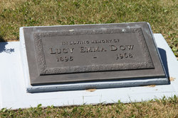
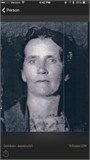
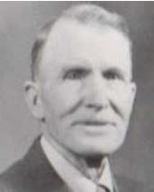
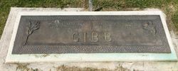
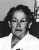
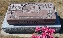
Lucy Emma Gibb Dow
| Birth | : | 12 Aug 1895 Lehi, Utah County, Utah, USA |
| Death | : | 11 Jun 1968 Lethbridge, Lethbridge Census Division, Alberta, Canada |
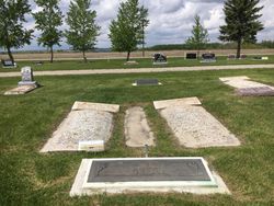
| Burial | : | Magrath Cemetery, Magrath, Claresholm Census Division, Canada |
| Coordinate | : | 49.3985700, -112.8648700 |
| Description | : | DOW — Emma Lucy Gibb, beloved wife of Mr. William Dow of 1122 7 St. N., passed away in the city on June 14 (NOTE: Cemetery record shows death date as June 11), at the age of 72 years. Mrs. Dow was born in Lehi, Utah and came to Raymond in 1901 with her parents, Mr. and Mrs. John L. Gibb. In 1914 she married William Dow. They settled in the Magrath area until 1926. They moved to the Diamond City area the same year where Mr. Dow operated a farm until 1960 when they retired and moved into Lethbridge.... Read More |
frequently asked questions (FAQ):
-
Where is Lucy Emma Gibb Dow's memorial?
Lucy Emma Gibb Dow's memorial is located at: Magrath Cemetery, Magrath, Claresholm Census Division, Canada.
-
When did Lucy Emma Gibb Dow death?
Lucy Emma Gibb Dow death on 11 Jun 1968 in Lethbridge, Lethbridge Census Division, Alberta, Canada
-
Where are the coordinates of the Lucy Emma Gibb Dow's memorial?
Latitude: 49.3985700
Longitude: -112.8648700
Family Members:
Parent
Spouse

Siblings

Children


Flowers:


Nearby Cemetories:
1. Magrath Cemetery
Magrath, Claresholm Census Division, Canada
Coordinate: 49.3985700, -112.8648700
2. Hutterville Hutterite Cemetery
Magrath, Claresholm Census Division, Canada
Coordinate: 49.3503165, -112.7701038
3. Rockport Colony Cemetery
Magrath, Claresholm Census Division, Canada
Coordinate: 49.3027780, -112.8136110
4. Spring Valley Hutterite Colony Cemetery
Spring Coulee, Claresholm Census Division, Canada
Coordinate: 49.3517043, -113.0551519
5. Spring Coulee Cemetery
Spring Coulee, Claresholm Census Division, Canada
Coordinate: 49.3412100, -113.0541400
6. Temple Hill Cemetery
Raymond, Lethbridge Census Division, Canada
Coordinate: 49.4916300, -112.6605200
7. East Raymond Hutterite Colony Cemetery
Raymond, Lethbridge Census Division, Canada
Coordinate: 49.4185305, -112.5791329
8. Stirling Mennonite Church Cemetery
Stirling, Lethbridge Census Division, Canada
Coordinate: 49.4607570, -112.5387970
9. Wolf Creek Hutterite Colony Cemetery
Stirling, Lethbridge Census Division, Canada
Coordinate: 49.4119142, -112.5163705
10. Crystal Spring Hutterite Colony Cemetery
Magrath, Claresholm Census Division, Canada
Coordinate: 49.1702490, -112.8048290
11. Stirling Cemetery
Stirling, Lethbridge Census Division, Canada
Coordinate: 49.5093400, -112.5380000
12. West Raley Hutterite Cemetery
Raley, Claresholm Census Division, Canada
Coordinate: 49.2908857, -113.2283616
13. Mountain View Cemetery
Lethbridge, Lethbridge Census Division, Canada
Coordinate: 49.6800385, -112.8297729
14. Woolford Cemetery
Woolford, Claresholm Census Division, Canada
Coordinate: 49.1945800, -113.1652300
15. Wilson Siding Hutterite Cemetery
Wilson, Lethbridge Census Division, Canada
Coordinate: 49.6203914, -112.5781130
16. Indian Battle Park
Lethbridge, Lethbridge Census Division, Canada
Coordinate: 49.6928200, -112.8582900
17. Saint Catherine Cemetery
Stand Off, Claresholm Census Division, Canada
Coordinate: 49.4516900, -113.3112300
18. Big Bend Hutterite Colony
Cardston, Claresholm Census Division, Canada
Coordinate: 49.1636110, -113.1411110
19. Standoff Hutterite Colony Cemetery
Stand Off, Claresholm Census Division, Canada
Coordinate: 49.4829507, -113.3130885
20. Archmount Cemetery
Lethbridge, Lethbridge Census Division, Canada
Coordinate: 49.7057900, -112.9017500
21. Saint Patrick's Cemetery
Lethbridge, Lethbridge Census Division, Canada
Coordinate: 49.7084618, -112.8428726
22. East Cardston Hutterite Cemetery
Cardston, Claresholm Census Division, Canada
Coordinate: 49.1908348, -113.2258004
23. New Dayton Community Cemetery
New Dayton, Lethbridge Census Division, Canada
Coordinate: 49.4254300, -112.3601800
24. Royal View Memorial Cemetery
Lethbridge, Lethbridge Census Division, Canada
Coordinate: 49.7518540, -112.8242250