
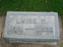

Luise Henriette Wilhelmine Gillmann Linderkamp
| Birth | : | 2 Jan 1901 Alvord, Lyon County, Iowa, USA |
| Death | : | 3 May 2000 Charles City, Floyd County, Iowa, USA |
| Burial | : | Riverside Cemetery, Rockford, Floyd County, USA |
| Coordinate | : | 43.0578003, -92.9464035 |
| Plot | : | Section 9 |
| Description | : | LUISE H. LINDERKAMP CHARLES CITY - Luise H. Linderkamp, 99, formerly of 703 N. Johnston St., died Wednesday (May 3, 2000) at the 11th St. Chautauqua Guest Home. Funeral services will be held at 10 a.m. Saturday at St. John Evangelical Lutheran Church, Main and Gilbert Streets in Charles City, with the Revs. Dennis D. Niezwaag and Mark A. Anderson officiating. Burial will be in Riverside Cemetery in Rockford. Visitation will be held from 5 to 7 p.m. today at the Fullerton Hage Funeral Home, 401 Blunt St., and one hour prior to services on Saturday at the church. Fullerton... Read More |
frequently asked questions (FAQ):
-
Where is Luise Henriette Wilhelmine Gillmann Linderkamp's memorial?
Luise Henriette Wilhelmine Gillmann Linderkamp's memorial is located at: Riverside Cemetery, Rockford, Floyd County, USA.
-
When did Luise Henriette Wilhelmine Gillmann Linderkamp death?
Luise Henriette Wilhelmine Gillmann Linderkamp death on 3 May 2000 in Charles City, Floyd County, Iowa, USA
-
Where are the coordinates of the Luise Henriette Wilhelmine Gillmann Linderkamp's memorial?
Latitude: 43.0578003
Longitude: -92.9464035
Family Members:
Parent
Spouse
Siblings

Children
Flowers:


Nearby Cemetories:
1. Riverside Cemetery
Rockford, Floyd County, USA
Coordinate: 43.0578003, -92.9464035
2. Ulsterville Cemetery
Ulster Township, Floyd County, USA
Coordinate: 43.0936012, -92.8842010
3. Flood Creek Cemetery
Floyd County, USA
Coordinate: 43.0391998, -92.8538971
4. Rock Grove Township Cemetery
Nora Springs, Floyd County, USA
Coordinate: 43.1227989, -92.9880981
5. Rudd Evergreen Cemetery
Rudd, Floyd County, USA
Coordinate: 43.1417007, -92.9214020
6. Park Cemetery
Nora Springs, Floyd County, USA
Coordinate: 43.1444016, -92.9982986
7. Saint Marys Catholic Cemetery
Roseville, Floyd County, USA
Coordinate: 43.0090000, -92.8134000
8. West Saint Charles United Methodist Cemetery
Floyd County, USA
Coordinate: 43.0580597, -92.7897186
9. Westside Cemetery
Marble Rock, Floyd County, USA
Coordinate: 42.9556007, -92.8739014
10. Hillside Cemetery
Marble Rock, Floyd County, USA
Coordinate: 42.9583015, -92.8666992
11. Spring Grove Cemetery
Nora Springs, Floyd County, USA
Coordinate: 43.1631012, -93.0211029
12. Owens Grove Cemetery
Cerro Gordo County, USA
Coordinate: 43.0825005, -93.1144180
13. Saint Patricks Catholic Cemetery
Dougherty, Cerro Gordo County, USA
Coordinate: 42.9227791, -93.0294418
14. Eden Presbyterian Cemetery
Meroa, Mitchell County, USA
Coordinate: 43.2131004, -92.9103012
15. West End Cemetery
Meroa, Mitchell County, USA
Coordinate: 43.2216682, -92.9250031
16. Oakwood Cemetery
Floyd, Floyd County, USA
Coordinate: 43.1178017, -92.7307968
17. Dudley Cemetery
Dudley (historical), Mitchell County, USA
Coordinate: 43.2252998, -92.8743973
18. Rock Creek Cemetery
Meroa, Mitchell County, USA
Coordinate: 43.2352791, -92.9225006
19. Halls Grove Cemetery
Greene, Butler County, USA
Coordinate: 42.8840100, -92.8782300
20. Rock Falls Cemetery
Rock Falls, Cerro Gordo County, USA
Coordinate: 43.2122192, -93.0858307
21. Pleasant Grove Cemetery
Powersville, Floyd County, USA
Coordinate: 42.9441986, -92.7446976
22. Calvary Cemetery
Osage, Mitchell County, USA
Coordinate: 43.2238998, -92.8300018
23. Riverside Cemetery
Charles City, Floyd County, USA
Coordinate: 43.0766983, -92.6881027
24. West Fork Cemetery
Franklin County, USA
Coordinate: 42.8918991, -93.0836029