
| Birth | : | 2 May 1918 Cabins, Grant County, West Virginia, USA |
| Death | : | 31 Jul 1997 Winchester City, Virginia, USA |
| Burial | : | Harmony Cemetery, Marlowe, Berkeley County, USA |
| Coordinate | : | 39.5868988, -77.8814011 |
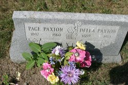
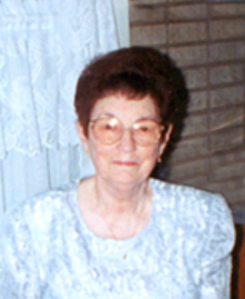
| Description | : | Lula was the daughter of Page Paxton and Della (Teter) Shreve Paxton. Lula married Frank William Reid (17 Jan 1917 - July 1979). Frank was the son of William Edgar Reid (1881-1958) and Vernie Catherine (Wissinger) Reed (1882-1974). In the 1940 U.S. Census, Frank and Lula were living in Falling Waters, Berkeley County, West Virginia. _____ Hagerstown Morning Herald Washington County, Maryland 1 Aug 1997 Marlowe, W.Va. - Lula Jane Reid, 79, of Broad Lane, died Thursday, July 31, 1997, at Winchester Medical Center in Winchester, Va. Born May 2, 1918, in Cabins, W.Va., she was the daughter of the late Page Emitt and Della Teeter Paxton.... Read More |
frequently asked questions (FAQ):
-
Where is Lula Jane Paxton Reid's memorial?
Lula Jane Paxton Reid's memorial is located at: Harmony Cemetery, Marlowe, Berkeley County, USA.
-
When did Lula Jane Paxton Reid death?
Lula Jane Paxton Reid death on 31 Jul 1997 in Winchester City, Virginia, USA
-
Where are the coordinates of the Lula Jane Paxton Reid's memorial?
Latitude: 39.5868988
Longitude: -77.8814011
Family Members:
Parent

Spouse

Siblings
Children
Flowers:


Nearby Cemetories:
1. Harmony Cemetery
Marlowe, Berkeley County, USA
Coordinate: 39.5868988, -77.8814011
2. Old Falling Waters Cemetery
Falling Waters, Berkeley County, USA
Coordinate: 39.5618350, -77.8900070
3. River View Cemetery
Williamsport, Washington County, USA
Coordinate: 39.5980606, -77.8247681
4. Pinesburg Mennonite Church Cemetery
Pinesburg, Washington County, USA
Coordinate: 39.6299500, -77.8609300
5. Friend's Family Cemetery
Williamsport, Washington County, USA
Coordinate: 39.6029110, -77.8225990
6. Rehobeth United Methodist Church Cemetery
Williamsport, Washington County, USA
Coordinate: 39.5981660, -77.8205850
7. Saint Augustine's Graveyard
Williamsport, Washington County, USA
Coordinate: 39.5997009, -77.8206024
8. Greenlawn Cemetery
Williamsport, Washington County, USA
Coordinate: 39.5922012, -77.8125000
9. Crowl Cemetery
Bedington, Berkeley County, USA
Coordinate: 39.5291867, -77.8816979
10. Little Georgetown Cemetery
Little Georgetown, Berkeley County, USA
Coordinate: 39.5838300, -77.9563100
11. Falling Waters Presbyterian Cemetery
Spring Mills, Berkeley County, USA
Coordinate: 39.5580254, -77.9534454
12. Clear Spring Mennonite Church Cemetery
Clear Spring, Washington County, USA
Coordinate: 39.6460800, -77.9138500
13. Marlott Cemetery
Berkeley County, USA
Coordinate: 39.5275960, -77.9199060
14. Light Cemetery #1
Bedington, Berkeley County, USA
Coordinate: 39.5162090, -77.8972190
15. Saint Paul's Lutheran Church Cemetery
Clear Spring, Washington County, USA
Coordinate: 39.6587200, -77.8806500
16. Little Metropolitan AME Cemetery
Clear Spring, Washington County, USA
Coordinate: 39.6520900, -77.9311700
17. Green Spring Cemetery
Clear Spring, Washington County, USA
Coordinate: 39.6253014, -77.9669037
18. Rose Hill Cemetery
Clear Spring, Washington County, USA
Coordinate: 39.6580400, -77.9177500
19. Saint Peters Lutheran Church Cemetery
Clear Spring, Washington County, USA
Coordinate: 39.6543999, -77.9310989
20. Saint Michael's Catholic Cemetery
Clear Spring, Washington County, USA
Coordinate: 39.6544000, -77.9315000
21. Boyd Farm Graveyard
Clear Spring, Washington County, USA
Coordinate: 39.6475350, -77.9463240
22. Trinity Christian Church Cemetery
Clear Spring, Washington County, USA
Coordinate: 39.6604540, -77.9201530
23. Clear Spring Methodist Episcopal Cemetery
Clear Spring, Washington County, USA
Coordinate: 39.6575790, -77.9284290
24. Allensville Cemetery
Hedgesville, Berkeley County, USA
Coordinate: 39.5792999, -77.9886017