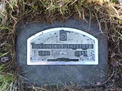
Lula Kathleen Ellis Rutherford
| Birth | : | 22 Jan 1914 Benkelman, Dundy County, Nebraska, USA |
| Death | : | Oct 1959 Washington, USA |
| Burial | : | Omak Memorial Cemetery, Okanogan, Okanogan County, USA |
| Coordinate | : | 48.3874000, -119.5565800 |
| Plot | : | B3-4-4 |
| Description | : | She was first married to Glenn Irvin Woodward (24 September 1911 – 12 April 1986). * * * * For more details, see the book, History of Twelve Generations of the Ellis Family by Ann Ellis Sheek, 1974. * * * * Lula C Woodward United States Census, 1940 Name: Lula C Woodward Event Type: Census Event Date: 1940 • Event Place: Coquille, Election Precinct 40 Coquille Southwest, Coos, Oregon, United States • Last Place of Residence: Benkelman, Dundy, Nebraska Gender: Female Age: 26 Marital Status: Married Race: White Race (Original):... Read More |
frequently asked questions (FAQ):
-
Where is Lula Kathleen Ellis Rutherford's memorial?
Lula Kathleen Ellis Rutherford's memorial is located at: Omak Memorial Cemetery, Okanogan, Okanogan County, USA.
-
When did Lula Kathleen Ellis Rutherford death?
Lula Kathleen Ellis Rutherford death on Oct 1959 in Washington, USA
-
Where are the coordinates of the Lula Kathleen Ellis Rutherford's memorial?
Latitude: 48.3874000
Longitude: -119.5565800
Family Members:
Parent
Spouse
Siblings
Children
Flowers:
Nearby Cemetories:
1. Omak Memorial Cemetery
Okanogan, Okanogan County, USA
Coordinate: 48.3874000, -119.5565800
2. Okanogan Valley Memorial Gardens
Omak, Okanogan County, USA
Coordinate: 48.3911018, -119.5691986
3. Okanogan City Cemetery
Okanogan, Okanogan County, USA
Coordinate: 48.3546982, -119.6061020
4. Spring Coulee Family Cemetery
Okanogan County, USA
Coordinate: 48.3895950, -119.6289460
5. Sand Flats Cemetery
Omak, Okanogan County, USA
Coordinate: 48.4157600, -119.4836600
6. Stoddard Gravesite
Okanogan, Okanogan County, USA
Coordinate: 48.4531140, -119.5411680
7. Saint Marys Mission Catholic Cemetery
Omak, Okanogan County, USA
Coordinate: 48.3752800, -119.4452800
8. Swipkin Family Cemetery
Riverside, Okanogan County, USA
Coordinate: 48.4664270, -119.4618660
9. Brooks Cemetery
Omak, Okanogan County, USA
Coordinate: 48.3786110, -119.3941670
10. Riverside Cemetery
Riverside, Okanogan County, USA
Coordinate: 48.4944400, -119.5022200
11. Cameron Lake Pioneer Memorial Cemetery
Malott, Okanogan County, USA
Coordinate: 48.2708330, -119.5700000
12. Malott Community Cemetery
Malott, Okanogan County, USA
Coordinate: 48.2925000, -119.7047300
13. Booher Grave
Riverside, Okanogan County, USA
Coordinate: 48.3409070, -119.3244000
14. Ruby Cemetery
Okanogan County, USA
Coordinate: 48.5085983, -119.7221985
15. Chiliwist Cemetery
Okanogan County, USA
Coordinate: 48.2630997, -119.7363968
16. Conconully Cemetery
Conconully, Okanogan County, USA
Coordinate: 48.5441600, -119.7400100
17. Tunk Valley Cemetery
Riverside, Okanogan County, USA
Coordinate: 48.5222015, -119.3242035
18. South Pine Creek Cemetery
Riverside, Okanogan County, USA
Coordinate: 48.5925900, -119.5663400
19. Fort Okanogan Memorial Cemetery
Okanogan, Okanogan County, USA
Coordinate: 48.1594009, -119.6632996
20. Pine Creek Cemetery
Tonasket, Okanogan County, USA
Coordinate: 48.6330560, -119.6502780
21. Kartar Cemetery
Okanogan County, USA
Coordinate: 48.2197100, -119.2694500
22. Cook Family Cemetery
Carlton, Okanogan County, USA
Coordinate: 48.6083300, -119.3544400
23. Cook Place Cemetery
Tonasket, Okanogan County, USA
Coordinate: 48.6083330, -119.3544440
24. Elizabeth Osborn Mikel Gravesite
Brewster, Okanogan County, USA
Coordinate: 48.1498900, -119.7514700

