Lura Ethel Clark Rice
| Birth | : | 2 Oct 1867 Lee County, Illinois, USA |
| Death | : | 16 May 1950 Riverside County, California, USA |
| Burial | : | Jamestown Cemetery, Jamestown, Ottawa County, USA |
| Coordinate | : | 42.8163986, -85.8411026 |
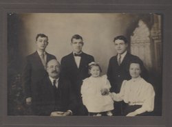
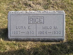
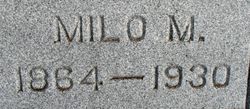
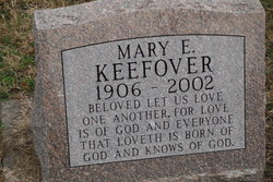
| Description | : | Lura E. (Clark) Rice, d/o James and Emma (Vickery) Clark, was married to Milo M. Rice with whom she had four children, George C. Rice, William F. Rice, Clarence A. Rice and Mary E. (Rice) Keefover. |
frequently asked questions (FAQ):
-
Where is Lura Ethel Clark Rice's memorial?
Lura Ethel Clark Rice's memorial is located at: Jamestown Cemetery, Jamestown, Ottawa County, USA.
-
When did Lura Ethel Clark Rice death?
Lura Ethel Clark Rice death on 16 May 1950 in Riverside County, California, USA
-
Where are the coordinates of the Lura Ethel Clark Rice's memorial?
Latitude: 42.8163986
Longitude: -85.8411026
Family Members:
Parent
Spouse
Siblings
Children
Flowers:
Nearby Cemetories:
1. Jamestown Cemetery
Jamestown, Ottawa County, USA
Coordinate: 42.8163986, -85.8411026
2. Star Cemetery
Jamestown Township, Ottawa County, USA
Coordinate: 42.7961006, -85.8227997
3. Forest Grove Cemetery
Jamestown, Ottawa County, USA
Coordinate: 42.8044014, -85.8707962
4. Zutphen Cemetery
Jamestown, Ottawa County, USA
Coordinate: 42.8161011, -85.8799973
5. Shackhuddle Cemetery
Georgetown Township, Ottawa County, USA
Coordinate: 42.8634460, -85.8229030
6. Hanley Cemetery
Jenison, Ottawa County, USA
Coordinate: 42.8565090, -85.7924940
7. Ridgeview Memorial Gardens
Georgetown Township, Ottawa County, USA
Coordinate: 42.8632600, -85.8023900
8. Floral View Memorial Gardens
Jenison, Ottawa County, USA
Coordinate: 42.8699989, -85.8032990
9. Saint Sebastian Catholic Cemetery
Byron Center, Kent County, USA
Coordinate: 42.7944440, -85.7619440
10. Winegar Cemetery
Byron Center, Kent County, USA
Coordinate: 42.7933006, -85.7497025
11. Saint Marys Catholic Church Cemetery of New Salem
Salem Township, Allegan County, USA
Coordinate: 42.7543900, -85.7883700
12. Sprik Family Cemetery
Zeeland, Ottawa County, USA
Coordinate: 42.8197700, -85.9409000
13. Boynton Cemetery
Byron Center, Kent County, USA
Coordinate: 42.8377991, -85.7433014
14. Visitation Catholic Church Cemetery
Dorr Township, Allegan County, USA
Coordinate: 42.7678840, -85.7622740
15. Salem Township Cemetery
Burnips, Allegan County, USA
Coordinate: 42.7387910, -85.8390830
16. Georgetown Township Cemetery
Hudsonville, Ottawa County, USA
Coordinate: 42.8941710, -85.8519780
17. East Drenthe Cemetery
Drenthe, Ottawa County, USA
Coordinate: 42.7747002, -85.9313965
18. Jenison Cemetery
Jenison, Ottawa County, USA
Coordinate: 42.8897018, -85.8019028
19. Beaverdam Cemetery
Beaverdam, Ottawa County, USA
Coordinate: 42.8477800, -85.9447200
20. Old Drenthe Cemetery
Zeeland Township, Ottawa County, USA
Coordinate: 42.7792830, -85.9419360
21. Sleepy Hollow Pet Cemetery and Crematory
Byron Center, Kent County, USA
Coordinate: 42.8477040, -85.7329940
22. Old Vriesland Cemetery
Zeeland, Ottawa County, USA
Coordinate: 42.8050995, -85.9570313
23. Vriesland Cemetery
Vriesland, Ottawa County, USA
Coordinate: 42.8191986, -85.9591980
24. Smallpox Cemetery
Georgetown Township, Ottawa County, USA
Coordinate: 42.8994500, -85.8063100


