
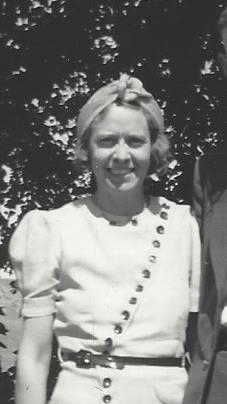
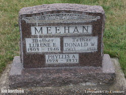
Lurene Estelle Miller Meehan
| Birth | : | 5 Aug Weeping Water, Cass County, Nebraska, USA |
| Death | : | 26 Aug 1946 Savannah, Andrew County, Missouri, USA |
| Burial | : | Lewistown City Cemetery, Lewistown, Fergus County, USA |
| Coordinate | : | 47.0674600, -109.4449700 |
frequently asked questions (FAQ):
-
Where is Lurene Estelle Miller Meehan's memorial?
Lurene Estelle Miller Meehan's memorial is located at: Lewistown City Cemetery, Lewistown, Fergus County, USA.
-
When did Lurene Estelle Miller Meehan death?
Lurene Estelle Miller Meehan death on 26 Aug 1946 in Savannah, Andrew County, Missouri, USA
-
Where are the coordinates of the Lurene Estelle Miller Meehan's memorial?
Latitude: 47.0674600
Longitude: -109.4449700
Family Members:
Parent

Spouse
Siblings

Children
Flowers:


Nearby Cemetories:
1. Lewistown City Cemetery
Lewistown, Fergus County, USA
Coordinate: 47.0674600, -109.4449700
2. Calvary Cemetery
Lewistown, Fergus County, USA
Coordinate: 47.0755140, -109.4238710
3. Central Montana Memorial Gardens
Lewistown, Fergus County, USA
Coordinate: 47.1526000, -109.4297000
4. Beaver Creek Cemetery
Lewistown, Fergus County, USA
Coordinate: 46.9510994, -109.5397034
5. King Colony Cemetery
King Colony Ranch, Fergus County, USA
Coordinate: 47.0557000, -109.6416000
6. Hilger Cemetery
Hilger, Fergus County, USA
Coordinate: 47.2297000, -109.3446000
7. Giltedge Cemetery
Giltedge, Fergus County, USA
Coordinate: 47.1323800, -109.2033700
8. Great Divide Cemetery
Piper, Fergus County, USA
Coordinate: 46.9978000, -109.2046000
9. Moore Cemetery
Moore, Fergus County, USA
Coordinate: 46.9693985, -109.6802979
10. Kendall Cemetery
Fergus County, USA
Coordinate: 47.2848000, -109.4541000
11. Fort Maginnis Cemetery
Giltedge, Fergus County, USA
Coordinate: 47.1869011, -109.1461029
12. Danvers Cemetery
Danvers, Fergus County, USA
Coordinate: 47.2292810, -109.7181200
13. Deerfield Cemetery
Fergus County, USA
Coordinate: 47.2604000, -109.6819000
14. Forest Grove Cemetery
Fergus County, USA
Coordinate: 46.9909000, -109.0752000
15. Moccasin Cemetery
Moccasin, Judith Basin County, USA
Coordinate: 47.0411830, -109.9093000
16. Buffalo Cemetery
Judith Basin County, USA
Coordinate: 46.8526000, -109.8242330
17. Ayers Ranch Colony Cemetery
Ayers Ranch Colony, Fergus County, USA
Coordinate: 47.0508000, -108.9514000
18. Ayers Ranch Hutterite Cemetery
Grass Range, Fergus County, USA
Coordinate: 47.0507550, -108.9514013
19. Philbrook Cemetery
Hobson, Judith Basin County, USA
Coordinate: 46.9831009, -109.9558029
20. Ford's Creek Colony
Grass Range, Fergus County, USA
Coordinate: 47.1306882, -108.9208610
21. Ubet-Garneill Cemetery
Judith Basin County, USA
Coordinate: 46.7478330, -109.7800000
22. Benchland Cemetery
Judith Basin County, USA
Coordinate: 47.0839005, -110.0500031
23. Hillcrest Cemetery
Denton, Fergus County, USA
Coordinate: 47.3133011, -109.9349976
24. Roy Cemetery
Roy, Fergus County, USA
Coordinate: 47.3404680, -108.9571450