
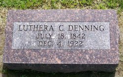
Luthera Cutler Hervey Denning
| Birth | : | 18 Jul 1842 LaGrange, LaGrange County, Indiana, USA |
| Death | : | 4 Dec 1922 Appleton City, St. Clair County, Missouri, USA |
| Burial | : | Wynyard General Cemetery, Wynyard, Waratah-Wynyard Council, Australia |
| Coordinate | : | -40.9820596, 145.7179781 |
| Description | : | Obituary: DIES AT ADVANCED AGE Luthera C. Denning (nee Hervey) was born in Indiana, July 18, 1842, and died at her home west of Appleton City, Mo., December 4, 1922, age 80 years, 3 months and 16 days. Her childhood days were spent in the land of her birth. She was the daughter of a Methodist minister and early in life gave her heart to God and joined a Baptist church. She later joined a Christian church, living a faithful and consistent Christian life until death came. She was married to David F. Spoor August... Read More |
frequently asked questions (FAQ):
-
Where is Luthera Cutler Hervey Denning's memorial?
Luthera Cutler Hervey Denning's memorial is located at: Wynyard General Cemetery, Wynyard, Waratah-Wynyard Council, Australia.
-
When did Luthera Cutler Hervey Denning death?
Luthera Cutler Hervey Denning death on 4 Dec 1922 in Appleton City, St. Clair County, Missouri, USA
-
Where are the coordinates of the Luthera Cutler Hervey Denning's memorial?
Latitude: -40.9820596
Longitude: 145.7179781
Family Members:

Flowers:


Nearby Cemetories:
1. Wynyard General Cemetery
Wynyard, Waratah-Wynyard Council, Australia
Coordinate: -40.9820596, 145.7179781
2. Jenner Street Old General Cemetery
Wynyard, Waratah-Wynyard Council, Australia
Coordinate: -40.9851700, 145.7277810
3. Flowerdale Cemetery
Flowerdale, Waratah-Wynyard Council, Australia
Coordinate: -40.9679460, 145.6740580
4. Table Cape Cemetery
Table Cape, Waratah-Wynyard Council, Australia
Coordinate: -40.9463750, 145.7279330
5. Lower Mount Hicks Cemetery
Lower Mount Hicks, Waratah-Wynyard Council, Australia
Coordinate: -41.0422810, 145.7384950
6. Somerset Cemetery
Somerset, Waratah-Wynyard Council, Australia
Coordinate: -41.0434790, 145.8292770
7. Burnie Lawn Cemetery
East Cam, Burnie City, Australia
Coordinate: -41.0583700, 145.8518460
8. Burnie Anglican Church Cemetery
Burnie, Burnie City, Australia
Coordinate: -41.0523570, 145.9045550
9. Henrietta Cemetery
Henrietta, Waratah-Wynyard Council, Australia
Coordinate: -41.1543686, 145.6882431
10. Wivenhoe General Cemetery
Burnie, Burnie City, Australia
Coordinate: -41.0722433, 145.9305850
11. Ridgley General Cemetery
Ridgley, Burnie City, Australia
Coordinate: -41.1506070, 145.8236570
12. Rocky Cape Cemetery
Rocky Cape, Circular Head Council, Australia
Coordinate: -40.8948900, 145.4608770
13. Penguin General Cemetery
Penguin, Central Coast Council, Australia
Coordinate: -41.1118724, 146.0646653
14. South Riana Uniting Church Cemetery
Central Coast Council, Australia
Coordinate: -41.2351280, 145.9792410
15. Central Coast Memorial Park
Ulverstone, Central Coast Council, Australia
Coordinate: -41.1397940, 146.1081230
16. George Woodhouse Lookout
Riana, Central Coast Council, Australia
Coordinate: -41.2818184, 145.9948120
17. St. John's Anglican Churchyard
North Motton, Central Coast Council, Australia
Coordinate: -41.2076090, 146.1088350
18. North Motton Methodist Cemetery
North Motton, Central Coast Council, Australia
Coordinate: -41.2091270, 146.1096290
19. St. Bartholomew's Anglican Cemetery
Forest, Circular Head Council, Australia
Coordinate: -40.8553130, 145.2469170
20. Ulverstone General Cemetery
Ulverstone, Central Coast Council, Australia
Coordinate: -41.1625310, 146.1637200
21. Ulverstone Anglican Church Cemetery
Ulverstone, Central Coast Council, Australia
Coordinate: -41.1584540, 146.1683450
22. Stanley Burial Ground
Stanley, Circular Head Council, Australia
Coordinate: -40.7594770, 145.2984500
23. Circular Head Lawn Cemetery
Stanley, Circular Head Council, Australia
Coordinate: -40.8141700, 145.2432500
24. North West Crematorium and Memorial Garden
Ulverstone, Central Coast Council, Australia
Coordinate: -41.1592500, 146.1943370