
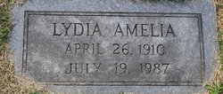

Lydia Amelia Hoffman Sullivan
| Birth | : | 26 Apr 1910 Jamestown, Moniteau County, Missouri, USA |
| Death | : | 19 Jul 1987 Gainesville, Alachua County, Florida, USA |
| Burial | : | Sunset Memory Gardens, Parkersburg, Wood County, USA |
| Coordinate | : | 39.2496986, -81.5911026 |
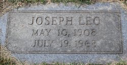
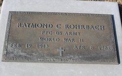
| Description | : | Lydia A. Rohrbach, 77, Gainesville, Fla., formerly of California, died Sunday at Gainesville, Fla. She was born April 26, 1910, near Jamestown, a daughter of Frank and Laura Scheriff Hoffman. She was married in 1939 to Leo Sullivan, who died July 19, 1968. She then remarried in 1969 to Raymond C. Rohrbach, who died April 6, 1982. A graduate of California High School, she was a member of the California United Church of Christ. She had been employed as a schoolteacher, and as a clerk at Houser-Lehman Drug Store, California. Before retiring in 1970, she was a clerk... Read More |
frequently asked questions (FAQ):
-
Where is Lydia Amelia Hoffman Sullivan's memorial?
Lydia Amelia Hoffman Sullivan's memorial is located at: Sunset Memory Gardens, Parkersburg, Wood County, USA.
-
When did Lydia Amelia Hoffman Sullivan death?
Lydia Amelia Hoffman Sullivan death on 19 Jul 1987 in Gainesville, Alachua County, Florida, USA
-
Where are the coordinates of the Lydia Amelia Hoffman Sullivan's memorial?
Latitude: 39.2496986
Longitude: -81.5911026
Family Members:
Spouse
Flowers:


Nearby Cemetories:
1. Sunset Memory Gardens
Parkersburg, Wood County, USA
Coordinate: 39.2496986, -81.5911026
2. Tracewell Cemetery
Parkersburg, Wood County, USA
Coordinate: 39.2498000, -81.5870000
3. Posey Cemetery
Lubeck, Wood County, USA
Coordinate: 39.2437860, -81.5980020
4. Old Pest-House Cemetery
Parkersburg, Wood County, USA
Coordinate: 39.2581200, -81.5713960
5. River Hill Cemetery
Blennerhassett, Wood County, USA
Coordinate: 39.2636300, -81.6094400
6. Maddox Cemetery
Blennerhassett, Wood County, USA
Coordinate: 39.2608170, -81.6126500
7. Blennerhassett Family Burial Grounds
Blennerhassett Island View Addition, Wood County, USA
Coordinate: 39.2716217, -81.6009064
8. Bethel Baptist Church Cemetery
Parkersburg, Wood County, USA
Coordinate: 39.2511700, -81.6239900
9. Trinity Episcopal Church Columbarium
Parkersburg, Wood County, USA
Coordinate: 39.2665240, -81.5614570
10. Holliday Cemetery
Parkersburg, Wood County, USA
Coordinate: 39.2619019, -81.5560989
11. Cedarville Cemetery
Washington County, USA
Coordinate: 39.2769012, -81.6081009
12. Tavenner Cemetery
Parkersburg, Wood County, USA
Coordinate: 39.2546997, -81.5507965
13. Wright Cemetery
Parkersburg, Wood County, USA
Coordinate: 39.2374340, -81.5496962
14. Evergreen Cemetery South
South Parkersburg, Wood County, USA
Coordinate: 39.2442017, -81.5460968
15. Lubeck Cemetery
Lubeck, Wood County, USA
Coordinate: 39.2368400, -81.6337400
16. Riverview Cemetery
Parkersburg, Wood County, USA
Coordinate: 39.2735020, -81.5543890
17. Mathews Cemetery
Wood County, USA
Coordinate: 39.2500000, -81.5413971
18. Good Shepherd Episcopal Church Columbarium
Wood County, USA
Coordinate: 39.2670300, -81.5464980
19. Rockland Cemetery
Belpre, Washington County, USA
Coordinate: 39.2813988, -81.6200027
20. DeSales Heights Convent
Parkersburg, Wood County, USA
Coordinate: 39.2763700, -81.5535050
21. Saint Francis Xavier Catholic Cemetery
Parkersburg, Wood County, USA
Coordinate: 39.2703018, -81.5430984
22. Pleasant View Cemetery
Pettyville, Wood County, USA
Coordinate: 39.2075300, -81.5770100
23. Parkersburg Memorial Gardens
Parkersburg, Wood County, USA
Coordinate: 39.2798310, -81.5491430
24. First Lutheran Church Columbarium
Parkersburg, Wood County, USA
Coordinate: 39.2729370, -81.5365440