M2C Robert Eugene “Gene” Snider
| Birth | : | 1 Feb 1911 Richmond, Ray County, Missouri, USA |
| Death | : | 27 Jan 1991 Richmond, Ray County, Missouri, USA |
| Burial | : | Brownsville Baptist Church Cemetery, Brownsville, Marlboro County, USA |
| Coordinate | : | 34.4417000, -79.6268997 |
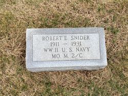
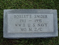
| Inscription | : | WWII US NAVY MO M 2/C |
| Description | : | KANSAS CITY STAR OBITS FOR JANUARY 29, 1991 Robert Eugene Snider, 79, Richmond, died Jan. 27, 1991, at Ray County Memorial Hospital, Richmond. He was a lifelong Richmond area resident. Mr. Snider was a maintenance supervisor for the Richmond School District before he retired. Earlier he was a carpenter. He was a member of Local 938 of the Carpenters Union, Richmond. He was a member of the Liberty Church of Christ, near Norborne, Mo. He was an Army and Navy veteran of World War II. Survivors include a sister, May Coffman, Richmond. Services will be at 1:30 p.m.... Read More |
frequently asked questions (FAQ):
-
Where is M2C Robert Eugene “Gene” Snider's memorial?
M2C Robert Eugene “Gene” Snider's memorial is located at: Brownsville Baptist Church Cemetery, Brownsville, Marlboro County, USA.
-
When did M2C Robert Eugene “Gene” Snider death?
M2C Robert Eugene “Gene” Snider death on 27 Jan 1991 in Richmond, Ray County, Missouri, USA
-
Where are the coordinates of the M2C Robert Eugene “Gene” Snider's memorial?
Latitude: 34.4417000
Longitude: -79.6268997
Family Members:
Parent
Spouse
Siblings
Flowers:
Nearby Cemetories:
1. Brownsville Baptist Church Cemetery
Brownsville, Marlboro County, USA
Coordinate: 34.4417000, -79.6268997
2. Pleasant Hill Missionary Baptist Church Cemetery
Blenheim, Marlboro County, USA
Coordinate: 34.4474590, -79.6301720
3. Gray Cemetery
Blenheim, Marlboro County, USA
Coordinate: 34.4534000, -79.6209900
4. Bristow Free Will Baptist Church Cemetery
Bristow, Marlboro County, USA
Coordinate: 34.4179993, -79.6191025
5. Old Brownsville Church Cemetery
Bristow, Marlboro County, USA
Coordinate: 34.4260902, -79.6518631
6. Coxe Family Cemetery
Blenheim, Marlboro County, USA
Coordinate: 34.4278300, -79.5965000
7. Berry Cemetery
Marlboro County, USA
Coordinate: 34.4729480, -79.6257830
8. Mossy Bay Cemetery
Marlboro County, USA
Coordinate: 34.4731050, -79.6187880
9. Parnassus Graveyard
Blenheim, Marlboro County, USA
Coordinate: 34.4925003, -79.6457977
10. Bethlehem Methodist Cemetery
Brownsville, Marlboro County, USA
Coordinate: 34.3910500, -79.5981090
11. Cedar Fall Missionary Baptist Church Cemetery
Blenheim, Marlboro County, USA
Coordinate: 34.4850100, -79.6733700
12. McDowell Memorial Cemetery
Marlboro County, USA
Coordinate: 34.3956800, -79.5823200
13. East Marlboro Baptist Church Cemetery
Brownsville, Marlboro County, USA
Coordinate: 34.3889430, -79.5913500
14. Drake-Dudley Cemetery
Blenheim, Marlboro County, USA
Coordinate: 34.5029890, -79.6526550
15. Holy Rood Cemetery
Blenheim, Marlboro County, USA
Coordinate: 34.5036040, -79.6522200
16. Blenheim Cemetery
Marlboro County, USA
Coordinate: 34.5049300, -79.6532800
17. First Mineral Springs Baptist Cemetery
Blenheim, Marlboro County, USA
Coordinate: 34.5093220, -79.6422010
18. Sardis Church Cemetery
Blenheim, Marlboro County, USA
Coordinate: 34.5043510, -79.6652240
19. Cain Cemetery
Mallory, Dillon County, USA
Coordinate: 34.4009960, -79.5519800
20. Timothy Rogers Cemetery
Dillon County, USA
Coordinate: 34.4008000, -79.5516000
21. Mumford Cemetery
Bennettsville, Marlboro County, USA
Coordinate: 34.5120000, -79.6639170
22. Blue Family Cemetery
Bennettsville, Marlboro County, USA
Coordinate: 34.5032480, -79.6985050
23. McLeod Cemetery
Dillon County, USA
Coordinate: 34.4618988, -79.5223999
24. Smith Hayes Cemetery
Latta, Dillon County, USA
Coordinate: 34.3560000, -79.5775000

