
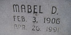

Mabel Delia Hare Griffin
| Birth | : | 3 Feb 1906 Mitchell County, Kansas, USA |
| Death | : | 26 Apr 1991 Minneapolis, Ottawa County, Kansas, USA |
| Burial | : | Thayer Cemetery, Thayer, Oregon County, USA |
| Coordinate | : | 36.5152200, -91.5395100 |
| Plot | : | blk 9<>10 |
| Inscription | : | "How Great Thou Art" |
| Description | : | From the Minneapolis Messenger Minneapolis, Kansas (Ottawa County) Date not recorded MABEL D. GRIFFIN Mabel D. Griffin was born February 3, 1906 on a farm in Mitchell County, the daughter of Edwin and Myrtle Childs Hare. She departed this life on Friday, April 26, 1991 at the Ottawa County Hospital in Minneapolis having reached the age of 85 years 2 months and 23 days. She was a member of the Community Bible Church and the VFW Auxiliary in Minneapolis. (part of next sentence missing) nington until 1951 when they moved to Minneapolis, returning to Bennington in 1953. Her husband preceded her in death June 24, 1983.... Read More |
frequently asked questions (FAQ):
-
Where is Mabel Delia Hare Griffin's memorial?
Mabel Delia Hare Griffin's memorial is located at: Thayer Cemetery, Thayer, Oregon County, USA.
-
When did Mabel Delia Hare Griffin death?
Mabel Delia Hare Griffin death on 26 Apr 1991 in Minneapolis, Ottawa County, Kansas, USA
-
Where are the coordinates of the Mabel Delia Hare Griffin's memorial?
Latitude: 36.5152200
Longitude: -91.5395100
Family Members:
Parent
Spouse
Siblings
Flowers:


Nearby Cemetories:
1. Thayer Cemetery
Thayer, Oregon County, USA
Coordinate: 36.5152200, -91.5395100
2. Old Town Church of God
Old Town, Oregon County, USA
Coordinate: 36.5004900, -91.5451800
3. Ragan Cemetery
Thayer, Oregon County, USA
Coordinate: 36.5235863, -91.5213242
4. Spring City Cemetery
Mammoth Spring, Fulton County, USA
Coordinate: 36.4983360, -91.5308040
5. Spring City Cemetery #2
Mammoth Spring, Fulton County, USA
Coordinate: 36.4982800, -91.5299400
6. Davis Cemetery
Fulton County, USA
Coordinate: 36.4991989, -91.5643997
7. Old George Martin Farm Cemetery
Allen Ford, Oregon County, USA
Coordinate: 36.5374850, -91.5230010
8. Riverside Cemetery
Mammoth Spring, Fulton County, USA
Coordinate: 36.4838982, -91.5406036
9. N B Allen Ford
Allen Ford, Oregon County, USA
Coordinate: 36.5411700, -91.5172900
10. Clifton Cemetery
Clifton, Oregon County, USA
Coordinate: 36.5511017, -91.5350037
11. Brenner Farm Cemetery
Allen Ford, Oregon County, USA
Coordinate: 36.5477000, -91.5065400
12. Two Mile Cemetery
Thayer, Oregon County, USA
Coordinate: 36.5485700, -91.5748800
13. Bledsaw Cemetery
Thayer, Oregon County, USA
Coordinate: 36.5595741, -91.5537949
14. McCameron Cemetery
Thayer, Oregon County, USA
Coordinate: 36.5103073, -91.6037903
15. Clifton Cemetery
Sloan Ford, Oregon County, USA
Coordinate: 36.5677900, -91.5329000
16. Union Hill Cemetery
Brandsville, Howell County, USA
Coordinate: 36.5256341, -91.4746829
17. Jeff Cemetery
Jeff, Oregon County, USA
Coordinate: 36.5256166, -91.4746129
18. Field Creek Cemetery
Mammoth Spring, Fulton County, USA
Coordinate: 36.4693985, -91.5042038
19. Davis Cemetery
Thayer, Oregon County, USA
Coordinate: 36.5339508, -91.4751358
20. Sergeant-Mount Olive Cemetery
Thayer, Oregon County, USA
Coordinate: 36.5634390, -91.5755830
21. Whiteside Cemetery
Fulton County, USA
Coordinate: 36.4958000, -91.6053009
22. Buehler Farm Cemetery
Clifton, Oregon County, USA
Coordinate: 36.5639496, -91.4845810
23. Roth Cemetery
Sloan Ford, Oregon County, USA
Coordinate: 36.5808945, -91.5498657
24. Dode Jones Farm Cemetery
Sloan Ford, Oregon County, USA
Coordinate: 36.5804900, -91.5568800