| Birth | : | 3 May 1866 Brown County, Ohio, USA |
| Death | : | 10 Oct 1953 Clermont County, Ohio, USA |
| Burial | : | Tate Township Cemetery, Bethel, Clermont County, USA |
| Coordinate | : | 38.9592018, -84.0742035 |
| Plot | : | Sec. 11A, Lot 50 |
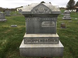
| Inscription | : | Groppenbacher |
| Description | : | M.J. Groppenbacher is described as a ".....successful farmer of Tate Township....largely self-made and has reached prosperity by the industry and thrift of himself and his wife (Hattie). This short biography is quoted from the "History of Clermont and Brown Counties, Ohio", Ed.1913. |
frequently asked questions (FAQ):
-
Where is Mack Joseph “M.J.” Groppenbacher's memorial?
Mack Joseph “M.J.” Groppenbacher's memorial is located at: Tate Township Cemetery, Bethel, Clermont County, USA.
-
When did Mack Joseph “M.J.” Groppenbacher death?
Mack Joseph “M.J.” Groppenbacher death on 10 Oct 1953 in Clermont County, Ohio, USA
-
Where are the coordinates of the Mack Joseph “M.J.” Groppenbacher's memorial?
Latitude: 38.9592018
Longitude: -84.0742035
Family Members:
Parent
Spouse
Siblings
Flowers:
Nearby Cemetories:
1. Tate Township Cemetery
Bethel, Clermont County, USA
Coordinate: 38.9592018, -84.0742035
2. Early Settlers Burying Ground
Bethel, Clermont County, USA
Coordinate: 38.9591600, -84.0741600
3. Bredwell Cemetery
Tate Township, Clermont County, USA
Coordinate: 38.9356300, -84.0776600
4. Hunt Cemetery
Bethel, Clermont County, USA
Coordinate: 38.9400830, -84.0558330
5. Brown Family Cemetery
Bethel, Clermont County, USA
Coordinate: 38.9838390, -84.0811730
6. Reed Cemetery
Bethel, Clermont County, USA
Coordinate: 38.9889330, -84.0799330
7. Swing Family Cemetery
Bethel, Clermont County, USA
Coordinate: 38.9750220, -84.1083140
8. Clover Cemetery
Williamsburg, Clermont County, USA
Coordinate: 38.9986800, -84.0416700
9. Sugartree Cemetery
Tate Township, Clermont County, USA
Coordinate: 38.9682999, -84.1343994
10. Moyer Cemetery
Pike Township, Brown County, USA
Coordinate: 38.9876670, -84.0249760
11. Brooks Family Cemetery
Hamersville, Brown County, USA
Coordinate: 38.9710999, -84.0010986
12. Earhart Cemetery
Locust Ridge, Brown County, USA
Coordinate: 38.9899700, -84.0057560
13. Wells Family Cemetery
Bethel, Clermont County, USA
Coordinate: 38.8976170, -84.0776170
14. Frazee Farm Cemetery
Saltair, Clermont County, USA
Coordinate: 38.9330000, -84.1491920
15. Concord Church Cemetery
Concord, Clermont County, USA
Coordinate: 39.0235600, -84.0743500
16. Neal Cemetery
Clark Township, Brown County, USA
Coordinate: 38.9614280, -83.9860690
17. Old Bethel M.E. Churchyard
Bethel, Clermont County, USA
Coordinate: 39.0076700, -84.1390100
18. Monroe Presbyterian Cemetery
Nicholsville, Clermont County, USA
Coordinate: 38.9682999, -84.1635971
19. Hamersville Cemetery
Hamersville, Brown County, USA
Coordinate: 38.9275017, -83.9927979
20. Nicholsville Cemetery
Nicholsville, Clermont County, USA
Coordinate: 38.9575539, -84.1699753
21. New Harmony Cemetery
New Harmony, Brown County, USA
Coordinate: 39.0149994, -84.0081024
22. Point Isabel Cemetery
Moscow, Clermont County, USA
Coordinate: 38.8985300, -84.1340200
23. Altman-Swope Cemetery
Wiggonsville, Clermont County, USA
Coordinate: 38.8871540, -84.1248330
24. Armacost Cemetery
Point Isabel, Clermont County, USA
Coordinate: 38.9022580, -84.1566810


