
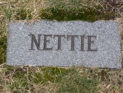

Manetta E. “Nettie” McLain Rhome
| Birth | : | 1892 West Bethel, Oxford County, Maine, USA |
| Death | : | 1962 |
| Burial | : | Forest Vale Cemetery, Jefferson, Coos County, USA |
| Coordinate | : | 44.3804800, -71.4754700 |
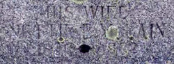
| Description | : | daughter of Cornelius "Neil" McLain and Lydia Briggs. married Julian Richard Gorman on July 4, 1920 in Berlin, NH. married in April 1946 in Saint Johnsbury, VT Alexander J. Rhome, son of Sam Rhome and Mary Fortier of Canada. Alexander died in 1956 in Lancaster, NH and is buried in Dover, NH. Note: Manetta's dates are hard to read on the stone but it looks like she died in 1962. I can't find a death record for her yet but do know she was still alive when her 2nd husband died in 1956. |
frequently asked questions (FAQ):
-
Where is Manetta E. “Nettie” McLain Rhome's memorial?
Manetta E. “Nettie” McLain Rhome's memorial is located at: Forest Vale Cemetery, Jefferson, Coos County, USA.
-
When did Manetta E. “Nettie” McLain Rhome death?
Manetta E. “Nettie” McLain Rhome death on 1962 in
-
Where are the coordinates of the Manetta E. “Nettie” McLain Rhome's memorial?
Latitude: 44.3804800
Longitude: -71.4754700
Family Members:
Spouse
Flowers:


Nearby Cemetories:
1. Forest Vale Cemetery
Jefferson, Coos County, USA
Coordinate: 44.3804800, -71.4754700
2. Applebee Family Cemetery
Jefferson, Coos County, USA
Coordinate: 44.3508300, -71.4633400
3. Starr King Cemetery
Jefferson, Coos County, USA
Coordinate: 44.4014800, -71.4424400
4. Hillside Cemetery
Jefferson, Coos County, USA
Coordinate: 44.4169000, -71.4746400
5. Black Velvet Cemetery
Jefferson, Coos County, USA
Coordinate: 44.3741670, -71.4086110
6. Colby Cemetery
Whitefield, Coos County, USA
Coordinate: 44.4018400, -71.5498100
7. Kilkenny View Cemetery
Jefferson, Coos County, USA
Coordinate: 44.4384080, -71.5146010
8. Riverton Cemetery
Jefferson, Coos County, USA
Coordinate: 44.4336200, -71.5309300
9. Wentworth-Reed Cemetery
Jefferson, Coos County, USA
Coordinate: 44.4399700, -71.5206100
10. Indian Cemetery
Jefferson, Coos County, USA
Coordinate: 44.4491500, -71.5314000
11. Straw Cemetery
Carroll, Coos County, USA
Coordinate: 44.3101300, -71.5507000
12. Balch Family Cemetery
Lancaster, Coos County, USA
Coordinate: 44.4641872, -71.5235365
13. Park Street Cemetery
Whitefield, Coos County, USA
Coordinate: 44.3737100, -71.6022000
14. Wentworth Family Cemetery
Lancaster, Coos County, USA
Coordinate: 44.4750000, -71.4763890
15. Old Cemetery
Whitefield, Coos County, USA
Coordinate: 44.3743190, -71.6106680
16. Saint Matthews Cemetery
Whitefield, Coos County, USA
Coordinate: 44.3820400, -71.6163300
17. Pine Street Cemetery
Whitefield, Coos County, USA
Coordinate: 44.3792000, -71.6175200
18. Kimball Hill Cemetery
Whitefield, Coos County, USA
Coordinate: 44.3569660, -71.6229410
19. Burns Cemetery
Whitefield, Coos County, USA
Coordinate: 44.3577200, -71.6312200
20. Number 10 Cemetery
Lancaster, Coos County, USA
Coordinate: 44.4246900, -71.6270600
21. Crawford Cemetery
Carroll, Coos County, USA
Coordinate: 44.2607680, -71.4514630
22. Saint Margaret Cemetery
Twin Mountain, Coos County, USA
Coordinate: 44.2681160, -71.5428391
23. Rosebrook Cemetery
Carroll, Coos County, USA
Coordinate: 44.2739400, -71.5709600
24. Ladd Cemetery
Dalton, Coos County, USA
Coordinate: 44.3790440, -71.6550400