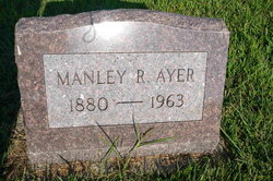
Manley Ray Ayer
| Birth | : | 4 Nov 1880 Schuyler County, Missouri, USA |
| Death | : | Jan 1963 Iowa, USA |
| Burial | : | Friendship Township Cemetery, Harbor Springs, Emmet County, USA |
| Coordinate | : | 45.5074997, -85.0366974 |
| Description | : | This information supplied by the following web site: The authors of this work is unknown, but much appreciation and gratitude go to these people for all their hard work and dedication: *********************************** mother-2-mother.com/genealogy/schuyler |
frequently asked questions (FAQ):
-
Where is Manley Ray Ayer's memorial?
Manley Ray Ayer's memorial is located at: Friendship Township Cemetery, Harbor Springs, Emmet County, USA.
-
When did Manley Ray Ayer death?
Manley Ray Ayer death on Jan 1963 in Iowa, USA
-
Where are the coordinates of the Manley Ray Ayer's memorial?
Latitude: 45.5074997
Longitude: -85.0366974
Family Members:
Parent
Siblings
Flowers:
Nearby Cemetories:
1. Friendship Township Cemetery
Harbor Springs, Emmet County, USA
Coordinate: 45.5074997, -85.0366974
2. Starr Cemetery
Stutsmanville, Emmet County, USA
Coordinate: 45.5075000, -84.9747220
3. Beran Baptist Cemetery
Harbor Springs, Emmet County, USA
Coordinate: 45.5515284, -85.0981930
4. Saint Ignatius Cemetery
Good Hart, Emmet County, USA
Coordinate: 45.5513880, -85.1155550
5. Lakeview Cemetery
Harbor Springs, Emmet County, USA
Coordinate: 45.4403000, -84.9982986
6. Holy Childhood of Jesus Cemetery
Harbor Springs, Emmet County, USA
Coordinate: 45.4387200, -84.9969500
7. Holy Childhood Indian Cemetery
Harbor Springs, Emmet County, USA
Coordinate: 45.4290656, -84.9910312
8. Brooks Cemetery
Marsh Corner, Emmet County, USA
Coordinate: 45.5692320, -84.9531560
9. Pleasantview Cemetery
Harbor Springs, Emmet County, USA
Coordinate: 45.5005989, -84.9132996
10. Readmond Township Cemetery
Good Hart, Emmet County, USA
Coordinate: 45.6018982, -85.0372009
11. Island View Cemetery
Good Hart, Emmet County, USA
Coordinate: 45.5938988, -85.0943985
12. Saint Nicholas Cemetery
Center Township, Emmet County, USA
Coordinate: 45.5928001, -84.9411011
13. Indian Cemetery
Cross Village, Emmet County, USA
Coordinate: 45.6333330, -85.0263890
14. Ayr Cemetery
Brutus, Emmet County, USA
Coordinate: 45.5074997, -84.8527985
15. Holy Cross Cemetery
Cross Village, Emmet County, USA
Coordinate: 45.6399994, -85.0180969
16. Cross Village Township Cemetery
Cross Village, Emmet County, USA
Coordinate: 45.6402830, -85.0181620
17. Father Weikamp Cemetery
Cross Village, Emmet County, USA
Coordinate: 45.6434780, -85.0330910
18. Saint Francis Solanus Indian Mission Cemetery
Petoskey, Emmet County, USA
Coordinate: 45.3753120, -84.9674140
19. Little Traverse Township Cemetery
Harbor Springs, Emmet County, USA
Coordinate: 45.4357986, -84.8630981
20. Saint Francis Cemetery
Petoskey, Emmet County, USA
Coordinate: 45.3703130, -84.9799830
21. Bay View Memorial Garden
Bay View, Emmet County, USA
Coordinate: 45.3865300, -84.9282900
22. Greenwood Cemetery
Van, Emmet County, USA
Coordinate: 45.6035309, -84.8834610
23. Greenwood Cemetery
Petoskey, Emmet County, USA
Coordinate: 45.3679276, -84.9753571
24. Sacramentine Monastery Cemetery
Petoskey, Emmet County, USA
Coordinate: 45.4102020, -84.8670610

