Manuel "Mike" Rel
| Birth | : | 10 Apr 1919 Fruitdale, Butte County, South Dakota, USA |
| Death | : | 10 Nov 1984 Wenatchee, Chelan County, Washington, USA |
| Burial | : | Powhatan Community Cemetery, Powhatan, Powhatan County, USA |
| Coordinate | : | 37.5461090, -77.9223290 |
| Plot | : | North Fraternal Row16 STBLK14 LN5 |
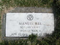
| Inscription | : | SGT US ARMY WW II |
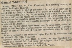
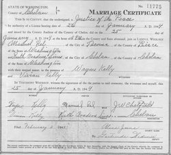
| Description | : | Manuel "Mike" Rel, 65, East Wenatchee, died Saturday evening at Central Washington Hospital. He was born April 10, 1919, at Fruitdale, SD., and at an early age he moved with his family to Worland, Wyo., where he attended schools. In 1939, he entered the US Army, serving during World War II. Mr. Rel spent two and a half years in Alaska and was transferred to Fort Benning, Ga., where he attended parachute school. On Jan. 25, 1944, he married Ruth O. Sines at Chelan. Mr. Rel was honorably discharged in 1945 at which time he returned to Chelan. He worked... Read More |
frequently asked questions (FAQ):
-
Where is Manuel "Mike" Rel's memorial?
Manuel "Mike" Rel's memorial is located at: Powhatan Community Cemetery, Powhatan, Powhatan County, USA.
-
When did Manuel "Mike" Rel death?
Manuel "Mike" Rel death on 10 Nov 1984 in Wenatchee, Chelan County, Washington, USA
-
Where are the coordinates of the Manuel "Mike" Rel's memorial?
Latitude: 37.5461090
Longitude: -77.9223290
Family Members:
Spouse
Children
Flowers:
Nearby Cemetories:
1. Powhatan Community Cemetery
Powhatan, Powhatan County, USA
Coordinate: 37.5461090, -77.9223290
2. Hollywood Baptist Church Cemetery
Powhatan, Powhatan County, USA
Coordinate: 37.5485180, -77.9228070
3. Powhatan Courthouse Lawn
Powhatan, Powhatan County, USA
Coordinate: 37.5417060, -77.9178190
4. Emmanuel Episcopal Church Cemetery
Powhatan, Powhatan County, USA
Coordinate: 37.5516470, -77.9429150
5. Powhatan Mennonite Church Cemetery
Powhatan, Powhatan County, USA
Coordinate: 37.5357180, -77.8951930
6. Greenbrier Baptist Church Cemetery
Powhatan, Powhatan County, USA
Coordinate: 37.5632900, -77.9439640
7. Bridge Church Cemetery
Powhatan, Powhatan County, USA
Coordinate: 37.5611801, -77.8804474
8. Siddons Cemetery
Powhatan County, USA
Coordinate: 37.5686390, -77.9608475
9. Peterville Cemetery
Powhatan County, USA
Coordinate: 37.5643997, -77.9646988
10. Salmon Family Cemetery
Powhatan, Powhatan County, USA
Coordinate: 37.5471640, -77.9711170
11. Bates Family Cemetery
Powhatan County, USA
Coordinate: 37.5237500, -77.9634900
12. Hague Family Cemetery
Powhatan County, USA
Coordinate: 37.5237700, -77.9635900
13. Pine Hill Baptist Church Cemetery
Macon, Powhatan County, USA
Coordinate: 37.5089100, -77.9566060
14. Bondurant Family Cemetery
Powhatan, Powhatan County, USA
Coordinate: 37.5688300, -77.8550600
15. Mount Calvary Baptist Church Cemetery
Powhatan, Powhatan County, USA
Coordinate: 37.5297390, -77.8499830
16. Red Lane Baptist Church Cemetery
Flat Rock, Powhatan County, USA
Coordinate: 37.5348015, -77.8482971
17. Hickman-Hickmon & Criss Family Cemetery
Macon, Powhatan County, USA
Coordinate: 37.5122660, -77.9850680
18. Hewitt Family Cemetery
Powhatan, Powhatan County, USA
Coordinate: 37.5871310, -77.9822970
19. Hening Cemetery
Jefferson, Powhatan County, USA
Coordinate: 37.6095000, -77.9219500
20. Amos Family Cemetery
Powhatan, Powhatan County, USA
Coordinate: 37.5141500, -77.8515300
21. Fine Creek Church Cemetery
Fine Creek Mills, Powhatan County, USA
Coordinate: 37.6118430, -77.9003510
22. Cosby Family Cemetery
Powhatan County, USA
Coordinate: 37.6118640, -77.9562810
23. Providence Presbyterian Church Cemetery
Powhatan, Powhatan County, USA
Coordinate: 37.5249760, -78.0081250
24. Mount Zion Baptist Church Cemetery
Powhatan, Powhatan County, USA
Coordinate: 37.5630360, -78.0125680


