
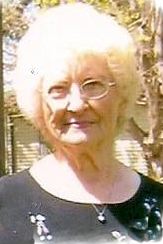

Marcella Amelia Redl Clark
| Birth | : | 11 Jan 1928 Newcastle, Dixon County, Nebraska, USA |
| Death | : | 8 Jan 2014 Spencer, Clay County, Iowa, USA |
| Burial | : | North Lawn Cemetery, Spencer, Clay County, USA |
| Coordinate | : | 43.1600000, -95.1470000 |
| Description | : | Marcella Amelia Clark, the daughter of Peter and Helen (Lukken) Redl, was born January 11, 1928 in Newcastle, NE. Her childhood years were spent in Newcastle, where she received her education, graduating in 1945. She married Ralph Clark on September 22, 1948, in Newcastle, NE. After their marriage, they owned and operated Clark's Cafe in Newcastle, where she cooked and made her state famous pies and raised her family. The couple moved to Spencer in 1967. In Spencer, she worked as a CNA at Spencer Hospital for 10 years, then at St. Luke Lutheran Home for 15 years. She and... Read More |
frequently asked questions (FAQ):
-
Where is Marcella Amelia Redl Clark's memorial?
Marcella Amelia Redl Clark's memorial is located at: North Lawn Cemetery, Spencer, Clay County, USA.
-
When did Marcella Amelia Redl Clark death?
Marcella Amelia Redl Clark death on 8 Jan 2014 in Spencer, Clay County, Iowa, USA
-
Where are the coordinates of the Marcella Amelia Redl Clark's memorial?
Latitude: 43.1600000
Longitude: -95.1470000
Family Members:
Parent

Spouse

Siblings
Children
Flowers:


Nearby Cemetories:
1. North Lawn Cemetery
Spencer, Clay County, USA
Coordinate: 43.1600000, -95.1470000
2. Dewey Readmore Books Memorial
Spencer, Clay County, USA
Coordinate: 43.1403999, -95.1443024
3. Riverside Cemetery
Spencer, Clay County, USA
Coordinate: 43.1441994, -95.1671982
4. Fairview Cemetery
Clay County, USA
Coordinate: 43.1899986, -95.0800018
5. Evergreen Cemetery
Clay County, USA
Coordinate: 43.2052994, -95.2086029
6. Dickens Cemetery
Dickens, Clay County, USA
Coordinate: 43.1280000, -95.0155000
7. Swedish Lutheran Cemetery
Royal, Clay County, USA
Coordinate: 43.0683000, -95.2350000
8. Little Sioux Lutheran Cemetery
Milford, Dickinson County, USA
Coordinate: 43.2702065, -95.2109528
9. Rosehill Cemetery
Clay County, USA
Coordinate: 43.0368996, -95.0919037
10. First Reformed Cemetery
Clay County, USA
Coordinate: 43.2399500, -95.2889000
11. Lone Tree Cemetery
Everly, Clay County, USA
Coordinate: 43.1411018, -95.3347015
12. Milford Cemetery
Milford, Dickinson County, USA
Coordinate: 43.3092003, -95.1481018
13. Lincoln Cemetery
Rossie, Clay County, USA
Coordinate: 43.0111008, -95.2313995
14. Calvary Cemetery
Milford, Dickinson County, USA
Coordinate: 43.3213997, -95.1688995
15. Logan Township Cemetery
Clay County, USA
Coordinate: 43.0489006, -94.9747009
16. Liberty Cemetery
Greenville, Clay County, USA
Coordinate: 42.9897003, -95.1417007
17. Willow Creek Cemetery
Royal, Clay County, USA
Coordinate: 43.0214005, -95.2885971
18. Clay Center Cemetery
Royal, Clay County, USA
Coordinate: 43.0410995, -95.3272018
19. TriMello Cemetery
Royal, Clay County, USA
Coordinate: 43.0682983, -95.3728027
20. Crown Hill Cemetery
Ruthven, Palo Alto County, USA
Coordinate: 43.1328011, -94.8878021
21. Calvary Cemetery
Ruthven, Palo Alto County, USA
Coordinate: 43.1314011, -94.8869019
22. Zion Methodist Cemetery
Clay County, USA
Coordinate: 42.9808006, -95.2497025
23. Westport Cemetery
Dickinson County, USA
Coordinate: 43.3130989, -95.3289032
24. Okoboji Cemetery
Arnolds Park, Dickinson County, USA
Coordinate: 43.3649406, -95.1303558