
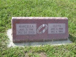

Marcella Mae Mentha Robbins
| Birth | : | 5 Aug 1916 Wheaton, Pottawatomie County, Kansas, USA |
| Death | : | 20 Dec 2000 Centralia, Nemaha County, Kansas, USA |
| Burial | : | Ashland Cemetery, Ashland, Boyd County, USA |
| Coordinate | : | 38.4597850, -82.6313980 |
| Plot | : | BLOCK II |
| Description | : | From The Wyoming Tribune Eagle December 22, 2000 Marcella Mae Robbins, 84, of Onaga, Kan., died Dec. 20 in Centralia, Kan. She was born Aug. 5, 1916, near Wheaton, Kan., to Marcel E. and Mae Ladner Mentha. She lived in Cheyenne from 1956-75. Mrs. Robbins was a sales clerk at the Russell Stover Candy Store and Fowlers Department Store in Cheyenne. She retired in 1968. She was a member of the First Congregational United Church of Christ in Onaga and a former member and treasurer of the Ladies Aid at the church. She also was a... Read More |
frequently asked questions (FAQ):
-
Where is Marcella Mae Mentha Robbins's memorial?
Marcella Mae Mentha Robbins's memorial is located at: Ashland Cemetery, Ashland, Boyd County, USA.
-
When did Marcella Mae Mentha Robbins death?
Marcella Mae Mentha Robbins death on 20 Dec 2000 in Centralia, Nemaha County, Kansas, USA
-
Where are the coordinates of the Marcella Mae Mentha Robbins's memorial?
Latitude: 38.4597850
Longitude: -82.6313980
Family Members:
Parent

Spouse

Children
Flowers:


Nearby Cemetories:
1. Ashland Cemetery
Ashland, Boyd County, USA
Coordinate: 38.4597850, -82.6313980
2. Jones Cemetery
Ashland, Boyd County, USA
Coordinate: 38.4463890, -82.6277780
3. Gallaher Cemetery
Ashland, Boyd County, USA
Coordinate: 38.4622820, -82.6524240
4. Bethesda Cemetery
Ashland, Boyd County, USA
Coordinate: 38.4721500, -82.6491510
5. Brickey Cemetery
Boyd County, USA
Coordinate: 38.4563900, -82.6577800
6. Calvary Catholic Cemetery
Ashland, Boyd County, USA
Coordinate: 38.4742012, -82.6519012
7. Brubaker Cemetery
Perry Township, Lawrence County, USA
Coordinate: 38.4604840, -82.6021710
8. Golden Oaks Memorial Gardens
Ashland, Boyd County, USA
Coordinate: 38.4383011, -82.6166992
9. Beech Grove Cemetery
Ashland, Boyd County, USA
Coordinate: 38.4802610, -82.6483320
10. Pollard Cemetery
Ashland, Boyd County, USA
Coordinate: 38.4717920, -82.6617380
11. Rose Hill Burial Park and Mausoleum
Ashland, Boyd County, USA
Coordinate: 38.4557991, -82.6718979
12. Crabtree Family Cemetery
Kitts Hill, Lawrence County, USA
Coordinate: 38.4907280, -82.6183990
13. Allen-Smallwood Cemetery
Boyd County, USA
Coordinate: 38.4625772, -82.6754914
14. Warner Cemetery
Catlettsburg, Boyd County, USA
Coordinate: 38.4236110, -82.6430560
15. McCoy Cemetery
Perry Township, Lawrence County, USA
Coordinate: 38.4473740, -82.5859400
16. Walker Cemetery
Catlettsburg, Boyd County, USA
Coordinate: 38.4227780, -82.6161110
17. Zoar Cemetery
Coal Grove, Lawrence County, USA
Coordinate: 38.5010986, -82.6280975
18. Winslow Cemetery
Ashland, Boyd County, USA
Coordinate: 38.4475900, -82.6821680
19. Highland Memorial Gardens
South Point, Lawrence County, USA
Coordinate: 38.4423000, -82.5821000
20. Barnett Cemetery
Catlettsburg, Boyd County, USA
Coordinate: 38.4180550, -82.6166660
21. Cumpston Cemetery
Catlettsburg, Boyd County, USA
Coordinate: 38.4191580, -82.6508480
22. Neal-Rice Cemetery
Boyd County, USA
Coordinate: 38.4161111, -82.6333333
23. Newton Cemetery
Coal Grove, Lawrence County, USA
Coordinate: 38.5024986, -82.6492004
24. Eads Cemetery
Catlettsburg, Boyd County, USA
Coordinate: 38.4155560, -82.6476280