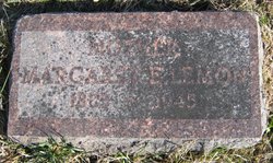
Margaret Ellen Sells Lemon
| Birth | : | 29 Oct 1869 Nodaway County, Missouri, USA |
| Death | : | 10 May 1945 Maryville, Nodaway County, Missouri, USA |
| Burial | : | Trinity-Bergen Cemetery, Starkweather, Ramsey County, USA |
| Coordinate | : | 48.3851180, -98.9264180 |
| Plot | : | Second Addition (2) Row 9, n-s |
| Inscription | : | Mother |
frequently asked questions (FAQ):
-
Where is Margaret Ellen Sells Lemon's memorial?
Margaret Ellen Sells Lemon's memorial is located at: Trinity-Bergen Cemetery, Starkweather, Ramsey County, USA.
-
When did Margaret Ellen Sells Lemon death?
Margaret Ellen Sells Lemon death on 10 May 1945 in Maryville, Nodaway County, Missouri, USA
-
Where are the coordinates of the Margaret Ellen Sells Lemon's memorial?
Latitude: 48.3851180
Longitude: -98.9264180
Family Members:
Parent
Spouse
Siblings
Children
Flowers:
Nearby Cemetories:
1. Trinity-Bergen Cemetery
Starkweather, Ramsey County, USA
Coordinate: 48.3851180, -98.9264180
2. Saints Peter and Paul Catholic Cemetery
Ramsey County, USA
Coordinate: 48.3320500, -98.8343920
3. Trinity Bergen Lutheran Cemetery
Starkweather, Ramsey County, USA
Coordinate: 48.4556208, -98.8608619
4. Calvary Catholic Cemetery
Starkweather, Ramsey County, USA
Coordinate: 48.4566994, -98.8619003
5. Coolin Cemetery
Coolin Township, Towner County, USA
Coordinate: 48.4637800, -98.9924530
6. Chain Lake Lutheran Cemetery
Garske, Ramsey County, USA
Coordinate: 48.3254100, -99.0389000
7. Webster Cemetery
Ramsey County, USA
Coordinate: 48.2813988, -98.9180984
8. Sons Of Jacob Cemetery
Garske, Ramsey County, USA
Coordinate: 48.3890500, -98.7575100
9. Almlie Cemetery
Ramsey County, USA
Coordinate: 48.3344002, -99.0914001
10. Scandinavia Cemetery
Webster, Ramsey County, USA
Coordinate: 48.3249660, -98.7438332
11. Salem Cemetery
Seivert Township, Cavalier County, USA
Coordinate: 48.5447006, -98.9439011
12. Olson Cemetery
Maza, Towner County, USA
Coordinate: 48.4291992, -99.2097015
13. Sacred Heart Catholic Cemetery
Cando, Towner County, USA
Coordinate: 48.4857990, -99.1869020
14. IOOF Cemetery
Cando, Towner County, USA
Coordinate: 48.4864006, -99.1893997
15. Saint Paul Cemetery
Ramsey County, USA
Coordinate: 48.2164001, -99.1138992
16. Presbyterian Cemetery
Ramsey County, USA
Coordinate: 48.2235985, -99.1371994
17. Churchs Ferry Cemetery
Churchs Ferry, Ramsey County, USA
Coordinate: 48.2522011, -99.1883011
18. Grand Harbor Cemetery
Ramsey County, USA
Coordinate: 48.1585999, -98.9897003
19. Bethel Cemetery
Cato Township, Ramsey County, USA
Coordinate: 48.3032990, -98.5942001
20. Antiochia Cemetery
Benson County, USA
Coordinate: 48.2242310, -99.2136320
21. Egeland Union Cemetery
Egeland, Towner County, USA
Coordinate: 48.6171989, -99.0841980
22. Storlie Cemetery
Storlie Township, Cavalier County, USA
Coordinate: 48.5732994, -98.6544037
23. Schneider Farm Cemetery
Crary, Ramsey County, USA
Coordinate: 48.2519798, -98.5887000
24. Saint Benedicts Cemetery
Crary, Ramsey County, USA
Coordinate: 48.1932880, -98.6588680


