
Margaret “Peggy” Burnside
| Birth | : | 4 Oct 1766 Londonderry, Rockingham County, New Hampshire, USA |
| Death | : | 7 Jul 1830 Wells River, Orange County, Vermont, USA |
| Burial | : | Wells River Cemetery, Wells River, Orange County, USA |
| Coordinate | : | 44.1535988, -72.0547028 |
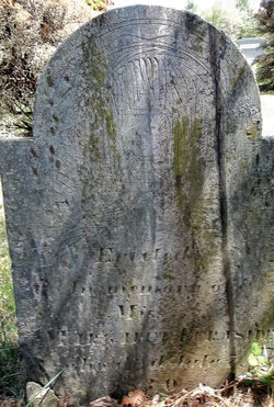
| Inscription | : | "Erected in memory of Miss Margaret Burnside, died July 7th, 1830." |
| Description | : | Note: This marker is in the farthest section of the cemetery. These graves were moved from the original Wells River Village cemetery after this cemetery was opened in 1867. Some stones are not legible. Margaret ("Peggy") Burnside was a governess and a master tailor, having been employed by several wealthy families in Wells River, VT for more than 40 years until her death. Contributor: Ryan Dariush Wood (48735128) |
frequently asked questions (FAQ):
-
Where is Margaret “Peggy” Burnside's memorial?
Margaret “Peggy” Burnside's memorial is located at: Wells River Cemetery, Wells River, Orange County, USA.
-
When did Margaret “Peggy” Burnside death?
Margaret “Peggy” Burnside death on 7 Jul 1830 in Wells River, Orange County, Vermont, USA
-
Where are the coordinates of the Margaret “Peggy” Burnside's memorial?
Latitude: 44.1535988
Longitude: -72.0547028
Family Members:
Parent
Siblings

Flowers:


Nearby Cemetories:
1. Wells River Cemetery
Wells River, Orange County, USA
Coordinate: 44.1535988, -72.0547028
2. Carbee Cemetery
Bath, Grafton County, USA
Coordinate: 44.1724640, -72.0466980
3. Boltonville Cemetery
Boltonville, Orange County, USA
Coordinate: 44.1575012, -72.0877991
4. Saint Joseph Cemetery
Bath, Grafton County, USA
Coordinate: 44.1803017, -72.0524979
5. Pine Grove Cemetery
Woodsville, Grafton County, USA
Coordinate: 44.1380997, -72.0188980
6. Carbee District Cemetery
Bath, Grafton County, USA
Coordinate: 44.1881040, -72.0521310
7. Horse Meadow Cemetery
North Haverhill, Grafton County, USA
Coordinate: 44.1068880, -72.0405500
8. Horse Meadow Annex Cemetery
North Haverhill, Grafton County, USA
Coordinate: 44.1056820, -72.0408260
9. Old Scotch Cemetery
Ryegate, Caledonia County, USA
Coordinate: 44.1969000, -72.0928600
10. West Bath Cemetery
Bath, Grafton County, USA
Coordinate: 44.1750930, -71.9865080
11. Bedel Cemetery
Bath, Grafton County, USA
Coordinate: 44.2075000, -72.0455560
12. Pinehurst Cemetery
Ryegate, Caledonia County, USA
Coordinate: 44.1856003, -72.1280975
13. Manchester Family Cemetery
Ryegate, Caledonia County, USA
Coordinate: 44.2153625, -72.0713120
14. Jefferson Hill Cemetery
Newbury, Orange County, USA
Coordinate: 44.1658400, -72.1424200
15. Hillside Cemetery
South Ryegate, Caledonia County, USA
Coordinate: 44.1846800, -72.1336200
16. Oxbow Cemetery
Newbury, Orange County, USA
Coordinate: 44.0881830, -72.0486670
17. Blue Mountain Cemetery
Ryegate Corner, Caledonia County, USA
Coordinate: 44.2081000, -72.1058700
18. Bath Village Cemetery
Bath, Grafton County, USA
Coordinate: 44.1693500, -71.9617800
19. Town House Cemetery
Newbury Center, Orange County, USA
Coordinate: 44.1066322, -72.1256943
20. Swiftwater Cemetery
Bath, Grafton County, USA
Coordinate: 44.1303400, -71.9574300
21. Upper Smith Road Cemetery
Bath, Grafton County, USA
Coordinate: 44.2202780, -72.0075000
22. Abbott Cemetery
North Haverhill, Grafton County, USA
Coordinate: 44.0821730, -72.0186420
23. Pettyboro District Cemetery
Pettyboro, Grafton County, USA
Coordinate: 44.2038310, -71.9620880
24. Center Haverhill Cemetery
Center Haverhill, Grafton County, USA
Coordinate: 44.0770650, -71.9868740