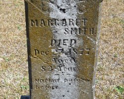
Margaret “Peggy” Stafford Smith
| Birth | : | 27 Aug 1796 Pee Dee, Marion County, South Carolina, USA |
| Death | : | 25 Dec 1877 Marion County, South Carolina, USA |
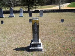
| Burial | : | Carolina Presbyterian Church Cemetery, Carolina, Dillon County, USA |
| Coordinate | : | 34.5736008, -79.4385986 |
| Inscription | : | Aged 82 Years Not lost but gone before. |
| Description | : | Margaret was the daughter of immigrant Neill Stafford from Kintyre, Argyll & Bute, Scotland who married Rosanna McNeill, a descendant of the Argyll Colony of Cape Fear. Her father bought land on the Persimmon Branch of the Little Pee Dee River in what was then Marion District of South Carolina. On 24 August 1863 Margaret had the sad task of filing for the pay due to her deceased son Sgt. Neill Smith who was wounded in the head and body in the Battle at Gaines Mill & died 05 July 1862 at Chimborazo Hospital in Richmond, Virginia. The... Read More |
frequently asked questions (FAQ):
-
Where is Margaret “Peggy” Stafford Smith's memorial?
Margaret “Peggy” Stafford Smith's memorial is located at: Carolina Presbyterian Church Cemetery, Carolina, Dillon County, USA.
-
When did Margaret “Peggy” Stafford Smith death?
Margaret “Peggy” Stafford Smith death on 25 Dec 1877 in Marion County, South Carolina, USA
-
Where are the coordinates of the Margaret “Peggy” Stafford Smith's memorial?
Latitude: 34.5736008
Longitude: -79.4385986
Family Members:
Parent
Spouse
Siblings
Children
Flowers:
Nearby Cemetories:
1. Carolina Presbyterian Church Cemetery
Carolina, Dillon County, USA
Coordinate: 34.5736008, -79.4385986
2. Leland Grove Church Cemetery
Carolina, Dillon County, USA
Coordinate: 34.5841217, -79.4222107
3. New Holly United Methodist Church Cemetery
Little Rock, Dillon County, USA
Coordinate: 34.5512800, -79.4540800
4. Fairview United Methodist Church Cemetery
Hamer, Dillon County, USA
Coordinate: 34.5679970, -79.4032593
5. Billy Bethea Family Cemetery
Hamer, Dillon County, USA
Coordinate: 34.5585175, -79.4048538
6. New Zion AME Zion Church Cemetery
Judson, Dillon County, USA
Coordinate: 34.5578930, -79.4766430
7. Hunt Family Cemetery
Hamer, Dillon County, USA
Coordinate: 34.5562700, -79.4013700
8. Pee Dee Chapel Baptist Church Cemetery
Carolina, Dillon County, USA
Coordinate: 34.6074638, -79.4516678
9. Sinclair Cemetery
Sinclair Crossroads, Dillon County, USA
Coordinate: 34.5240860, -79.4622574
10. Ivey Cemetery
Tatum, Marlboro County, USA
Coordinate: 34.5985550, -79.4979030
11. Old Reedy Branch Cemetery
Clio, Marlboro County, USA
Coordinate: 34.6160300, -79.4836400
12. Reedy Branch Baptist Church
Marlboro County, USA
Coordinate: 34.6254900, -79.4757300
13. Magnolia Stateline AME Church Cemetery
Hamer, Dillon County, USA
Coordinate: 34.5445200, -79.3690400
14. Hairgrove Cemetery
Minturn, Dillon County, USA
Coordinate: 34.5107307, -79.4568176
15. John W. Stackhouse Memorial
Galavon, Dillon County, USA
Coordinate: 34.5097970, -79.4542730
16. Baker Cemetery
Dillon County, USA
Coordinate: 34.5483017, -79.3636017
17. Britt-Brock Cemetery
Clio, Marlboro County, USA
Coordinate: 34.6121670, -79.5049090
18. Red Bluff Cemetery
Clio, Marlboro County, USA
Coordinate: 34.6117783, -79.5053711
19. Daniels Chapel Cemetery
Marlboro County, USA
Coordinate: 34.6192000, -79.4993600
20. Ivy Cemetery
Clio, Marlboro County, USA
Coordinate: 34.5742530, -79.5220290
21. Oakland United Methodist Church Cemetery
Oakland Crossroads, Dillon County, USA
Coordinate: 34.5393829, -79.3651962
22. Saint Luke United Methodist Church Cemetery
Hamer, Dillon County, USA
Coordinate: 34.5263900, -79.3757200
23. Sweat Swamp Cemetery
Dillon County, USA
Coordinate: 34.5056000, -79.4122009
24. Ebenezer Memorial Garden
Marlboro County, USA
Coordinate: 34.5456009, -79.5188980

