
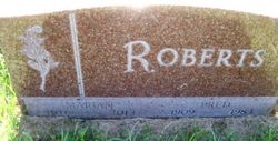

Marian Irene Nilson Roberts
| Birth | : | 17 Jan 1916 Holt County, Nebraska, USA |
| Death | : | 8 Apr 2013 Kearney, Buffalo County, Nebraska, USA |
| Burial | : | Phoenix Cemetery, Holt County, USA |
| Coordinate | : | 42.7252998, -98.7846985 |
| Plot | : | Lot 44 |
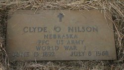
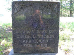
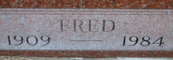
| Description | : | Marian Irene Roberts, of Kearney, NE. formerly of Atkinson, NE. died Monday, April 8, 2013, at Mount Carmel Home-Keens Memorial, Kearney, NE. Marian was born Jan. 17, 1916, on her grandfather's farm northeast of Atkinson, NE. to Clyde O. and Elsie V. Nilson. In 1933, she married Fred Roberts. He died in 1984. Survivors are: son, Richard "Bud" Roberts and his wife, Betty, of Lawton, OK.; daughter, Patricia Butterfield and her husband, Floyd, of Kearney, NE.; daughter, Mickie King and her husband, Bill, of Lawton, OK.; son, Gary and his wife, Elizabeth, of Denton, TX.; daughter, Mona Scott of Frederick, CO.;... Read More |
frequently asked questions (FAQ):
-
Where is Marian Irene Nilson Roberts's memorial?
Marian Irene Nilson Roberts's memorial is located at: Phoenix Cemetery, Holt County, USA.
-
When did Marian Irene Nilson Roberts death?
Marian Irene Nilson Roberts death on 8 Apr 2013 in Kearney, Buffalo County, Nebraska, USA
-
Where are the coordinates of the Marian Irene Nilson Roberts's memorial?
Latitude: 42.7252998
Longitude: -98.7846985
Family Members:
Parent
Spouse
Children
Flowers:


Nearby Cemetories:
1. Phoenix Cemetery
Holt County, USA
Coordinate: 42.7252998, -98.7846985
2. Sunny View Cemetery
Holt County, USA
Coordinate: 42.7258760, -98.8533750
3. Catalpa Grove Cemetery
Catalpa, Holt County, USA
Coordinate: 42.6522800, -98.8435670
4. Celia Cemetery
Holt County, USA
Coordinate: 42.6958008, -98.9313965
5. Pleasant Valley Cemetery
Holt County, USA
Coordinate: 42.6818830, -98.6389230
6. Anson Cemetery
Atkinson, Holt County, USA
Coordinate: 42.6083650, -98.7985300
7. Overlook Cemetery
Boyd County, USA
Coordinate: 42.8138890, -98.6442642
8. Mennonite Cemetery
O'Neill, Holt County, USA
Coordinate: 42.5960000, -98.7170000
9. Union Cemetery
Spencer, Boyd County, USA
Coordinate: 42.8602982, -98.7018967
10. Black Bird Cemetery
Holt County, USA
Coordinate: 42.6241220, -98.6350960
11. Devil's Gulch Ranch Cemetery
Spencer, Boyd County, USA
Coordinate: 42.8565316, -98.6871239
12. Paddock Cemetery
Midway, Holt County, USA
Coordinate: 42.6834380, -98.5887760
13. Wooden Shoe Cemetery
Atkinson, Holt County, USA
Coordinate: 42.6164930, -98.9320870
14. Saint Marys Cemetery
Spencer, Boyd County, USA
Coordinate: 42.8669014, -98.6980972
15. Bohemian National Cemetery
Spencer, Boyd County, USA
Coordinate: 42.8713989, -98.7127991
16. Jansen Pioneer Cemetery
Atkinson, Holt County, USA
Coordinate: 42.6087040, -98.9327960
17. Old Paddock Cemetery
Paddock, Holt County, USA
Coordinate: 42.7705000, -98.5509000
18. Bristow Cemetery
Bristow, Boyd County, USA
Coordinate: 42.8321991, -98.5856018
19. Immanuel Lutheran Cemetery
Butte, Boyd County, USA
Coordinate: 42.9006004, -98.8497009
20. Adams Cemetery
Holt County, USA
Coordinate: 42.8706000, -98.9694500
21. Old Immanuel Cemetery
Spencer, Boyd County, USA
Coordinate: 42.9006004, -98.6528015
22. Prospect Hill Cemetery
Opportunity, Holt County, USA
Coordinate: 42.5966700, -98.5740800
23. Saints Peter and Paul Cemetery
Butte, Boyd County, USA
Coordinate: 42.9221992, -98.8593979
24. Scottville Cemetery
O'Neill, Holt County, USA
Coordinate: 42.6834120, -98.5120140