
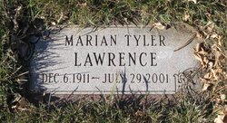
Marian O'Neil Lawrence
| Birth | : | 6 Dec 1911 Glenwood City, St. Croix County, Wisconsin, USA |
| Death | : | 29 Jul 2001 Havre, Hill County, Montana, USA |
| Burial | : | Big Sandy Cemetery, Big Sandy, Chouteau County, USA |
| Coordinate | : | 48.1801170, -110.1207500 |
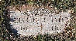
| Description | : | Obit from Find A Grave Contributor "Cara": Havre Daily News (MT), 31 Jul 2001 BIG SANDY - Marion C. Lawrence, 89, Big Sandy, died Sunday, July 29, 2001, at Havre. Cremation has taken place. A memorial service will be 10 a.m. Thursday at Big Sandy Methodist Church, with burial to follow in Big Sandy Cemetery. A luncheon at the church will follow the services. Lawrence was born Dec. 6, 1911 in Glenwood City, Wis. She attended country school in Chouteau and Hill counties and graduated from Big Sandy High School in 1930. She married Charles Tyler on Sept. 27, 1930. They lived... Read More |
frequently asked questions (FAQ):
-
Where is Marian O'Neil Lawrence's memorial?
Marian O'Neil Lawrence's memorial is located at: Big Sandy Cemetery, Big Sandy, Chouteau County, USA.
-
When did Marian O'Neil Lawrence death?
Marian O'Neil Lawrence death on 29 Jul 2001 in Havre, Hill County, Montana, USA
-
Where are the coordinates of the Marian O'Neil Lawrence's memorial?
Latitude: 48.1801170
Longitude: -110.1207500
Family Members:
Spouse
Flowers:


Nearby Cemetories:
1. Big Sandy Cemetery
Big Sandy, Chouteau County, USA
Coordinate: 48.1801170, -110.1207500
2. Box Elder Cemetery
Box Elder, Hill County, USA
Coordinate: 48.3274000, -110.0095000
3. Kenilworth Cemetery
Chouteau County, USA
Coordinate: 48.2192001, -110.4188995
4. Rocky Boy Cemetery
Rocky Boy, Hill County, USA
Coordinate: 48.2572410, -109.7923690
5. Rocky Boy Gravel Cemetery
Rocky Boy, Hill County, USA
Coordinate: 48.2427720, -109.7596500
6. Cottonwood Lutheran Church Cemetery
Havre, Hill County, USA
Coordinate: 48.4545000, -110.1748000
7. Gildford Hill County Cemetery
Gildford, Hill County, USA
Coordinate: 48.5778008, -110.2957993
8. Clear Lake Cemetery
Chouteau County, USA
Coordinate: 47.7731018, -110.2514038
9. Hingham Union Cemetery
Hingham, Hill County, USA
Coordinate: 48.5601570, -110.4178980
10. Sunset Garden Park
Havre, Hill County, USA
Coordinate: 48.5531006, -109.8019028
11. Graceville Cemetery
Chouteau County, USA
Coordinate: 47.7505989, -110.0875015
12. Hungry Hollow Cemetery
Blaine County, USA
Coordinate: 48.2103004, -109.4677963
13. Highland Cemetery
Havre, Hill County, USA
Coordinate: 48.5463982, -109.6900024
14. Mount Hope Cemetery
Havre, Hill County, USA
Coordinate: 48.5540000, -109.7050000
15. Calvary Cemetery
Havre, Hill County, USA
Coordinate: 48.5457000, -109.6883000
16. Rudyard Cemetery
Rudyard, Hill County, USA
Coordinate: 48.5659500, -110.5390000
17. Riverside Cemetery
Fort Benton, Chouteau County, USA
Coordinate: 47.8402330, -110.6408830
18. Old Shep Gravesite
Fort Benton, Chouteau County, USA
Coordinate: 47.8369000, -110.6557000
19. Milk River Valley Church Graveyard
Hill County, USA
Coordinate: 48.6787180, -110.2261080
20. Museum of the Upper Missouri
Fort Benton, Chouteau County, USA
Coordinate: 47.8207000, -110.6642000
21. Inverness Cemetery
Hill County, USA
Coordinate: 48.5531340, -110.6688450
22. Grainbelt Cemetery
Hill County, USA
Coordinate: 48.6828003, -109.8657990
23. Montague Cemetery
Chouteau County, USA
Coordinate: 47.6783000, -110.4670000
24. North Havre Lutheran Church Graveyard (Defunct)
Havre, Hill County, USA
Coordinate: 48.6538903, -109.6815870