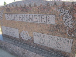
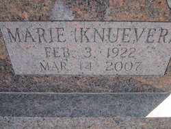
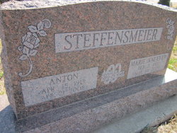
Marie A. Knuever Steffensmeier
| Birth | : | 3 Feb 1922 Monterey, Cuming County, Nebraska, USA |
| Death | : | 14 Mar 2007 West Point, Cuming County, Nebraska, USA |
| Burial | : | Pyrmont Cemetery, Pyrmont, Montgomery County, USA |
| Coordinate | : | 39.8157997, -84.4618988 |
| Description | : | Son of Joseph Knuever and Elizabeth Ermels Throener Knuever and attended St. Boniface Catholic School. Marie worked as a hired girl before her September 25, 1945 marriage to Anton Steffensmeier at St. Boniface Catholic Church. The couple farmed near Snyder, where Marie was an active farm wife, retiring to Dodge in 1981. The couple moved to St. Joseph's Retirement Community in West Point in April of 2005. Marie was a member of St. Wenceslaus Catholic Church, Altar Society, and V.F.W. Auxiliary. She enjoyed volunteering at Parkview Nursing Home in Dodge. Survivors include her husband, Anton, of West Point, son Richard (Shadda) Steffensmeier... Read More |
frequently asked questions (FAQ):
-
Where is Marie A. Knuever Steffensmeier's memorial?
Marie A. Knuever Steffensmeier's memorial is located at: Pyrmont Cemetery, Pyrmont, Montgomery County, USA.
-
When did Marie A. Knuever Steffensmeier death?
Marie A. Knuever Steffensmeier death on 14 Mar 2007 in West Point, Cuming County, Nebraska, USA
-
Where are the coordinates of the Marie A. Knuever Steffensmeier's memorial?
Latitude: 39.8157997
Longitude: -84.4618988
Family Members:
Spouse
Children
Flowers:
Nearby Cemetories:
1. Pyrmont Cemetery
Pyrmont, Montgomery County, USA
Coordinate: 39.8157997, -84.4618988
2. Hansbarger Family Cemetery
Pyrmont, Montgomery County, USA
Coordinate: 39.8085360, -84.4427630
3. Shiloh Lutheran Cemetery
Twin Township, Preble County, USA
Coordinate: 39.8096230, -84.4839370
4. Hook Family Cemetery
Pyrmont, Montgomery County, USA
Coordinate: 39.8066420, -84.4398770
5. Saint Johns Evangelical Lutheran Cemetery
Lewisburg, Preble County, USA
Coordinate: 39.8385620, -84.4880680
6. Bachman Cemetery
Bachman, Montgomery County, USA
Coordinate: 39.8613620, -84.4602300
7. Landis Cemetery
Brookville, Montgomery County, USA
Coordinate: 39.8180540, -84.3987510
8. Providence Lutheran Cemetery
Montgomery County, USA
Coordinate: 39.8041760, -84.3953630
9. Arlington Cemetery
Brookville, Montgomery County, USA
Coordinate: 39.8652992, -84.4297028
10. Parish Cemetery
Arlington, Montgomery County, USA
Coordinate: 39.8660660, -84.4297028
11. Kreider Cemetery
Montgomery County, USA
Coordinate: 39.8414400, -84.3871700
12. Pleasant Hill Cemetery
Brookville, Montgomery County, USA
Coordinate: 39.8031006, -84.3807983
13. Lower Lewisburg Cemetery
Lewisburg, Preble County, USA
Coordinate: 39.8453331, -84.5369339
14. McNelly Cemetery
Hays Corner, Montgomery County, USA
Coordinate: 39.7962860, -84.3791570
15. Warvel Cemetery
New Lebanon, Montgomery County, USA
Coordinate: 39.7494010, -84.4492440
16. Pfoutz Cemetery
New Lebanon, Montgomery County, USA
Coordinate: 39.7658330, -84.4003330
17. Roselawn Cemetery
Lewisburg, Preble County, USA
Coordinate: 39.8518982, -84.5428009
18. Arnold Cemetery
Brookville, Montgomery County, USA
Coordinate: 39.8317216, -84.3705022
19. Sugar Grove Cemetery
West Alexandria, Preble County, USA
Coordinate: 39.7668991, -84.5318985
20. Old Presbyterian Cemetery
New Lexington, Preble County, USA
Coordinate: 39.7619971, -84.5307839
21. Hart Family Cemetery
New Lexington, Preble County, USA
Coordinate: 39.7851050, -84.5518290
22. Royal Oak Memorial Gardens
Brookville, Montgomery County, USA
Coordinate: 39.8698349, -84.3897476
23. Hay Cemetery
Trotwood, Montgomery County, USA
Coordinate: 39.7916220, -84.3653440
24. Miller Cemetery
Johnsville, Montgomery County, USA
Coordinate: 39.7370580, -84.4524160


