

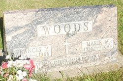
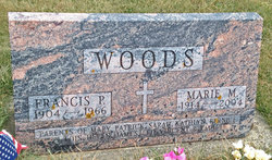
Marie M Clennon Woods
| Birth | : | 1 May 1914 West Bend, Palo Alto County, Iowa, USA |
| Death | : | 20 Jul 2004 Manchester, Delaware County, Iowa, USA |
| Burial | : | Payson City Cemetery, Payson, Utah County, USA |
| Coordinate | : | 40.0489800, -111.7199000 |
| Description | : | Marie M. Woods, 90, of Ryan died peacefully in her sleep Tuesday morning, July 20, 2004 at the Good Neighbor Home, Manchester. Funeral mass will be at 11:00 a.m. on Friday, July 23 at St. Patrick's Catholic Church in Ryan by Rev. Msgr. Ralph Simington. Friends may call from 2:00 until 8:00 p.m. on Thursday at Bohnenkamp-Murdoch Funeral Home & Cremation Service in Manchester with a scripture service at 2:00 p.m. Burial will be Calvary Cemetery, Ryan. Marie was born on May 1, 1914 in West Bend, IA the daughter of John J. and Margaret (McNally) Clennon. She attended Cathedral High School... Read More |
frequently asked questions (FAQ):
-
Where is Marie M Clennon Woods's memorial?
Marie M Clennon Woods's memorial is located at: Payson City Cemetery, Payson, Utah County, USA.
-
When did Marie M Clennon Woods death?
Marie M Clennon Woods death on 20 Jul 2004 in Manchester, Delaware County, Iowa, USA
-
Where are the coordinates of the Marie M Clennon Woods's memorial?
Latitude: 40.0489800
Longitude: -111.7199000
Family Members:
Spouse
Children
Flowers:


Nearby Cemetories:
1. Benjamin Cemetery
Benjamin, Utah County, USA
Coordinate: 40.0769005, -111.7311020
2. Salem City Cemetery
Salem, Utah County, USA
Coordinate: 40.0388985, -111.6694031
3. Find a Grave Test Cemetery - Elk Ridge
Elk Ridge, Utah County, USA
Coordinate: 40.0143435, -111.6829070
4. Blackhawk Cemetery
Spring Lake, Utah County, USA
Coordinate: 40.0070000, -111.7455700
5. Spring Lake Cemetery
Utah County, USA
Coordinate: 40.0011000, -111.7502200
6. Spanish Fork City Cemetery
Spanish Fork, Utah County, USA
Coordinate: 40.1022200, -111.6471700
7. Pioneer Heritage Cemetery
Spanish Fork, Utah County, USA
Coordinate: 40.0855000, -111.6291000
8. Santaquin City Cemetery
Santaquin, Utah County, USA
Coordinate: 39.9700012, -111.7818985
9. Genola City Cemetery
Genola, Utah County, USA
Coordinate: 39.9823000, -111.8453000
10. Evergreen Cemetery
Springville, Utah County, USA
Coordinate: 40.1399994, -111.6022034
11. Mapleton Cemetery
Mapleton, Utah County, USA
Coordinate: 40.1304300, -111.5868000
12. Joseph B Law Memorial
Mapleton, Utah County, USA
Coordinate: 40.1303700, -111.5857400
13. Historic Springville Cemetery
Springville, Utah County, USA
Coordinate: 40.1593610, -111.6148500
14. Old Rocky Ridge Cemetery
Mona, Juab County, USA
Coordinate: 39.9382300, -111.8272900
15. Rocky Ridge Cemetery
Juab County, USA
Coordinate: 39.9265200, -111.8262600
16. Goshen City Cemetery
Goshen, Utah County, USA
Coordinate: 39.9407997, -111.9019012
17. Provo City Cemetery
Provo, Utah County, USA
Coordinate: 40.2249985, -111.6444016
18. Fort Field Graveyard (Defunct)
Provo, Utah County, USA
Coordinate: 40.2354270, -111.6943720
19. Original Goshen Pioneer Cemetery
Goshen, Utah County, USA
Coordinate: 39.9527920, -111.9381170
20. Temple Hill Cemetery (Defunct)
Provo, Utah County, USA
Coordinate: 40.2452820, -111.6536140
21. Grandview Hill Pioneer Cemetery
Provo, Utah County, USA
Coordinate: 40.2579140, -111.6767170
22. Old Pioneer Cemetery
Mona, Juab County, USA
Coordinate: 39.8213997, -111.8538971
23. East Lawn Memorial Hills Cemetery
Provo, Utah County, USA
Coordinate: 40.2938995, -111.6461029
24. Mona Cemetery
Mona, Juab County, USA
Coordinate: 39.8074989, -111.8388977