
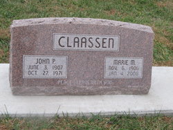
Marie M. Jantzen Claassen
| Birth | : | 6 Nov 1906 Plymouth, Jefferson County, Nebraska, USA |
| Death | : | 4 Jan 2006 Salina, Saline County, Kansas, USA |
| Burial | : | Poplar Springs Methodist Cemetery, Poplar Springs, Howard County, USA |
| Coordinate | : | 39.3457603, -77.0947800 |
| Description | : | Marie M. Claassen, 99 years of age, of Salina, Kansas formerly of Beatrice, Nebraska died at the Holiday Resort Adult Care and Rehabilitation Center in Salina on Wednesday afternoon, January 4, 2006. She was born on November 6, 1906 at Plymouth, Nebraska and attended country school, church school and then attended Hesston Academy in Hesston, Kansas for two years. She was married to John Claassen on April 27, 1933 at the First Mennonite Church of rural Beatrice, Nebraska and they lived and farmed in Gage County. She was a member of the First Mennonite Church of rural Beatrice, Nebraska where she was a member of... Read More |
frequently asked questions (FAQ):
-
Where is Marie M. Jantzen Claassen's memorial?
Marie M. Jantzen Claassen's memorial is located at: Poplar Springs Methodist Cemetery, Poplar Springs, Howard County, USA.
-
When did Marie M. Jantzen Claassen death?
Marie M. Jantzen Claassen death on 4 Jan 2006 in Salina, Saline County, Kansas, USA
-
Where are the coordinates of the Marie M. Jantzen Claassen's memorial?
Latitude: 39.3457603
Longitude: -77.0947800
Family Members:
Parent
Spouse

Siblings

Flowers:


Nearby Cemetories:
1. Poplar Springs Methodist Cemetery
Poplar Springs, Howard County, USA
Coordinate: 39.3457603, -77.0947800
2. Simpson United Methodist Church Cemetery
Poplar Springs, Howard County, USA
Coordinate: 39.3381615, -77.1016464
3. Saint Michael Catholic Cemetery
Howard County, USA
Coordinate: 39.3399136, -77.1055509
4. Saint Michael's Catholic Church Cemetery
Poplar Springs, Howard County, USA
Coordinate: 39.3383500, -77.1071100
5. England Family Cemetery
Howard County, USA
Coordinate: 39.3562700, -77.1141700
6. Liberty Baptist Church Cemetery
Lisbon, Howard County, USA
Coordinate: 39.3388443, -77.0695190
7. Pickett Family Cemetery
Howard County, USA
Coordinate: 39.3197000, -77.1151000
8. Davis - Waters Family Cemetery
Mount Airy, Carroll County, USA
Coordinate: 39.3744812, -77.1089172
9. Shipley Graveyard
Lisbon, Howard County, USA
Coordinate: 39.3302870, -77.0594130
10. Warfield Family Cemetery
Woodbine, Howard County, USA
Coordinate: 39.2951500, -77.0971400
11. Morgan Chapel United Methodist Church Cemetery
Woodbine, Carroll County, USA
Coordinate: 39.3871700, -77.0554700
12. Daisy United Methodist Church Cemetery
Lisbon, Howard County, USA
Coordinate: 39.2989883, -77.0649796
13. Howard Chapel Cemetery
Howard County, USA
Coordinate: 39.3178100, -77.1581800
14. Pine Grove Cemetery
Mount Airy, Carroll County, USA
Coordinate: 39.3718681, -77.1599426
15. Saint James Episcopal Church Memorial Garden
Mount Airy, Carroll County, USA
Coordinate: 39.3887300, -77.1430700
16. Mount Olive United Methodist Church Cemetery
Mount Airy, Carroll County, USA
Coordinate: 39.4032000, -77.0986000
17. Crapster Family Cemetery
Woodbine, Howard County, USA
Coordinate: 39.2906210, -77.1209240
18. Bushy Park Community Cemetery
Woodbine, Howard County, USA
Coordinate: 39.3163000, -77.0281670
19. Davis Family Cemetery #1
Mount Airy, Carroll County, USA
Coordinate: 39.4100037, -77.0983200
20. France Family Cemetery
Glenwood, Howard County, USA
Coordinate: 39.3090900, -77.0211700
21. Harrisville Chapel Cemetery
Mount Airy, Carroll County, USA
Coordinate: 39.4089640, -77.1285130
22. Calvary Baptist Church Cemetery
Mount Airy, Frederick County, USA
Coordinate: 39.3671500, -77.1799900
23. William Harrison Hilton Farm
Bootjack, Montgomery County, USA
Coordinate: 39.2839580, -77.1449240
24. Oak Grove Cemetery
Glenwood, Howard County, USA
Coordinate: 39.2949200, -77.0251500