
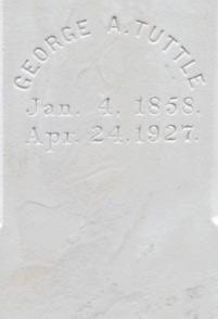
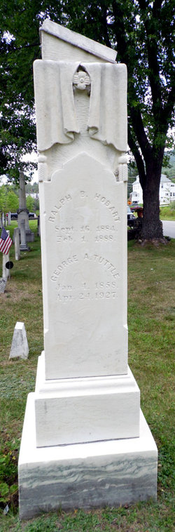
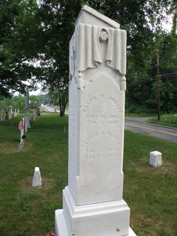
Marion Etta “Mary” Stalbird Tuttle
| Birth | : | 2 Jun 1860 Jefferson, Coos County, New Hampshire, USA |
| Death | : | 25 Apr 1927 Gilmanton, Belknap County, New Hampshire, USA |
| Burial | : | Hillside Cemetery, Jefferson, Coos County, USA |
| Coordinate | : | 44.4169000, -71.4746400 |
| Description | : | "Although Marion died and was buried just 4 days after her husband, her name didn't get put on his headstone, even though there was a space below his for her information." |
frequently asked questions (FAQ):
-
Where is Marion Etta “Mary” Stalbird Tuttle's memorial?
Marion Etta “Mary” Stalbird Tuttle's memorial is located at: Hillside Cemetery, Jefferson, Coos County, USA.
-
When did Marion Etta “Mary” Stalbird Tuttle death?
Marion Etta “Mary” Stalbird Tuttle death on 25 Apr 1927 in Gilmanton, Belknap County, New Hampshire, USA
-
Where are the coordinates of the Marion Etta “Mary” Stalbird Tuttle's memorial?
Latitude: 44.4169000
Longitude: -71.4746400
Family Members:
Parent
Spouse
Siblings
Flowers:


Nearby Cemetories:
1. Hillside Cemetery
Jefferson, Coos County, USA
Coordinate: 44.4169000, -71.4746400
2. Starr King Cemetery
Jefferson, Coos County, USA
Coordinate: 44.4014800, -71.4424400
3. Kilkenny View Cemetery
Jefferson, Coos County, USA
Coordinate: 44.4384080, -71.5146010
4. Forest Vale Cemetery
Jefferson, Coos County, USA
Coordinate: 44.3804800, -71.4754700
5. Wentworth-Reed Cemetery
Jefferson, Coos County, USA
Coordinate: 44.4399700, -71.5206100
6. Riverton Cemetery
Jefferson, Coos County, USA
Coordinate: 44.4336200, -71.5309300
7. Indian Cemetery
Jefferson, Coos County, USA
Coordinate: 44.4491500, -71.5314000
8. Colby Cemetery
Whitefield, Coos County, USA
Coordinate: 44.4018400, -71.5498100
9. Wentworth Family Cemetery
Lancaster, Coos County, USA
Coordinate: 44.4750000, -71.4763890
10. Balch Family Cemetery
Lancaster, Coos County, USA
Coordinate: 44.4641872, -71.5235365
11. Black Velvet Cemetery
Jefferson, Coos County, USA
Coordinate: 44.3741670, -71.4086110
12. Applebee Family Cemetery
Jefferson, Coos County, USA
Coordinate: 44.3508300, -71.4633400
13. Saint Pauls Episcopal Church Memorial Garden
Lancaster, Coos County, USA
Coordinate: 44.4902830, -71.5692870
14. Park Street Cemetery
Whitefield, Coos County, USA
Coordinate: 44.3737100, -71.6022000
15. Summer Street Cemetery
Lancaster, Coos County, USA
Coordinate: 44.4949799, -71.5651093
16. Wilder Cemetery
Lancaster, Coos County, USA
Coordinate: 44.4919200, -71.5702900
17. Old Lancaster Cemetery
Lancaster, Coos County, USA
Coordinate: 44.4928380, -71.5696480
18. Old Calvary Catholic Cemetery
Lancaster, Coos County, USA
Coordinate: 44.4875230, -71.5788440
19. Old Cemetery
Whitefield, Coos County, USA
Coordinate: 44.3743190, -71.6106680
20. Saint Matthews Cemetery
Whitefield, Coos County, USA
Coordinate: 44.3820400, -71.6163300
21. Pine Street Cemetery
Whitefield, Coos County, USA
Coordinate: 44.3792000, -71.6175200
22. Number 10 Cemetery
Lancaster, Coos County, USA
Coordinate: 44.4246900, -71.6270600
23. Calvary Catholic Cemetery
Lancaster, Coos County, USA
Coordinate: 44.5029400, -71.5739100
24. Straw Cemetery
Carroll, Coos County, USA
Coordinate: 44.3101300, -71.5507000