
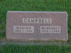
Marion F. “Tink” Campbell
| Birth | : | 9 Apr 1919 Miller, Hand County, South Dakota, USA |
| Death | : | 27 Jun 1982 Ree Heights, Hand County, South Dakota, USA |
| Burial | : | Wessington Cemetery, Hand County, USA |
| Coordinate | : | 44.4569016, -98.7102966 |
| Description | : | Marion Campbell Marion F. (Tink) Campbell, Ree Heights, died Sunday, June 27, 1982 at his home. He was born April 9, 1919 at Miller, the son of George and Laura Campbell and was raised on a farm in South Hand County. He served seven years in the Navy during World War II. He married Margaret Conerton in 1948 and she preceded him in death in 1969. He married Darlene Rowen October 3, 1971 in Wessington and they lived on a farm north of Wessington for 16 years. The past nine years... Read More |
frequently asked questions (FAQ):
-
Where is Marion F. “Tink” Campbell's memorial?
Marion F. “Tink” Campbell's memorial is located at: Wessington Cemetery, Hand County, USA.
-
When did Marion F. “Tink” Campbell death?
Marion F. “Tink” Campbell death on 27 Jun 1982 in Ree Heights, Hand County, South Dakota, USA
-
Where are the coordinates of the Marion F. “Tink” Campbell's memorial?
Latitude: 44.4569016
Longitude: -98.7102966
Family Members:
Parent

Spouse

Siblings
Flowers:


Nearby Cemetories:
1. Wessington Cemetery
Hand County, USA
Coordinate: 44.4569016, -98.7102966
2. Saint Josephs Catholic Cemetery
Hand County, USA
Coordinate: 44.4574400, -98.7100400
3. McCord Cemetery
Wessington, Beadle County, USA
Coordinate: 44.3998500, -98.6673100
4. Sand Creek Cemetery
Beadle County, USA
Coordinate: 44.3055800, -98.6791200
5. Beulah Cemetery
Vayland, Hand County, USA
Coordinate: 44.6060982, -98.8060989
6. Saint Johns Lutheran Cemetery
Wolsey, Beadle County, USA
Coordinate: 44.3927994, -98.4985962
7. Rosehill Cemetery
Hand County, USA
Coordinate: 44.2980995, -98.7731018
8. Saint Lawrence Cemetery
Saint Lawrence, Hand County, USA
Coordinate: 44.5292015, -98.9321976
9. Wolsey Cemetery
Wolsey, Beadle County, USA
Coordinate: 44.4000015, -98.4546967
10. Saint Ann's Cemetery
Miller, Hand County, USA
Coordinate: 44.5222015, -98.9732971
11. G A R Cemetery
Miller, Hand County, USA
Coordinate: 44.5078011, -98.9858017
12. Bonilla Cemetery
Bonilla, Beadle County, USA
Coordinate: 44.5830994, -98.4835968
13. Molvig Cemetery
Virgil, Beadle County, USA
Coordinate: 44.2552900, -98.6145900
14. Hillcrest Cemetery
Miller, Hand County, USA
Coordinate: 44.5207000, -99.0006100
15. Garfield Cemetery
Spink County, USA
Coordinate: 44.6622009, -98.5535965
16. Buffalo Cemetery
Spink County, USA
Coordinate: 44.6918983, -98.6853027
17. Sunbeam Cemetery
Hand County, USA
Coordinate: 44.6777992, -98.8407974
18. Burdette Cemetery
Burdette, Hand County, USA
Coordinate: 44.7002983, -98.7869034
19. Earlville Cemetery
Beadle County, USA
Coordinate: 44.2118988, -98.6091995
20. Altoona Cemetery
Hitchcock, Beadle County, USA
Coordinate: 44.6108017, -98.4113998
21. New Zion Cemetery
Hand County, USA
Coordinate: 44.2043991, -98.8206024
22. Saint Johns Cemetery
Tulare, Spink County, USA
Coordinate: 44.7202988, -98.6600037
23. Virgil Cemetery
Virgil, Beadle County, USA
Coordinate: 44.2904800, -98.4176700
24. Broadland Catholic Cemetery
Broadland, Beadle County, USA
Coordinate: 44.5005000, -98.3380800