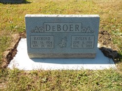
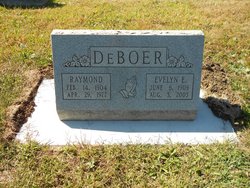
Marjorie Elaine DeBoer Schubert
| Birth | : | 22 Apr 1930 Adams, Gage County, Nebraska, USA |
| Death | : | 22 Apr 2013 Lincoln, Lancaster County, Nebraska, USA |
| Burial | : | Rosehill Cemetery, Douglas, Otoe County, USA |
| Coordinate | : | 40.5845940, -96.3867900 |
| Description | : | Marjorie Elaine Schubert, 82, Lincoln, died Monday, April 22, 2013. Born on Sept. 15, 1930 in Adams to Raymond & Evelyn (Sherman) DeBoer. Married John R. (Jack) Schubert, Aug. 4, 1950. Believer in Jesus Christ as her Lord and Savior. Member of Rosemont Alliance Church. Wife, mom, homemaker, seamstress, babysitter, bowler, roller skater, stamp collector, Sunday School secretary, etc. Survivors: husband, Jack Schubert; daughter, Carol (David) Greenhood, Rapid City, S.D.; son, Jan (Kady) Schubert, Omaha; daughter, Janet (Tom) Walker, Longmont, Colo.; daughter, Cheryl (Glenn) Hess, York; 14 grandchildren; four great grandchildren; brothers, Warren, Dwain, Ray Junior, Jim DeBoer; sisters,... Read More |
frequently asked questions (FAQ):
-
Where is Marjorie Elaine DeBoer Schubert's memorial?
Marjorie Elaine DeBoer Schubert's memorial is located at: Rosehill Cemetery, Douglas, Otoe County, USA.
-
When did Marjorie Elaine DeBoer Schubert death?
Marjorie Elaine DeBoer Schubert death on 22 Apr 2013 in Lincoln, Lancaster County, Nebraska, USA
-
Where are the coordinates of the Marjorie Elaine DeBoer Schubert's memorial?
Latitude: 40.5845940
Longitude: -96.3867900
Family Members:
Parent
Spouse
Siblings
Flowers:
Nearby Cemetories:
1. Rosehill Cemetery
Douglas, Otoe County, USA
Coordinate: 40.5845940, -96.3867900
2. Saint Martins Cemetery
Douglas, Otoe County, USA
Coordinate: 40.5844002, -96.3861008
3. Dughman Cemetery
Douglas, Otoe County, USA
Coordinate: 40.5705986, -96.3452988
4. Solon Cemetery
Otoe County, USA
Coordinate: 40.5917015, -96.4436035
5. Mount Zion Cemetery
Otoe County, USA
Coordinate: 40.6250000, -96.4449997
6. Hopewell Presbyterian Church Cemetery
Otoe County, USA
Coordinate: 40.6090150, -96.2930630
7. Hope Lutheran Cemetery
Burr, Otoe County, USA
Coordinate: 40.5525017, -96.2938995
8. Latrobe Cemetery
Sterling, Johnson County, USA
Coordinate: 40.5151000, -96.4557000
9. Pella Cemetery
Panama, Lancaster County, USA
Coordinate: 40.5555992, -96.5014038
10. Klaus Family Cemetery
Palmyra, Otoe County, USA
Coordinate: 40.6680660, -96.4398380
11. Panama Cemetery
Panama, Lancaster County, USA
Coordinate: 40.5821991, -96.5255966
12. Wilcox Cemetery
Burr, Otoe County, USA
Coordinate: 40.5254478, -96.2708740
13. Pioneer Cemetery
Palmyra, Otoe County, USA
Coordinate: 40.6903000, -96.3685989
14. Saint John North Lutheran Cemetery
Sterling, Johnson County, USA
Coordinate: 40.4689500, -96.3878500
15. Immanuel Cemetery
Sterling, Johnson County, USA
Coordinate: 40.4692001, -96.4253006
16. Saint Leos Cemetery
Palmyra, Otoe County, USA
Coordinate: 40.7111015, -96.3996964
17. Sterling Cemetery
Sterling, Johnson County, USA
Coordinate: 40.4585991, -96.3582993
18. Rosewood Cemetery
Palmyra, Otoe County, USA
Coordinate: 40.7125015, -96.3977966
19. Weber Cemetery
Sterling, Johnson County, USA
Coordinate: 40.4581000, -96.4177000
20. Helena Cemetery
Johnson County, USA
Coordinate: 40.5085983, -96.2457962
21. Unadilla Cemetery
Unadilla, Otoe County, USA
Coordinate: 40.6974983, -96.2818985
22. Bennet Cemetery
Bennet, Lancaster County, USA
Coordinate: 40.6889572, -96.5079193
23. Dudley Cemetery
Syracuse, Otoe County, USA
Coordinate: 40.6082993, -96.1988983
24. Thompson Cemetery
Otoe County, USA
Coordinate: 40.7256012, -96.3311005


