
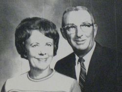

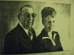
Marjorie Evelyn Ralle Leith
| Birth | : | 24 Jan 1917 Pocahontas County, Iowa, USA |
| Death | : | 25 Mar 2007 Fort Dodge, Webster County, Iowa, USA |
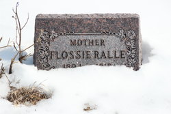
| Burial | : | Malta City Cemetery, Malta, Phillips County, USA |
| Coordinate | : | 48.3516150, -107.8667200 |
| Description | : | Marjorie E. Leith, age 90, of Pocahontas, passed away Sunday, March 25, 2007, at Trinity Regional Medical Center in Fort Dodge, Iowa. Funeral services are 10:30 a.m. Wednesday, March 28, 2007, at the Hope United Methodist Church in Pocahontas with the Rev. Thorne Wittstruck officiating. Burial is in Washington Cemetery near Havelock, Iowa. Visitation is 4 to 7 p.m. today, March 27 at the Powers Funeral Home in Pocahontas. Survivors include her daughters, Janet Ann (Richard) Block of Rockwell City and Beverly Jean (Donald) Hopkins of Pocahontas. |
frequently asked questions (FAQ):
-
Where is Marjorie Evelyn Ralle Leith's memorial?
Marjorie Evelyn Ralle Leith's memorial is located at: Malta City Cemetery, Malta, Phillips County, USA.
-
When did Marjorie Evelyn Ralle Leith death?
Marjorie Evelyn Ralle Leith death on 25 Mar 2007 in Fort Dodge, Webster County, Iowa, USA
-
Where are the coordinates of the Marjorie Evelyn Ralle Leith's memorial?
Latitude: 48.3516150
Longitude: -107.8667200
Family Members:
Flowers:


Nearby Cemetories:
1. Malta City Cemetery
Malta, Phillips County, USA
Coordinate: 48.3516150, -107.8667200
2. East Malta Hutterite Colony Cemetery
East Malta Colony, Phillips County, USA
Coordinate: 48.3473997, -107.6095182
3. Scandia Lutheran Cemetery
Malta, Phillips County, USA
Coordinate: 48.1885210, -107.7866940
4. Bowdoin Cemetery
Bowdoin, Phillips County, USA
Coordinate: 48.3786000, -107.5903000
5. Hillside Cemetery
Dodson, Phillips County, USA
Coordinate: 48.4122009, -108.2352982
6. Graveyard Hill Cemetery
Phillips County, USA
Coordinate: 48.3847008, -108.3638992
7. Grandview Cemetery
Saco, Phillips County, USA
Coordinate: 48.4938930, -107.3460170
8. Loring Colony Cemetery
Loring, Phillips County, USA
Coordinate: 48.7879148, -107.9747077
9. Forks Cemetery
Whitewater, Phillips County, USA
Coordinate: 48.7206500, -107.4905000
10. Fort Belknap Cemetery
Harlem, Blaine County, USA
Coordinate: 48.4347210, -108.5595860
11. Midale Cemetery
Phillips County, USA
Coordinate: 47.9096985, -108.1063995
12. Messerly Cemetery
Blaine County, USA
Coordinate: 48.0630989, -108.4385986
13. Kirkaldie Cemetery
Blaine County, USA
Coordinate: 48.0266991, -108.4505997
14. Hillview Cemetery
Hinsdale, Valley County, USA
Coordinate: 48.3828011, -107.0847015
15. Reitan Cemetery
Saco, Phillips County, USA
Coordinate: 48.7567400, -107.3593400
16. Big Warm Cemetery
Blaine County, USA
Coordinate: 48.0071983, -108.4655991
17. Chopwoid Cemetery
Blaine County, USA
Coordinate: 48.0071983, -108.4772034
18. Sacred Heart Catholic Cemetery
Fort Belknap Agency, Blaine County, USA
Coordinate: 48.4489000, -108.6582000
19. Lodge Pole Cemetery
Lodge Pole, Blaine County, USA
Coordinate: 48.0371430, -108.5260870
20. Turner Colony Cemetery
Turner Colony, Blaine County, USA
Coordinate: 48.7595000, -108.4369000
21. Jordan Coulee Cemetery
Valley County, USA
Coordinate: 48.7075900, -107.1230100
22. Agency Cemetery
Fort Belknap Agency, Blaine County, USA
Coordinate: 48.4767000, -108.7702000
23. Zortman Cemetery
Phillips County, USA
Coordinate: 47.9185710, -108.5166620
24. Turner Cemetery
Turner, Blaine County, USA
Coordinate: 48.8610001, -108.4120026