
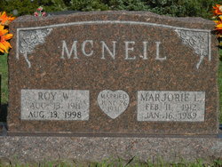
Marjorie Luella Phillips McNeil
| Birth | : | 11 Feb 1912 Beadle County, South Dakota, USA |
| Death | : | 16 Jan 1989 Huron, Beadle County, South Dakota, USA |
| Burial | : | Wessington Cemetery, Hand County, USA |
| Coordinate | : | 44.4569016, -98.7102966 |
| Description | : | Mrs. Roy McNeil Mrs. Roy (Marjorie) McNeil, 76, Wessington, died Monday, Jan. 16, 1989 at Huron Regional Medical Center. The funeral was 2 p.m. Thursday at the Wessington Presbyterian Church, with the Rev. Stan Gruneich officiating. Burial was in the Wessington Cemetery. Marjorie Luella Phillips was born February 11, 1912 to George and Blanche (Marshall) Phillips, in Whiteside Township, Beadle County. In 1931 she graduated from Wessington High School. On June 26, 1931, she married Roy McNeil in Huron. They made their home on a farm south of Wessington until 1986 when they moved into Wessington. She was a member of the... Read More |
frequently asked questions (FAQ):
-
Where is Marjorie Luella Phillips McNeil's memorial?
Marjorie Luella Phillips McNeil's memorial is located at: Wessington Cemetery, Hand County, USA.
-
When did Marjorie Luella Phillips McNeil death?
Marjorie Luella Phillips McNeil death on 16 Jan 1989 in Huron, Beadle County, South Dakota, USA
-
Where are the coordinates of the Marjorie Luella Phillips McNeil's memorial?
Latitude: 44.4569016
Longitude: -98.7102966
Family Members:
Parent

Spouse

Siblings
Children

Flowers:


Nearby Cemetories:
1. Wessington Cemetery
Hand County, USA
Coordinate: 44.4569016, -98.7102966
2. Saint Josephs Catholic Cemetery
Hand County, USA
Coordinate: 44.4574400, -98.7100400
3. McCord Cemetery
Wessington, Beadle County, USA
Coordinate: 44.3998500, -98.6673100
4. Sand Creek Cemetery
Beadle County, USA
Coordinate: 44.3055800, -98.6791200
5. Beulah Cemetery
Vayland, Hand County, USA
Coordinate: 44.6060982, -98.8060989
6. Saint Johns Lutheran Cemetery
Wolsey, Beadle County, USA
Coordinate: 44.3927994, -98.4985962
7. Rosehill Cemetery
Hand County, USA
Coordinate: 44.2980995, -98.7731018
8. Saint Lawrence Cemetery
Saint Lawrence, Hand County, USA
Coordinate: 44.5292015, -98.9321976
9. Wolsey Cemetery
Wolsey, Beadle County, USA
Coordinate: 44.4000015, -98.4546967
10. Saint Ann's Cemetery
Miller, Hand County, USA
Coordinate: 44.5222015, -98.9732971
11. G A R Cemetery
Miller, Hand County, USA
Coordinate: 44.5078011, -98.9858017
12. Bonilla Cemetery
Bonilla, Beadle County, USA
Coordinate: 44.5830994, -98.4835968
13. Molvig Cemetery
Virgil, Beadle County, USA
Coordinate: 44.2552900, -98.6145900
14. Hillcrest Cemetery
Miller, Hand County, USA
Coordinate: 44.5207000, -99.0006100
15. Garfield Cemetery
Spink County, USA
Coordinate: 44.6622009, -98.5535965
16. Buffalo Cemetery
Spink County, USA
Coordinate: 44.6918983, -98.6853027
17. Sunbeam Cemetery
Hand County, USA
Coordinate: 44.6777992, -98.8407974
18. Burdette Cemetery
Burdette, Hand County, USA
Coordinate: 44.7002983, -98.7869034
19. Earlville Cemetery
Beadle County, USA
Coordinate: 44.2118988, -98.6091995
20. Altoona Cemetery
Hitchcock, Beadle County, USA
Coordinate: 44.6108017, -98.4113998
21. New Zion Cemetery
Hand County, USA
Coordinate: 44.2043991, -98.8206024
22. Saint Johns Cemetery
Tulare, Spink County, USA
Coordinate: 44.7202988, -98.6600037
23. Virgil Cemetery
Virgil, Beadle County, USA
Coordinate: 44.2904800, -98.4176700
24. Broadland Catholic Cemetery
Broadland, Beadle County, USA
Coordinate: 44.5005000, -98.3380800