

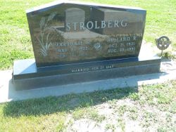
Marjorie R “Marj” Sall Strolberg
| Birth | : | 31 May 1922 Phelps County, Nebraska, USA |
| Death | : | 25 Feb 2016 Minden, Kearney County, Nebraska, USA |
| Burial | : | Bethany Cemetery, Axtell, Kearney County, USA |
| Coordinate | : | 40.4665413, -99.0843201 |
| Plot | : | Block 5 Lot 29 |
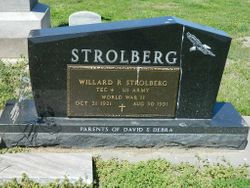
| Description | : | Marjorie was born on May 31, 1922, in Phelps County to Peter M and Lillie (Lundberg) Sall. She grew up in that area, graduated from Holdrege High School and then went to business college. Marjorie worked at the ASCS office in Holdrege for a short time. On February 27, 1943, she married Willard Strolberg in Kentucky while Willard served in the military. Willard went overseas, and Marjorie moved back to Nebraska until Willard came home. In 1947, they moved to a farm near Axtell and in 1961, they moved to the Strolberg farmstead. Willard died in 1991. Marjorie was... Read More |
frequently asked questions (FAQ):
-
Where is Marjorie R “Marj” Sall Strolberg's memorial?
Marjorie R “Marj” Sall Strolberg's memorial is located at: Bethany Cemetery, Axtell, Kearney County, USA.
-
When did Marjorie R “Marj” Sall Strolberg death?
Marjorie R “Marj” Sall Strolberg death on 25 Feb 2016 in Minden, Kearney County, Nebraska, USA
-
Where are the coordinates of the Marjorie R “Marj” Sall Strolberg's memorial?
Latitude: 40.4665413
Longitude: -99.0843201
Family Members:
Parent

Spouse
Siblings
Flowers:


Nearby Cemetories:
1. Bethany Cemetery
Axtell, Kearney County, USA
Coordinate: 40.4665413, -99.0843201
2. Bethphage Cemetery
Axtell, Kearney County, USA
Coordinate: 40.4882750, -99.1190130
3. Pleasant Hill Cemetery
Axtell, Kearney County, USA
Coordinate: 40.4870000, -99.1235000
4. Keene Family Cemetery
Keene, Kearney County, USA
Coordinate: 40.4270500, -99.0658900
5. Keene Cemetery
Keene, Kearney County, USA
Coordinate: 40.4227700, -99.0747900
6. Salem Methodist Church Cemetery
Axtell, Kearney County, USA
Coordinate: 40.4528000, -99.1790000
7. Minden Cemetery
Minden, Kearney County, USA
Coordinate: 40.4950400, -98.9619900
8. Garden Plain Cemetery
Minden, Kearney County, USA
Coordinate: 40.3792000, -99.0186005
9. Fridhem Cemetery
Funk, Phelps County, USA
Coordinate: 40.4678001, -99.2174988
10. Wilcox Cemetery
Wilcox, Kearney County, USA
Coordinate: 40.3657990, -99.1511002
11. Fredericksburg Cemetery
Minden, Kearney County, USA
Coordinate: 40.4261560, -98.9319700
12. Mound Valley Cemetery
Blaine Township, Kearney County, USA
Coordinate: 40.5849341, -99.1428820
13. White Hill Cemetery
Kearney County, USA
Coordinate: 40.5675011, -98.9805984
14. Saint Peters Cemetery
Hildreth, Franklin County, USA
Coordinate: 40.3280983, -99.0475006
15. Hildreth Cemetery
Hildreth, Franklin County, USA
Coordinate: 40.3293991, -99.0294037
16. Free Mission Cemetery
Kearney County, USA
Coordinate: 40.4030991, -98.9139023
17. Saint Johns Cemetery
Franklin County, USA
Coordinate: 40.3222008, -99.1631012
18. Bethel Cemetery
Phelps County, USA
Coordinate: 40.4463997, -99.3031006
19. Magill Cemetery
Phelps County, USA
Coordinate: 40.5539017, -99.2850037
20. Liberty Cemetery
Minden, Kearney County, USA
Coordinate: 40.5833015, -98.9041977
21. Freewater Cemetery
Ragan, Harlan County, USA
Coordinate: 40.3083000, -99.2071991
22. Antelope Cemetery
Ragan, Harlan County, USA
Coordinate: 40.3356018, -99.2557983
23. Fort Kearney Post Cemetery
Buffalo County, USA
Coordinate: 40.6429000, -99.0066400
24. Emmanuel Lutheran Cemetery
Hildreth, Franklin County, USA
Coordinate: 40.2782000, -99.0284000