
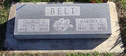

Martha Corrine McDaniel Belt
| Birth | : | 18 Dec 1942 Reece, Greenwood County, Kansas, USA |
| Death | : | 26 Sep 2016 Council Grove, Morris County, Kansas, USA |
| Burial | : | Comiskey Cemetery, Morris County, USA |
| Coordinate | : | 38.6521988, -96.3535995 |
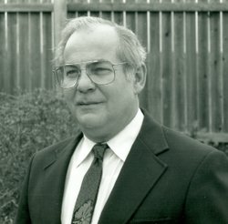
| Description | : | Martha Corrine Belt, 73, of Council Grove, Kansas passed away September 26, 2016, at Diversicare of Council Grove. She was born December 18, 1942, in Reece, KS, the daughter of Dennis and Erma (Peebles) McDaniel. She married George Belt on November 7, 1959. Martha was a member of the Council Grove Community Church. Along with her husband George, she was the owner of “George’s Drive In Market”, “G & M Auto Parts Store” in Strong City and “MarCor Sales”, a parts and tools wholesale distributor. Martha worked as a bookkeeper for “S & S Oil Company” in Emporia and later,... Read More |
frequently asked questions (FAQ):
-
Where is Martha Corrine McDaniel Belt's memorial?
Martha Corrine McDaniel Belt's memorial is located at: Comiskey Cemetery, Morris County, USA.
-
When did Martha Corrine McDaniel Belt death?
Martha Corrine McDaniel Belt death on 26 Sep 2016 in Council Grove, Morris County, Kansas, USA
-
Where are the coordinates of the Martha Corrine McDaniel Belt's memorial?
Latitude: 38.6521988
Longitude: -96.3535995
Family Members:
Parent

Spouse
Siblings
Children
Flowers:


Nearby Cemetories:
1. Comiskey Cemetery
Morris County, USA
Coordinate: 38.6521988, -96.3535995
2. Raglan Cemetery
Dunlap, Morris County, USA
Coordinate: 38.6370100, -96.3942700
3. Gilbert Family Cemetery
Bushong, Lyon County, USA
Coordinate: 38.6895800, -96.3458500
4. Little John Cemetery
Council Grove, Morris County, USA
Coordinate: 38.6568300, -96.4175100
5. Dunlap Colored Cemetery
Dunlap, Morris County, USA
Coordinate: 38.5875015, -96.3538971
6. Agnes City Cemetery
Bushong, Lyon County, USA
Coordinate: 38.6880989, -96.2799988
7. Sunnyside Cemetery
Bushong, Lyon County, USA
Coordinate: 38.6083900, -96.2853700
8. Dunlap Cemetery
Dunlap, Morris County, USA
Coordinate: 38.5792007, -96.3538971
9. Henry Clousing Burial Site
Bushong, Lyon County, USA
Coordinate: 38.6954800, -96.2608700
10. Hebrank Cemetery
Council Grove, Morris County, USA
Coordinate: 38.7172000, -96.4260100
11. Bushong Cemetery
Bushong, Lyon County, USA
Coordinate: 38.6366997, -96.2431030
12. Sunnyslope Memorial Gardens
Council Grove, Morris County, USA
Coordinate: 38.6796700, -96.4644400
13. Greenwood Cemetery
Council Grove, Morris County, USA
Coordinate: 38.6581900, -96.5010900
14. Exon Family Cemetery
Eskridge, Wabaunsee County, USA
Coordinate: 38.7595800, -96.2988400
15. Calvary Cemetery
Council Grove, Morris County, USA
Coordinate: 38.6567001, -96.5111008
16. Chalk Cemetery
Wabaunsee County, USA
Coordinate: 38.7675018, -96.2910995
17. Four Mile Cemetery
Council Grove, Morris County, USA
Coordinate: 38.6086200, -96.5097000
18. Pleasant Ridge Cemetery
Wabaunsee County, USA
Coordinate: 38.7969017, -96.3347015
19. Fruitland Cemetery
Americus, Lyon County, USA
Coordinate: 38.5078011, -96.3308029
20. Allen Cemetery
Allen, Lyon County, USA
Coordinate: 38.6521988, -96.1611023
21. Frost Cemetery
Americus, Lyon County, USA
Coordinate: 38.5573900, -96.2022300
22. Garfield Cemetery
Morris County, USA
Coordinate: 38.7817001, -96.4591980
23. Prairie View Cemetery
Wabaunsee County, USA
Coordinate: 38.8114014, -96.3696976
24. Americus Cemetery
Americus, Lyon County, USA
Coordinate: 38.5154686, -96.2420425