
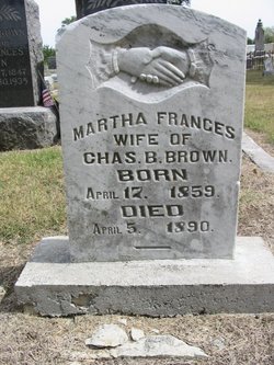

Martha Frances Gardner Brown
| Birth | : | 17 Apr 1859 |
| Death | : | 5 Apr 1890 Chanute, Neosho County, Kansas, USA |
| Burial | : | Salem Baptist Church Cemetery, Dobson, Surry County, USA |
| Coordinate | : | 36.3738060, -80.7040024 |
| Description | : | Wife of Charles B. Brown CHANUTE BLADE, APRIL 11, 1890 DIED--In this city at 2 pm Saturday, April 5, of consumption, Mrs. Brown, aged 31 years. Mrs. Brown had been a sufferer for some time past, the last 6 months of which she was confined to her bed. She bore her suffering with that fortitude which none but the christian possesses. She leaves a husband and small child and a large circle of friends to mourn her loss. Note: bio info provided by Contributor: Gypsy Girl (47851655) |
frequently asked questions (FAQ):
-
Where is Martha Frances Gardner Brown's memorial?
Martha Frances Gardner Brown's memorial is located at: Salem Baptist Church Cemetery, Dobson, Surry County, USA.
-
When did Martha Frances Gardner Brown death?
Martha Frances Gardner Brown death on 5 Apr 1890 in Chanute, Neosho County, Kansas, USA
-
Where are the coordinates of the Martha Frances Gardner Brown's memorial?
Latitude: 36.3738060
Longitude: -80.7040024
Family Members:
Parent
Spouse
Siblings
Children

Flowers:


Nearby Cemetories:
1. Salem Baptist Church Cemetery
Dobson, Surry County, USA
Coordinate: 36.3738060, -80.7040024
2. Snow Family Cemetery
Dobson, Surry County, USA
Coordinate: 36.3659170, -80.7149720
3. Kidd Family Cemetery
Dobson, Surry County, USA
Coordinate: 36.3844530, -80.6805900
4. Collins Family Cemetery
Dobson, Surry County, USA
Coordinate: 36.3971190, -80.7027550
5. Dobson Church of God
Dobson, Surry County, USA
Coordinate: 36.3975040, -80.7043410
6. Church of God Cemetery
Dobson, Surry County, USA
Coordinate: 36.3982460, -80.7046440
7. Stanley Cemetery
Dobson, Surry County, USA
Coordinate: 36.3497420, -80.6878850
8. Cave Cemetery
Dobson, Surry County, USA
Coordinate: 36.3784110, -80.7380100
9. Dobson Town Cemetery
Dobson, Surry County, USA
Coordinate: 36.3983345, -80.7249451
10. Turkey Ford Baptist Church Cemetery
Turkey Ford, Surry County, USA
Coordinate: 36.3866360, -80.6636720
11. James Martin Venable Family Cemetery
Surry County, USA
Coordinate: 36.3458611, -80.6760000
12. Fairview Church of Christ Cemetery
Dobson, Surry County, USA
Coordinate: 36.3463060, -80.7332780
13. Fisher River Primitive Baptist Church Cemetery
Dobson, Surry County, USA
Coordinate: 36.4112220, -80.7046110
14. New Home Church of Christ Cemetery
Dobson, Surry County, USA
Coordinate: 36.3625800, -80.6583480
15. Badgett Family Cemetery
Mount Airy, Surry County, USA
Coordinate: 36.4122500, -80.7061670
16. Welcome View Baptist Church Cemetery
Union Cross, Surry County, USA
Coordinate: 36.3607216, -80.7496643
17. Little Vine Primitive Baptist Cemetery
Dobson, Surry County, USA
Coordinate: 36.3961372, -80.7490540
18. County Home Cemetery
New Hope, Surry County, USA
Coordinate: 36.4192840, -80.7152490
19. Piney Grove Baptist Church Cemetery
White Plains, Surry County, USA
Coordinate: 36.4138080, -80.6742100
20. Fairview Baptist Church Cemetery
Fairview, Surry County, USA
Coordinate: 36.3277855, -80.7181091
21. Liberty Baptist Church Cemetery
Dobson, Surry County, USA
Coordinate: 36.3330345, -80.6722488
22. Copeland Home Graveyard
Dobson, Surry County, USA
Coordinate: 36.4223490, -80.7089350
23. Marion Family Cemetery
Dobson, Surry County, USA
Coordinate: 36.4101530, -80.6633480
24. Second Chance Church Cemetery
Fairview, Surry County, USA
Coordinate: 36.3248560, -80.7030870