
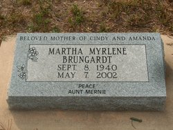

Martha Myrlene Castor Brungardt
| Birth | : | 8 Sep 1940 Okmulgee, Okmulgee County, Oklahoma, USA |
| Death | : | 7 May 2002 Hutchinson, Barton County, Kansas, USA |
| Burial | : | Natoma Cemetery, Natoma, Osborne County, USA |
| Coordinate | : | 39.1907700, -99.0162700 |
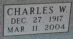
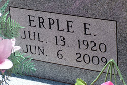
| Description | : | Memorial services for M. Myrlene Brungardt, 61, Great Bend, will be at 10:30 a.m. Friday at Great Bend Family Mortuary. Inurnment will be in Great Bend Cemetery. Mrs. Brungardt died Tuesday, May 7, 2002, at Hutchinson Hospital. She was born Sept. 8, 1940, in Okmulgee, Okla., the daughter of Charles W. and Erple E. (Weaver) Castor. She had lived in Great Bend for three years, moving from Russell. She worked in food service in the Great Bend school district. She was also a 4-H leader and board member in Ellis County and a member of Rainbow Girls, Natoma. She... Read More |
frequently asked questions (FAQ):
-
Where is Martha Myrlene Castor Brungardt's memorial?
Martha Myrlene Castor Brungardt's memorial is located at: Natoma Cemetery, Natoma, Osborne County, USA.
-
When did Martha Myrlene Castor Brungardt death?
Martha Myrlene Castor Brungardt death on 7 May 2002 in Hutchinson, Barton County, Kansas, USA
-
Where are the coordinates of the Martha Myrlene Castor Brungardt's memorial?
Latitude: 39.1907700
Longitude: -99.0162700
Family Members:
Parent
Spouse

Siblings
Flowers:


Nearby Cemetories:
1. Natoma Cemetery
Natoma, Osborne County, USA
Coordinate: 39.1907700, -99.0162700
2. Natoma Lutheran Cemetery
Natoma, Osborne County, USA
Coordinate: 39.1907700, -99.0162700
3. Natoma Catholic Cemetery
Natoma, Osborne County, USA
Coordinate: 39.2054050, -99.0289480
4. Immanuel Lutheran Cemetery
Natoma, Osborne County, USA
Coordinate: 39.2708015, -99.0096970
5. Mount Hermon Cemetery
Paradise, Russell County, USA
Coordinate: 39.1324997, -98.9439011
6. Bowlby Ranch Cemetery
Ellis County, USA
Coordinate: 39.1127430, -99.0513540
7. Round Mound Cemetery
Osborne County, USA
Coordinate: 39.2630997, -98.9636002
8. Conger Cemetery
Plainville, Rooks County, USA
Coordinate: 39.1978700, -99.1232100
9. IXL Cemetery
Natoma, Osborne County, USA
Coordinate: 39.2491989, -98.9218979
10. Aurora Cemetery
Laton, Rooks County, USA
Coordinate: 39.2778015, -99.0847015
11. Shiloh Cemetery
Codell, Rooks County, USA
Coordinate: 39.2350006, -99.1410980
12. Victor Cemetery
Osborne County, USA
Coordinate: 39.2380981, -98.8613968
13. Norman Cemetery
Ellis County, USA
Coordinate: 39.1044006, -99.1575012
14. Chalk Mound Cemetery
Laton, Rooks County, USA
Coordinate: 39.3208008, -99.0852966
15. Fairport Cemetery
Russell County, USA
Coordinate: 39.0463982, -99.0207977
16. Cedar Bluff Cemetery
Osborne County, USA
Coordinate: 39.2496986, -98.8431015
17. Pleasant Plain Cemetery
Osborne County, USA
Coordinate: 39.3367004, -99.0372009
18. Paradise Center Cemetery
Codell, Rooks County, USA
Coordinate: 39.2050570, -99.2058100
19. Cole Cemetery
Osborne County, USA
Coordinate: 39.2352982, -98.8060989
20. Waldo Catholic Cemetery
Waldo Township, Russell County, USA
Coordinate: 39.1036600, -98.8162400
21. Covert Cemetery
Osborne County, USA
Coordinate: 39.2896996, -98.8107986
22. Mount Ayr Cemetery
Alton, Osborne County, USA
Coordinate: 39.3764000, -98.9717026
23. Twin Mound Cemetery
Rooks County, USA
Coordinate: 39.2855988, -99.2319031
24. Survey Cemetery
Woodston, Rooks County, USA
Coordinate: 39.3722000, -99.1333008