

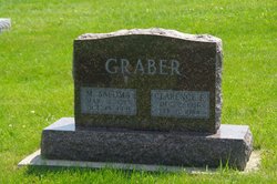
Martha Soloma “Sally” Bare Graber
| Birth | : | 6 Mar 1913 Kansas, USA |
| Death | : | 19 Oct 1991 Wayland, Henry County, Iowa, USA |
| Burial | : | Sugar Creek Cemetery, Wayland, Henry County, USA |
| Coordinate | : | 41.1347008, -91.6343994 |
| Description | : | Burlington (IA) Hawkeye Sunday, 20 October 1991 Soloma 'Sally' Graber Mrs. Soloma "Sally" Graber, 78, Route 4, Mount Pleasant, died at 5:35 a.m. Saturday, Oct. 19, 1991, at Parkview Home, Wayland. Born March 6, 1913 at Harper, Kan., she was the daughter of Mahlon and Anna Holdeman Bare. She was married Oct. 4, 1940, at Wayland to Clarence Elmer Graber, who died Feb. 5, 1984. She was a member of Pleasant View Mennonite Church, Mount Pleasant, and was known statewide in the women's organizations of the Mennonite Church. She and her husband raised many foster sons in their home for many years. Surviving are three sons,... Read More |
frequently asked questions (FAQ):
-
Where is Martha Soloma “Sally” Bare Graber's memorial?
Martha Soloma “Sally” Bare Graber's memorial is located at: Sugar Creek Cemetery, Wayland, Henry County, USA.
-
When did Martha Soloma “Sally” Bare Graber death?
Martha Soloma “Sally” Bare Graber death on 19 Oct 1991 in Wayland, Henry County, Iowa, USA
-
Where are the coordinates of the Martha Soloma “Sally” Bare Graber's memorial?
Latitude: 41.1347008
Longitude: -91.6343994
Family Members:
Parent
Spouse
Siblings
Flowers:


Nearby Cemetories:
1. Sugar Creek Cemetery
Wayland, Henry County, USA
Coordinate: 41.1347008, -91.6343994
2. Wayland Methodist Church Cemetery
Wayland, Henry County, USA
Coordinate: 41.1480000, -91.6585000
3. Old Baptist Cemetery
Wayland, Henry County, USA
Coordinate: 41.1045000, -91.6209000
4. Center Cemetery
Wayland, Henry County, USA
Coordinate: 41.1567000, -91.6013000
5. North Hill Cemetery
Washington County, USA
Coordinate: 41.1666985, -91.6592026
6. Eicher Cemetery
Washington County, USA
Coordinate: 41.1782990, -91.6260986
7. Finley Cemetery
Henry County, USA
Coordinate: 41.0913800, -91.6202800
8. Pioneer Shively-Neff Cemetery
Wayland, Henry County, USA
Coordinate: 41.1420950, -91.7027100
9. Rumble Cemetery
Washington County, USA
Coordinate: 41.1857500, -91.6150500
10. Cottonwood Cemetery
Coppock, Henry County, USA
Coordinate: 41.1488991, -91.7024994
11. Haynes Cemetery
Wayland, Henry County, USA
Coordinate: 41.1441000, -91.7074000
12. Kurtz Cemetery
Wayland, Henry County, USA
Coordinate: 41.1470000, -91.7071000
13. Sommers Cemetery
Washington County, USA
Coordinate: 41.1927986, -91.6505966
14. Fern Cliff Evangelic Cemetery
Washington County, USA
Coordinate: 41.1937000, -91.6122000
15. Nelson Plot
Jefferson County, USA
Coordinate: 41.1243890, -91.7185420
16. Bethel Mennonite Church Cemetery
Washington County, USA
Coordinate: 41.1963997, -91.6596985
17. Green Mound Cemetery
Henry County, USA
Coordinate: 41.0696983, -91.6652985
18. Martin Cemetery
Marion Township, Washington County, USA
Coordinate: 41.2000194, -91.6668323
19. North Wayne Cemetery
Olds, Henry County, USA
Coordinate: 41.1422000, -91.5422000
20. Swedesburg Cemetery
Swedesburg, Henry County, USA
Coordinate: 41.1060000, -91.5456000
21. Custer Cemetery
Washington County, USA
Coordinate: 41.1921500, -91.7125900
22. Asbury Cemetery
Olds, Henry County, USA
Coordinate: 41.1570000, -91.5253000
23. Armstrong Cemetery
Jefferson County, USA
Coordinate: 41.1547012, -91.7444000
24. Dallner Cemetery
Jefferson County, USA
Coordinate: 41.1047000, -91.7458000