
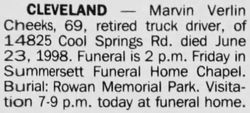
Marvin Verlin Cheeks
| Birth | : | 26 Nov 1928 Surry County, North Carolina, USA |
| Death | : | 1998 Charlotte, Mecklenburg County, North Carolina, USA |
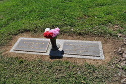
| Burial | : | Rowan Memorial Park Cemetery, Salisbury, Rowan County, USA |
| Coordinate | : | 35.7178001, -80.4955978 |
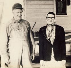
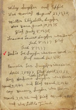
| Description | : | Son of Lonnie M. Cheek & Effie Mae Brooks 09 Nov 1924 Surry Co, NC One of three children; 1 sister & 1 brother ****************************** 1926 Willie Lee***see below 1931 Della Mae (Gunter) # 92627515 Note*** His mother later married; Wiley Henderson Snyder 30 Aug 1934 • Rowan Co, NC Six half-siblings; 3 half-sisters & 3 half-brothers ****************************** 1935 Mirttis Elizabeth d. 1935 1937 Frances Louise d. 1937 1938 Unnamed Boy***see below 1939 Bonnie Lee***see below 1941 Coy Henderson***see below 1941 Roy Andrew***see below |
frequently asked questions (FAQ):
-
Where is Marvin Verlin Cheeks's memorial?
Marvin Verlin Cheeks's memorial is located at: Rowan Memorial Park Cemetery, Salisbury, Rowan County, USA.
-
When did Marvin Verlin Cheeks death?
Marvin Verlin Cheeks death on 1998 in Charlotte, Mecklenburg County, North Carolina, USA
-
Where are the coordinates of the Marvin Verlin Cheeks's memorial?
Latitude: 35.7178001
Longitude: -80.4955978
Family Members:
Parent

Siblings
Flowers:


Nearby Cemetories:
1. Rowan Memorial Park Cemetery
Salisbury, Rowan County, USA
Coordinate: 35.7178001, -80.4955978
2. Bethel Lutheran Church Cemetery
Franklin, Rowan County, USA
Coordinate: 35.7212500, -80.4909410
3. Franklin Presbyterian Church Cemetery
Franklin, Rowan County, USA
Coordinate: 35.7246880, -80.5032580
4. Sacred Heart Roman Catholic Cemetery
Salisbury, Rowan County, USA
Coordinate: 35.7077500, -80.5074440
5. Old Lebanon Methodist Church Cemetery
Salisbury, Rowan County, USA
Coordinate: 35.7248800, -80.4752750
6. Gloria Dei Lutheran Church Columbarium
Salisbury, Rowan County, USA
Coordinate: 35.6938358, -80.5110054
7. Enon Baptist Church Cemetery
Salisbury, Rowan County, USA
Coordinate: 35.7082291, -80.5275421
8. Ardis Chapel AME Zion Church Cemetery
Salisbury, Rowan County, USA
Coordinate: 35.7038918, -80.4660721
9. Calvary Baptist Church Cemetery
Salisbury, Rowan County, USA
Coordinate: 35.7240510, -80.4600340
10. Mount Tabor United Methodist Church Cemetery
Salisbury, Rowan County, USA
Coordinate: 35.7406520, -80.4718440
11. Salisbury National Cemetery Annex
Salisbury, Rowan County, USA
Coordinate: 35.6879710, -80.4912790
12. Second Creek AME Zion - New Birth of Christ Church
Franklin Township, Rowan County, USA
Coordinate: 35.7461100, -80.5252800
13. Oakwood Cemetery
Salisbury, Rowan County, USA
Coordinate: 35.6789040, -80.4985750
14. Memorial Park Cemetery
Salisbury, Rowan County, USA
Coordinate: 35.6784680, -80.4800140
15. Oakdale Union Hill Cemetery
Salisbury, Rowan County, USA
Coordinate: 35.6763130, -80.4905630
16. Second Creek AME Zion Cemetery
Franklin, Rowan County, USA
Coordinate: 35.7572189, -80.5209352
17. Owens Cemetery
Franklin, Rowan County, USA
Coordinate: 35.7581730, -80.5205010
18. The Arbor United Methodist Church Cemetery
Salisbury, Rowan County, USA
Coordinate: 35.7356700, -80.5509200
19. Saint Matthew's Episcopal Church Cemetery
Salisbury, Rowan County, USA
Coordinate: 35.7058983, -80.5554962
20. First Baptist Church of Salisbury Columbarium
Salisbury, Rowan County, USA
Coordinate: 35.6710000, -80.4710400
21. Old English Cemetery
Salisbury, Rowan County, USA
Coordinate: 35.6699982, -80.4697037
22. Presbyterian Session House Burial Ground
Salisbury, Rowan County, USA
Coordinate: 35.6690550, -80.4720260
23. Oak Grove Freedman's Cemetery
Salisbury, Rowan County, USA
Coordinate: 35.6697700, -80.4693000
24. Saint John's Lutheran Columbarium and Garden
Salisbury, Rowan County, USA
Coordinate: 35.6688340, -80.4715850