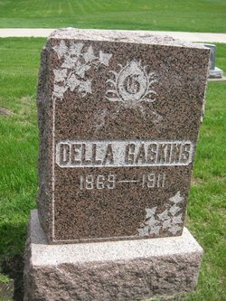
Mary Adell “Della” King Gaskins
| Birth | : | 1869 Black Hawk County, Iowa, USA |
| Death | : | 21 Nov 1911 Waterloo, Black Hawk County, Iowa, USA |
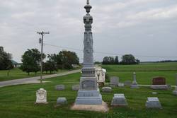
| Burial | : | Grove Road Cemetery, Harrogate, Harrogate Borough, England |
| Coordinate | : | 53.9996400, -1.5356000 |
| Plot | : | Block 5 Lot 42 |
frequently asked questions (FAQ):
-
Where is Mary Adell “Della” King Gaskins's memorial?
Mary Adell “Della” King Gaskins's memorial is located at: Grove Road Cemetery, Harrogate, Harrogate Borough, England.
-
When did Mary Adell “Della” King Gaskins death?
Mary Adell “Della” King Gaskins death on 21 Nov 1911 in Waterloo, Black Hawk County, Iowa, USA
-
Where are the coordinates of the Mary Adell “Della” King Gaskins's memorial?
Latitude: 53.9996400
Longitude: -1.5356000
Family Members:
Parent
Siblings
Children
Flowers:
Nearby Cemetories:
1. Grove Road Cemetery
Harrogate, Harrogate Borough, England
Coordinate: 53.9996400, -1.5356000
2. St Peter Church War Memorial
Harrogate, Harrogate Borough, England
Coordinate: 53.9931340, -1.5412160
3. Harrogate War Memorial
Harrogate, Harrogate Borough, England
Coordinate: 53.9926370, -1.5419270
4. Christ Churchyard
Harrogate, Harrogate Borough, England
Coordinate: 53.9938540, -1.5261070
5. St John the Evangelist Churchyard
Bilton, Harrogate Borough, England
Coordinate: 54.0080790, -1.5373560
6. Harlow Hill Cemetery
Harrogate, Harrogate Borough, England
Coordinate: 53.9803290, -1.5646610
7. Stonefall Cemetery and Crematorium
Harrogate, Harrogate Borough, England
Coordinate: 53.9854830, -1.4953260
8. St Thomas the Apostle Churchyard
Killinghall, Harrogate Borough, England
Coordinate: 54.0206880, -1.5669210
9. St Thomas Churchyard
Scotton, Harrogate Borough, England
Coordinate: 54.0296020, -1.5037280
10. Mother Shiptons Cave
Knaresborough, Harrogate Borough, England
Coordinate: 54.0086910, -1.4747050
11. Friends Burial Ground
Scotton, Harrogate Borough, England
Coordinate: 54.0312900, -1.5029300
12. St John the Baptist Churchyard
Knaresborough, Harrogate Borough, England
Coordinate: 54.0097850, -1.4718200
13. St. Robert of Knaresborough Churchyard
Pannal, Harrogate Borough, England
Coordinate: 53.9604110, -1.5344860
14. Holy Trinity Churchyard
Knaresborough, Harrogate Borough, England
Coordinate: 54.0057800, -1.4659670
15. St Paul and St Margaret Churchyard
Nidd, Harrogate Borough, England
Coordinate: 54.0423920, -1.5417480
16. All Saints Churchyard
Ripley, Harrogate Borough, England
Coordinate: 54.0397200, -1.5687800
17. St Joseph and St James Churchyard
Follifoot, Harrogate Borough, England
Coordinate: 53.9690940, -1.4788570
18. Knaresborough Cemetery
Knaresborough, Harrogate Borough, England
Coordinate: 54.0051260, -1.4585390
19. St John the Baptist Churchyard
Brearton, Harrogate Borough, England
Coordinate: 54.0442190, -1.5074460
20. St Thomas Becket Churchyard
Hampsthwaite, Harrogate Borough, England
Coordinate: 54.0267170, -1.6054560
21. St Oswald Churchyard
Farnham, Harrogate Borough, England
Coordinate: 54.0398420, -1.4698910
22. Kirkby Overblow Cemetery
Kirkby Overblow, Harrogate Borough, England
Coordinate: 53.9429700, -1.5097500
23. All Saints Churchyard
Kirkby Overblow, Harrogate Borough, England
Coordinate: 53.9379000, -1.5067000
24. St Wilfrid Churchyard
South Stainley, Harrogate Borough, England
Coordinate: 54.0636650, -1.5327810

