
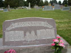
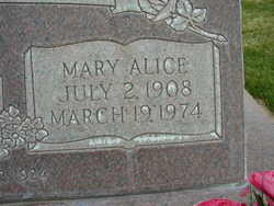
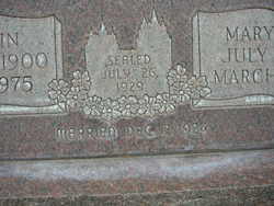
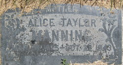
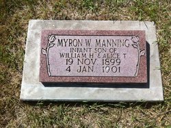
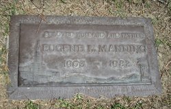
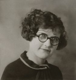
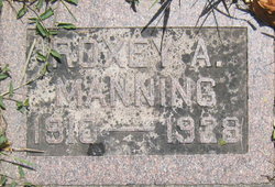
Mary Alice Manning Rosenbaum
| Birth | : | 2 Jul 1908 La Grande, Union County, Oregon, USA |
| Death | : | 19 Mar 1974 Provo, Utah County, Utah, USA |
| Burial | : | Spanish Fork City Cemetery, Spanish Fork, Utah County, USA |
| Coordinate | : | 40.1022200, -111.6471700 |
| Plot | : | 14.20 .19 |
| Description | : | link to wife contributed by member D.Shelley 7103546 link to parents provided by member J.Bryant 46798680 SpanFork interment list shows that her husband, "ROSENBAUM, BENNIE", owns this and his own, but no other burial plots in this cemetery, and no personal info abt either husband or wife |
frequently asked questions (FAQ):
-
Where is Mary Alice Manning Rosenbaum's memorial?
Mary Alice Manning Rosenbaum's memorial is located at: Spanish Fork City Cemetery, Spanish Fork, Utah County, USA.
-
When did Mary Alice Manning Rosenbaum death?
Mary Alice Manning Rosenbaum death on 19 Mar 1974 in Provo, Utah County, Utah, USA
-
Where are the coordinates of the Mary Alice Manning Rosenbaum's memorial?
Latitude: 40.1022200
Longitude: -111.6471700
Family Members:
Parent
Spouse
Siblings
Children
Flowers:


Nearby Cemetories:
1. Spanish Fork City Cemetery
Spanish Fork, Utah County, USA
Coordinate: 40.1022200, -111.6471700
2. Pioneer Heritage Cemetery
Spanish Fork, Utah County, USA
Coordinate: 40.0855000, -111.6291000
3. Evergreen Cemetery
Springville, Utah County, USA
Coordinate: 40.1399994, -111.6022034
4. Mapleton Cemetery
Mapleton, Utah County, USA
Coordinate: 40.1304300, -111.5868000
5. Joseph B Law Memorial
Mapleton, Utah County, USA
Coordinate: 40.1303700, -111.5857400
6. Historic Springville Cemetery
Springville, Utah County, USA
Coordinate: 40.1593610, -111.6148500
7. Salem City Cemetery
Salem, Utah County, USA
Coordinate: 40.0388985, -111.6694031
8. Benjamin Cemetery
Benjamin, Utah County, USA
Coordinate: 40.0769005, -111.7311020
9. Payson City Cemetery
Payson, Utah County, USA
Coordinate: 40.0489800, -111.7199000
10. Find a Grave Test Cemetery - Elk Ridge
Elk Ridge, Utah County, USA
Coordinate: 40.0143435, -111.6829070
11. Blackhawk Cemetery
Spring Lake, Utah County, USA
Coordinate: 40.0070000, -111.7455700
12. Provo City Cemetery
Provo, Utah County, USA
Coordinate: 40.2249985, -111.6444016
13. Spring Lake Cemetery
Utah County, USA
Coordinate: 40.0011000, -111.7502200
14. Fort Field Graveyard (Defunct)
Provo, Utah County, USA
Coordinate: 40.2354270, -111.6943720
15. Temple Hill Cemetery (Defunct)
Provo, Utah County, USA
Coordinate: 40.2452820, -111.6536140
16. Grandview Hill Pioneer Cemetery
Provo, Utah County, USA
Coordinate: 40.2579140, -111.6767170
17. Santaquin City Cemetery
Santaquin, Utah County, USA
Coordinate: 39.9700012, -111.7818985
18. East Lawn Memorial Hills Cemetery
Provo, Utah County, USA
Coordinate: 40.2938995, -111.6461029
19. Genola City Cemetery
Genola, Utah County, USA
Coordinate: 39.9823000, -111.8453000
20. Old Rocky Ridge Cemetery
Mona, Juab County, USA
Coordinate: 39.9382300, -111.8272900
21. Timpanogos Memorial Gardens
Orem, Utah County, USA
Coordinate: 40.3156200, -111.6856900
22. Christmas Tree Cemetery (Defunct)
Provo, Utah County, USA
Coordinate: 40.3202450, -111.6435470
23. Orem City Cemetery
Orem, Utah County, USA
Coordinate: 40.3224983, -111.6731033
24. Rocky Ridge Cemetery
Juab County, USA
Coordinate: 39.9265200, -111.8262600