
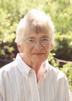

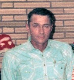
Mary Ann Fitzgerald Engdahl
| Birth | : | 24 Jan 1935 Montana, USA |
| Death | : | 14 Oct 2020 Jordan, Garfield County, Montana, USA |
| Burial | : | Pioneer Cemetery, Jordan, Garfield County, USA |
| Coordinate | : | 47.3244019, -106.9238968 |
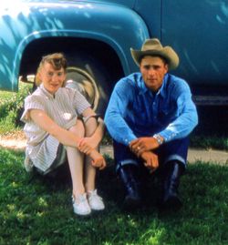
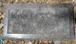
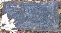
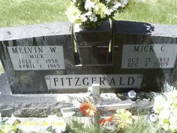
| Description | : | Adapt from Stevenson and Sons Funeral Home 10/23/2020 Mary Ann Engdahl, 85, of Jordan, passed away at home on October 14, 2020. She was born on January 24, 1935, the eldest of eight children, to the late Melvin “Mel” and Mary (Milroy) FitzGerald, in Fort Peck, Montana. The family lived on the homestead at Flat Creek until after Mary Ann’s 8th grade graduation in 1949. They sold their home and moved to Charlo, Montana where she graduated High School in 1953. She was active in 4-H and her favorite subjects in school were Home... Read More |
frequently asked questions (FAQ):
-
Where is Mary Ann Fitzgerald Engdahl's memorial?
Mary Ann Fitzgerald Engdahl's memorial is located at: Pioneer Cemetery, Jordan, Garfield County, USA.
-
When did Mary Ann Fitzgerald Engdahl death?
Mary Ann Fitzgerald Engdahl death on 14 Oct 2020 in Jordan, Garfield County, Montana, USA
-
Where are the coordinates of the Mary Ann Fitzgerald Engdahl's memorial?
Latitude: 47.3244019
Longitude: -106.9238968
Family Members:
Parent
Spouse
Siblings

Children

Flowers:


Nearby Cemetories:
1. Pioneer Cemetery
Jordan, Garfield County, USA
Coordinate: 47.3244019, -106.9238968
2. Greenridge Cemetery
Jordan, Garfield County, USA
Coordinate: 47.3389015, -106.8946991
3. Hinther Cemetery
Garfield County, USA
Coordinate: 47.2685000, -107.0218000
4. Butte Creek Cemetery
Garfield County, USA
Coordinate: 47.4777985, -107.2341995
5. Steve Forks Cemetery
Garfield County, USA
Coordinate: 47.2627983, -107.3321991
6. Cohagen Cemetery
Cohagen, Garfield County, USA
Coordinate: 47.0772018, -106.6232986
7. Darnall-Armbruster-Hubbard Family Cemetery
Garfield County, USA
Coordinate: 47.6407000, -107.0645200
8. Neudorfer Cemetery
Jordan, Garfield County, USA
Coordinate: 47.2095000, -106.2772000
9. Hearts at Peace Cemetery
Brusett, Garfield County, USA
Coordinate: 47.5441900, -107.5399200
10. Wolf Cemetery
Garfield County, USA
Coordinate: 47.1528015, -107.5924988
11. Vanstel Cemetery
Rosebud County, USA
Coordinate: 46.7872009, -106.8942032
12. Haglunds Ritchie Cemetery
McCone County, USA
Coordinate: 47.3246994, -106.0639038
13. Biebers Cemetery
McCone County, USA
Coordinate: 47.2386100, -106.0348800
14. Biebers Cemetery
McCone County, USA
Coordinate: 47.2257600, -106.0220400
15. Watkins Cemetery
McCone County, USA
Coordinate: 47.1808014, -105.9811020
16. Coon Cemetery
Garfield County, USA
Coordinate: 47.3263790, -107.9323320
17. Gilfeather Cemetery
Benzien, Garfield County, USA
Coordinate: 47.2348310, -107.9476920
18. Fort Peck Cemetery
Valley County, USA
Coordinate: 48.0069008, -106.4599991
19. Rock Springs Cemetery
Rock Springs, Rosebud County, USA
Coordinate: 46.7847800, -106.1411500
20. Fort Peck Dam Disaster Memorial
Valley County, USA
Coordinate: 48.0083000, -106.4003000
21. Brockway Cemetery
McCone County, USA
Coordinate: 47.2963982, -105.7514038
22. Brost Cemetery
McCone County, USA
Coordinate: 47.2971992, -105.7457962
23. Galpin Cemetery
Valley County, USA
Coordinate: 48.0732994, -106.4692001
24. Sumatra Cemetery
Rosebud County, USA
Coordinate: 46.6136017, -107.5674973