
| Birth | : | 7 Feb 1846 Grinton, Richmondshire District, North Yorkshire, England |
| Death | : | 7 Jul 1929 Le Mars, Plymouth County, Iowa, USA |
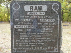
| Burial | : | Paton Cemetery, Paton, Greene County, USA |
| Coordinate | : | 42.1624985, -94.2433014 |
| Plot | : | Block 10 Lot 4 |
| Description | : | PIONEER WOMAN DIES ON BIRTHDAY MRS. ANN HODGSON WAS RESIDENT HERE FORTY-FIVE YEARS Mrs. Ann Hodgson, an old resident of Plymouth county, died at the home of her brother-in-law, Albert Muxlow, in this city July 7. Mrs. Hodgson had been in failing health for about five years and June 15 suffered a fall, which confined her to bed. On the morning of June 19 a stroke of paralysis came from which she was unable to rally and Jesus released her from her earthly cares on the morning of her eighty-third birthday. Mary Ann Raw, daughter of James... Read More |
frequently asked questions (FAQ):
-
Where is Mary Ann “Mollie” Raw Hodgson's memorial?
Mary Ann “Mollie” Raw Hodgson's memorial is located at: Paton Cemetery, Paton, Greene County, USA.
-
When did Mary Ann “Mollie” Raw Hodgson death?
Mary Ann “Mollie” Raw Hodgson death on 7 Jul 1929 in Le Mars, Plymouth County, Iowa, USA
-
Where are the coordinates of the Mary Ann “Mollie” Raw Hodgson's memorial?
Latitude: 42.1624985
Longitude: -94.2433014
Family Members:
Parent
Spouse

Siblings
Children
Flowers:


Nearby Cemetories:
1. Paton Cemetery
Paton, Greene County, USA
Coordinate: 42.1624985, -94.2433014
2. Dawson Cemetery
Paton, Greene County, USA
Coordinate: 42.1655998, -94.3283005
3. Renner Cemetery
Boone County, USA
Coordinate: 42.1380420, -94.1256570
4. Lost Grove Cemetery
Harcourt, Webster County, USA
Coordinate: 42.2583008, -94.2331009
5. Swedish Lutheran Church Cemetery
Dayton, Webster County, USA
Coordinate: 42.2175000, -94.1065000
6. Lawn Cemetery
Boone County, USA
Coordinate: 42.1771011, -94.0867996
7. Union Cemetery
Boxholm, Boone County, USA
Coordinate: 42.1369019, -94.0852966
8. Grand Ridge Cemetery
Beaver, Boone County, USA
Coordinate: 42.0786018, -94.1157990
9. Gowrie Township Cemetery
Gowrie, Webster County, USA
Coordinate: 42.2813988, -94.3043976
10. Mount Calvary Cemetery
Grand Junction, Greene County, USA
Coordinate: 42.0266000, -94.2325000
11. Beaver Cemetery
Beaver, Boone County, USA
Coordinate: 42.0462000, -94.1446000
12. Junction Township Cemetery
Grand Junction, Greene County, USA
Coordinate: 42.0236015, -94.2593994
13. Maple Grove Cemetery
Boxholm, Boone County, USA
Coordinate: 42.0793690, -94.0859890
14. Maas Cemetery
Boone County, USA
Coordinate: 42.0908012, -94.0618973
15. Pilot Mound Cemetery
Pilot Mound, Boone County, USA
Coordinate: 42.1636200, -94.0282600
16. Christ the King Catholic Cemetery
Dayton, Webster County, USA
Coordinate: 42.2601929, -94.0727539
17. Dayton Cemetery
Dayton, Webster County, USA
Coordinate: 42.2675000, -94.0755000
18. Highland Township Cemetery
Churdan, Greene County, USA
Coordinate: 42.1518310, -94.4699120
19. Saint Joseph Cemetery
Jefferson, Greene County, USA
Coordinate: 42.0289001, -94.3818970
20. Reading Cemetery
Farnhamville, Calhoun County, USA
Coordinate: 42.2593994, -94.4325027
21. Jefferson Cemetery
Jefferson, Greene County, USA
Coordinate: 42.0133018, -94.3591995
22. Runyan Cemetery
Pilot Mound, Boone County, USA
Coordinate: 42.1749992, -94.0015030
23. Our Saviour Cemetery
Callender, Webster County, USA
Coordinate: 42.3396988, -94.3153000
24. Linn Cemetery
Pilot Mound, Boone County, USA
Coordinate: 42.2045330, -93.9970230