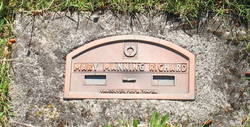
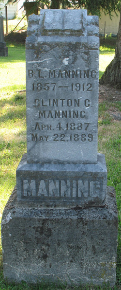
Mary Catherine Higdon Manning Richards
| Birth | : | 21 Sep 1865 Coffey County, Kansas, USA |
| Death | : | 12 Jul 1942 Vancouver, Clark County, Washington, USA |
| Burial | : | New Ellis Chapel Cemetery, Esty, Greenbrier County, USA |
| Coordinate | : | 38.0532410, -80.3836280 |
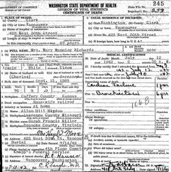
| Description | : | 1. Mary C. Higdon married Boise L. Manning in September 1883 in Clark County, Washington. NOTE: Marriage affidavit dated 24 September 1883. ================ On 30 April 1887 B. L. Manning (30), [wife] M. C. (21), [infant sons;] C. A.? (0) and C. C. (0) lived in Clarke County, Washington Territory. NOTE: The two male children must have been twins. ================ 2. Mary C. Manning (51) married Chas. R. Richards (51) in June 1916 in Clarke County, Washington. NOTE: Marriage affidavit dated 19 June 1916. ================ Washington, U.S., Select Death Certificates, 1907-1960 Name: Mary Manning Richards [Mary Manning Higdon] |
frequently asked questions (FAQ):
-
Where is Mary Catherine Higdon Manning Richards's memorial?
Mary Catherine Higdon Manning Richards's memorial is located at: New Ellis Chapel Cemetery, Esty, Greenbrier County, USA.
-
When did Mary Catherine Higdon Manning Richards death?
Mary Catherine Higdon Manning Richards death on 12 Jul 1942 in Vancouver, Clark County, Washington, USA
-
Where are the coordinates of the Mary Catherine Higdon Manning Richards's memorial?
Latitude: 38.0532410
Longitude: -80.3836280
Family Members:
Parent
Spouse
Siblings
Children
Flowers:
Nearby Cemetories:
1. New Ellis Chapel Cemetery
Esty, Greenbrier County, USA
Coordinate: 38.0532410, -80.3836280
2. Beulah Church Cemetery
Greenbrier County, USA
Coordinate: 38.0939460, -80.3471070
3. McMillion Church Cemetery
Friars Hill, Greenbrier County, USA
Coordinate: 38.0141230, -80.4261660
4. Spring Creek Presbyterian Cemetery
Falling Spring, Greenbrier County, USA
Coordinate: 37.9927406, -80.3609772
5. Sunset Cemetery
Jacox, Pocahontas County, USA
Coordinate: 38.0928001, -80.3022003
6. Kellison Cemetery
Jacox, Pocahontas County, USA
Coordinate: 38.0922012, -80.2932968
7. Whiting Cemetery
Droop, Pocahontas County, USA
Coordinate: 38.1004600, -80.2727400
8. Pilgrim's Rest Cemetery
Frankford, Greenbrier County, USA
Coordinate: 37.9514780, -80.4070260
9. Richard Hill Cemetery
Pocahontas County, USA
Coordinate: 38.1219160, -80.2832880
10. Old Droop Church Cemetery
Beard, Pocahontas County, USA
Coordinate: 38.0627230, -80.2465220
11. McCarty Cemetery
Droop, Pocahontas County, USA
Coordinate: 38.1142120, -80.2630630
12. Mount Vernon Cemetery
Frankford, Greenbrier County, USA
Coordinate: 37.9453290, -80.4272010
13. Emanuel Cemetery
Lobelia, Pocahontas County, USA
Coordinate: 38.1420060, -80.2880320
14. Gilboa Cemetery
Frankford, Greenbrier County, USA
Coordinate: 37.9295670, -80.3643330
15. Bruffy's Creek Cemetery
Hillsboro, Pocahontas County, USA
Coordinate: 38.1401599, -80.2689847
16. Frankford United Methodist Church Cemetery
Frankford, Greenbrier County, USA
Coordinate: 37.9243310, -80.3837400
17. Frankford Presbyterian Church Cemetery
Frankford, Greenbrier County, USA
Coordinate: 37.9235810, -80.3846220
18. Wesley Memorial Chapel Cemetery
Frankford, Greenbrier County, USA
Coordinate: 37.9288570, -80.4423060
19. Denmar Sanitarium Cemetery
Denmar, Pocahontas County, USA
Coordinate: 38.0892400, -80.2200300
20. Frankford Cemetery
Frankford, Greenbrier County, USA
Coordinate: 37.9191704, -80.3837967
21. Coleman Family Cemetery
Frankford, Greenbrier County, USA
Coordinate: 37.9165200, -80.3393530
22. Baldwin Family Burial Ground
Frankford, Greenbrier County, USA
Coordinate: 37.9099170, -80.3524600
23. Oak Grove Cemetery
Hillsboro, Pocahontas County, USA
Coordinate: 38.1226860, -80.2151660
24. Enon Baptist Church Cemetery
Frankford, Greenbrier County, USA
Coordinate: 37.9004300, -80.3564750

