
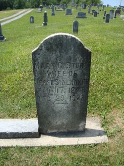
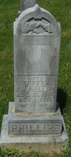
Mary Catherine “Mollie” Sturm Stalnaker
| Birth | : | 17 Feb 1848 Barbour County, West Virginia, USA |
| Death | : | 29 Dec 1923 Barbour County, West Virginia, USA |
| Burial | : | Meeting House Hill Cemetery, West Springfield, Hampden County, USA |
| Coordinate | : | 42.1142930, -72.6253960 |
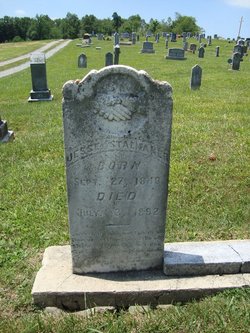
| Description | : | Married Jan. 14, 1869 in Barbour Co, WV to Jesse Stalnaker son of Henry Stalnaker and Hannah Vannoy Stalnaker. Mary was the daughter of Jacob Sturm and Lettice Ann Poling Sturm. |
frequently asked questions (FAQ):
-
Where is Mary Catherine “Mollie” Sturm Stalnaker's memorial?
Mary Catherine “Mollie” Sturm Stalnaker's memorial is located at: Meeting House Hill Cemetery, West Springfield, Hampden County, USA.
-
When did Mary Catherine “Mollie” Sturm Stalnaker death?
Mary Catherine “Mollie” Sturm Stalnaker death on 29 Dec 1923 in Barbour County, West Virginia, USA
-
Where are the coordinates of the Mary Catherine “Mollie” Sturm Stalnaker's memorial?
Latitude: 42.1142930
Longitude: -72.6253960
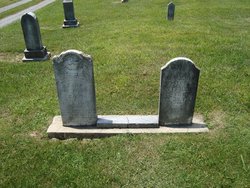
Family Members:
Spouse
Children
Flowers:


Nearby Cemetories:
1. Meeting House Hill Cemetery
West Springfield, Hampden County, USA
Coordinate: 42.1142930, -72.6253960
2. Beth El Cemetery
West Springfield, Hampden County, USA
Coordinate: 42.1095730, -72.6353040
3. Park Street Cemetery
West Springfield, Hampden County, USA
Coordinate: 42.1062460, -72.6195540
4. Congregation Kodimoh Cemetery
West Springfield, Hampden County, USA
Coordinate: 42.1092070, -72.6363660
5. Bnai Jacob Cemetery
West Springfield, Hampden County, USA
Coordinate: 42.1091040, -72.6368590
6. Beth Israel Cemetery
West Springfield, Hampden County, USA
Coordinate: 42.1096992, -72.6374969
7. Saint Thomas Cemetery
West Springfield, Hampden County, USA
Coordinate: 42.1096992, -72.6402969
8. Old Meadow Cemetery
West Springfield, Hampden County, USA
Coordinate: 42.1016350, -72.6147820
9. Sacred Heart Churchyard
Springfield, Hampden County, USA
Coordinate: 42.1122640, -72.5957250
10. Saint Matthew Cemetery
Springfield, Hampden County, USA
Coordinate: 42.1310680, -72.6003280
11. Calvary Cemetery
Chicopee, Hampden County, USA
Coordinate: 42.1347008, -72.6042023
12. Ashley Cemetery
West Springfield, Hampden County, USA
Coordinate: 42.1403008, -72.6278000
13. Mount Calvary Cemetery
West Springfield, Hampden County, USA
Coordinate: 42.1415800, -72.6309200
14. Old Burying Ground (Defunct)
Springfield, Hampden County, USA
Coordinate: 42.1014190, -72.5879840
15. Saint Benedict's Cemetery
Springfield, Hampden County, USA
Coordinate: 42.1194000, -72.5841980
16. Saint Augustine Mortuary Chapel
Springfield, Hampden County, USA
Coordinate: 42.1043400, -72.5845200
17. Old North Burying Ground
Agawam, Hampden County, USA
Coordinate: 42.0825005, -72.6207962
18. Saint Michaels Churchyard
Springfield, Hampden County, USA
Coordinate: 42.1040970, -72.5841540
19. Holy Name of Jesus Churchyard
Chicopee, Hampden County, USA
Coordinate: 42.1446810, -72.6052570
20. Fairview Cemetery
Chicopee, Hampden County, USA
Coordinate: 42.1389008, -72.5894012
21. Holy Mother of the Rosary Cemetery
Chicopee, Hampden County, USA
Coordinate: 42.1411018, -72.5916977
22. Maple Grove Cemetery
Chicopee, Hampden County, USA
Coordinate: 42.1478004, -72.6027985
23. Springfield Cemetery
Springfield, Hampden County, USA
Coordinate: 42.1015180, -72.5764990
24. Paucatuck Cemetery
West Springfield, Hampden County, USA
Coordinate: 42.1104100, -72.6796600