


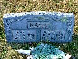
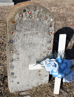
Mary Eliza Cain Nash
| Birth | : | 6 Apr 1891 Sullivan, Franklin County, Missouri, USA |
| Death | : | 5 Mar 1967 Bonne Terre, St. Francois County, Missouri, USA |
| Burial | : | Island Cemetery, Newport, Newport County, USA |
| Coordinate | : | 41.4956589, -71.3135605 |
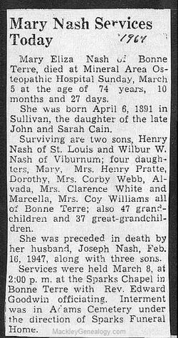
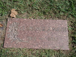
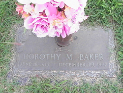
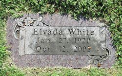
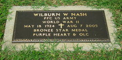
| Description | : | Mary Eliza "Liza" Nash of Bonne Terre, died at Mineral Area Osteopathic Hospital, Sunday, March 5th, 1964, at the age of 74 years, 10 months, and 27 days. She was born April 6, 1891 in Sullivan, the daughter of the late John and Sarah Cain. Surviving are two sons, Henry Nash of St. Louis, and Wilber W. Nash of Viburnum; four daughters, Mary, Mrs. Henry Pratte; Dorothy, Mrs. Corby Webb; Alvada, Mrs. Clarence White; and Marcella, Mrs. Coy Williams, all of Bonne Terre, also 47 grandchildren, and 37 great-grandchildren. She was prededed in death by her husband, Joseph Woodson "Woods"... Read More |
frequently asked questions (FAQ):
-
Where is Mary Eliza Cain Nash's memorial?
Mary Eliza Cain Nash's memorial is located at: Island Cemetery, Newport, Newport County, USA.
-
When did Mary Eliza Cain Nash death?
Mary Eliza Cain Nash death on 5 Mar 1967 in Bonne Terre, St. Francois County, Missouri, USA
-
Where are the coordinates of the Mary Eliza Cain Nash's memorial?
Latitude: 41.4956589
Longitude: -71.3135605
Family Members:
Parent
Spouse
Siblings
Children

Flowers:


Nearby Cemetories:
1. Island Cemetery
Newport, Newport County, USA
Coordinate: 41.4956589, -71.3135605
2. Saint Marys Cemetery
Newport, Newport County, USA
Coordinate: 41.4971085, -71.3135147
3. Friends Cemetery
Newport, Newport County, USA
Coordinate: 41.4934807, -71.3136826
4. God's Little Acre Cemetery
Newport, Newport County, USA
Coordinate: 41.4965150, -71.3163130
5. Willow Cemetery
Newport, Newport County, USA
Coordinate: 41.4949890, -71.3164650
6. Common Burying Ground
Newport, Newport County, USA
Coordinate: 41.4959564, -71.3165741
7. Braman Cemetery
Newport, Newport County, USA
Coordinate: 41.4956360, -71.3169098
8. John Clarke Cemetery
Newport, Newport County, USA
Coordinate: 41.4937897, -71.3112869
9. Coddington Cemetery
Newport, Newport County, USA
Coordinate: 41.4923706, -71.3143616
10. North Burial Ground
Newport, Newport County, USA
Coordinate: 41.4981270, -71.3170700
11. Bliss-Pierce Lot
Newport, Newport County, USA
Coordinate: 41.4941140, -71.3090260
12. Malboro Street Tomb (Defunct)
Newport, Newport County, USA
Coordinate: 41.4911110, -71.3136110
13. Barney Street Cemetery
Newport, Newport County, USA
Coordinate: 41.4893608, -71.3109818
14. First Sabbatarian Church of Newport Cemetery
Newport, Newport County, USA
Coordinate: 41.4891701, -71.3116379
15. Dyre Family Burial Ground (Defunct)
Newport, Newport County, USA
Coordinate: 41.5016070, -71.3209220
16. Trinity Church Cemetery
Newport, Newport County, USA
Coordinate: 41.4874229, -71.3131180
17. Colonial Jewish Cemetery of Rhode Island
Newport, Newport County, USA
Coordinate: 41.4879265, -71.3093567
18. Moravian Church Lot
Newport, Newport County, USA
Coordinate: 41.4874190, -71.3113130
19. First Congregational Churchyard (Defunct)
Newport, Newport County, USA
Coordinate: 41.4864020, -71.3119910
20. Judge Anthony Wilbur Cemetery
Newport, Newport County, USA
Coordinate: 41.4989600, -71.3018300
21. Governor Arnold Burying Ground
Newport, Newport County, USA
Coordinate: 41.4861300, -71.3119900
22. Newport Congregational Church Cemetery
Newport, Newport County, USA
Coordinate: 41.4857674, -71.3128662
23. Goat Island Pirate Graves
Newport, Newport County, USA
Coordinate: 41.4928600, -71.3269300
24. Goat Island Burial Ground
Newport, Newport County, USA
Coordinate: 41.4930330, -71.3272510