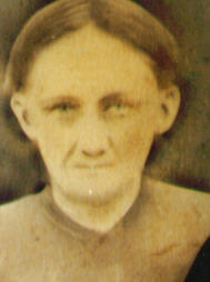
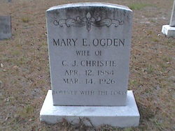
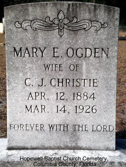
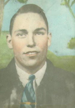
Mary Elizabeth Ogburn Christie
| Birth | : | 12 Apr 1884 Georgia, USA |
| Death | : | 14 Mar 1926 Benton, Columbia County, Florida, USA |
| Burial | : | Saint Mark Cemetery, Jamestown, Newport County, USA |
| Coordinate | : | 41.5300800, -71.3657500 |
| Description | : | Mary Elizabeth Ogburn was the 2nd wife of Charles J. Christie. They were married on July 29, 1906 by the County Judge in Hamilton County, Fl. They had eight children: Zola Christie b.Feb. 18,1908,L.D.Christie b.Apr. 09, 1909,Addie Mae Christie b.Mar. 12, 1912,George Christie b.June 19, 1915,Raymond Christie b.Dec. 09, 1916,Clyde Price Christie b.Apr. 08, 1919, Herbert Christie b.Feb.12,1920, and Mary Elizabeth Christie b.May 14, 1926. Mary reportedly died giving birth to this last child. The child was kept by her 1/2 brother, William A. Christie , but died at a very young age. Mary Ogburn was previously married to W.A.M.... Read More |
frequently asked questions (FAQ):
-
Where is Mary Elizabeth Ogburn Christie's memorial?
Mary Elizabeth Ogburn Christie's memorial is located at: Saint Mark Cemetery, Jamestown, Newport County, USA.
-
When did Mary Elizabeth Ogburn Christie death?
Mary Elizabeth Ogburn Christie death on 14 Mar 1926 in Benton, Columbia County, Florida, USA
-
Where are the coordinates of the Mary Elizabeth Ogburn Christie's memorial?
Latitude: 41.5300800
Longitude: -71.3657500
Family Members:
Parent
Spouse
Siblings
Children
Flowers:
Nearby Cemetories:
1. Saint Mark Cemetery
Jamestown, Newport County, USA
Coordinate: 41.5300800, -71.3657500
2. George F. Gardiner Farm Cemetery
Jamestown, Newport County, USA
Coordinate: 41.5314460, -71.3753960
3. Tew Cemetery
Jamestown, Newport County, USA
Coordinate: 41.5314816, -71.3757173
4. Governor Carr Lot
Jamestown, Newport County, USA
Coordinate: 41.5205420, -71.3659670
5. Watson Lot (Defunct)
Jamestown, Newport County, USA
Coordinate: 41.5264600, -71.3822800
6. Cedar Cemetery
Jamestown, Newport County, USA
Coordinate: 41.5264664, -71.3822861
7. Hazard Lot
Jamestown, Newport County, USA
Coordinate: 41.5265300, -71.3831500
8. Friends Cemetery
Jamestown, Newport County, USA
Coordinate: 41.5262489, -71.3833771
9. Quaker Records
Jamestown, Newport County, USA
Coordinate: 41.5262740, -71.3840550
10. Paine Cemetery
Jamestown, Newport County, USA
Coordinate: 41.5592170, -71.3635900
11. Cautantowwits Indian Lot
Jamestown, Newport County, USA
Coordinate: 41.4986940, -71.3800830
12. Town Cemetery
Jamestown, Newport County, USA
Coordinate: 41.4965300, -71.3745200
13. Dutch Island Small Pox Lot (Defunct)
Washington County, USA
Coordinate: 41.5049310, -71.3971470
14. Saint Matthew’s Memorial Garden
Jamestown, Newport County, USA
Coordinate: 41.4959550, -71.3738060
15. Central Baptist Church Memorial Garden
Jamestown, Newport County, USA
Coordinate: 41.4958840, -71.3743750
16. Coasters Harbor Cemetery
Newport, Newport County, USA
Coordinate: 41.5078500, -71.3269600
17. Fort Greble Post Cemetery (Defunct)
Jamestown, Newport County, USA
Coordinate: 41.5030556, -71.4005556
18. Joseph Greene Lot
Jamestown, Newport County, USA
Coordinate: 41.4924200, -71.3727520
19. David Greene Lot
North Kingstown, Washington County, USA
Coordinate: 41.5324500, -71.4222100
20. Cottrell-Green Cemetery
Jamestown, Newport County, USA
Coordinate: 41.4908000, -71.3894870
21. Dyre Family Burial Ground (Defunct)
Newport, Newport County, USA
Coordinate: 41.5016070, -71.3209220
22. John Congdon Lot
North Kingstown, Washington County, USA
Coordinate: 41.5138610, -71.4240560
23. Arnold Lot
Jamestown, Newport County, USA
Coordinate: 41.4869120, -71.3899760
24. Goat Island Burial Ground
Newport, Newport County, USA
Coordinate: 41.4930330, -71.3272510

