
| Birth | : | 6 Jun 1831 Virginia, USA |
| Death | : | 6 Dec 1877 Iowa, USA |
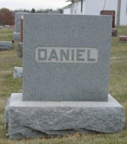
| Burial | : | Hopeville Cemetery, Hopeville, Clarke County, USA |
| Coordinate | : | 40.9450000, -93.9870000 |
| Plot | : | 07-33 |
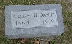
| Description | : | Daughter of Booker T. Witt and Mary Ann Parker Witt Adkins. She married Joseph Washington Daniel on 20 December 1849. Their children were John "Milton" Daniel[married Lillie C. Williamson & Susie Homewood], Emma A. Daniel[married Elijah Emery], Charles Parker Daniel[married Rebecca E. Dixon], Albert Daniel[married Sarah I. Dixon], Evalina "Eva" Daniel[married Jacob S. Banker], William H. Daniel[married Nellie F. Tinker], Ella Daniel[married Amos R. Burnett], Elijah Witt Daniel[married Mary A. Adkins] and Mary Elizabeth Daniel. She died age 46 years and 6 months. |
frequently asked questions (FAQ):
-
Where is Mary Elizabeth Witt Daniel's memorial?
Mary Elizabeth Witt Daniel's memorial is located at: Hopeville Cemetery, Hopeville, Clarke County, USA.
-
When did Mary Elizabeth Witt Daniel death?
Mary Elizabeth Witt Daniel death on 6 Dec 1877 in Iowa, USA
-
Where are the coordinates of the Mary Elizabeth Witt Daniel's memorial?
Latitude: 40.9450000
Longitude: -93.9870000
Family Members:
Parent

Spouse
Siblings
Children
Flowers:


Nearby Cemetories:
1. Hopeville Cemetery
Hopeville, Clarke County, USA
Coordinate: 40.9450000, -93.9870000
2. Olinger Cemetery
Union County, USA
Coordinate: 40.9690208, -94.0274887
3. Gregg Cemetery
Doyle Township, Clarke County, USA
Coordinate: 40.9138000, -93.9520000
4. Leas Cemetery
Union County, USA
Coordinate: 40.9080009, -94.0220032
5. Homewood Cemetery
Thayer, Union County, USA
Coordinate: 40.9220009, -94.0419998
6. Oak Hill Cemetery
Thayer, Union County, USA
Coordinate: 40.9183100, -94.0530100
7. Westerville Cemetery
Grand River, Decatur County, USA
Coordinate: 40.8824606, -93.9666116
8. Warrick Cemetery
Decatur County, USA
Coordinate: 40.8960000, -93.9234000
9. Sanders Cemetery
Doyle Township, Clarke County, USA
Coordinate: 40.9730000, -93.9016000
10. Claypool Cemetery
Thayer, Union County, USA
Coordinate: 41.0126114, -94.0303497
11. OGrady Cemetery
Decatur County, USA
Coordinate: 40.8643990, -93.9907990
12. Westervelt Cemetery
Grand River, Decatur County, USA
Coordinate: 40.8630955, -93.9753771
13. Wheelis Cemetery
Grand River, Decatur County, USA
Coordinate: 40.8755000, -93.9215000
14. Murray Cemetery
Murray, Clarke County, USA
Coordinate: 41.0278015, -93.9456024
15. Lacelle Cemetery
Clarke County, USA
Coordinate: 40.9446500, -93.8690300
16. Otterbein Cemetery
Thayer, Union County, USA
Coordinate: 40.9990005, -94.0879974
17. West Union Cemetery
Thayer, Union County, USA
Coordinate: 41.0191994, -94.0721970
18. Pumptown Cemetery
Union Township, Ringgold County, USA
Coordinate: 40.8670000, -94.0667000
19. Thayer Catholic Cemetery
Thayer, Union County, USA
Coordinate: 41.0374985, -94.0357971
20. Cornwall Cemetery
Thayer, Union County, USA
Coordinate: 40.9047165, -94.1102295
21. Abel Cemetery
Arispe, Union County, USA
Coordinate: 40.9790001, -94.1429977
22. McKee Cemetery
Decatur County, USA
Coordinate: 40.8647000, -93.8622000
23. Young Cemetery
Grand River, Decatur County, USA
Coordinate: 40.8255172, -93.9424396
24. Bell Family Cemetery
Murray, Clarke County, USA
Coordinate: 41.0625267, -93.9240036