
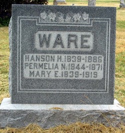
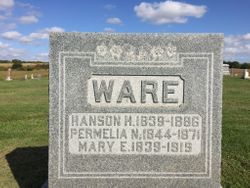
Mary Ellenor Branson Ware
| Birth | : | 3 Feb 1839 Ohio, USA |
| Death | : | 11 Jul 1919 Quitman, Nodaway County, Missouri, USA |
| Burial | : | Rosebud Lutheran Cemetery, Shadehill, Perkins County, USA |
| Coordinate | : | 45.7356500, -102.3629000 |
frequently asked questions (FAQ):
-
Where is Mary Ellenor Branson Ware's memorial?
Mary Ellenor Branson Ware's memorial is located at: Rosebud Lutheran Cemetery, Shadehill, Perkins County, USA.
-
When did Mary Ellenor Branson Ware death?
Mary Ellenor Branson Ware death on 11 Jul 1919 in Quitman, Nodaway County, Missouri, USA
-
Where are the coordinates of the Mary Ellenor Branson Ware's memorial?
Latitude: 45.7356500
Longitude: -102.3629000
Family Members:
Spouse

Children

Flowers:


Nearby Cemetories:
1. Rosebud Lutheran Cemetery
Shadehill, Perkins County, USA
Coordinate: 45.7356500, -102.3629000
2. Norwegian Cemetery
Perkins County, USA
Coordinate: 45.6972008, -102.3735962
3. Seim Cemetery
Perkins County, USA
Coordinate: 45.6819000, -102.3118973
4. Scholaas Cemetery
Shadehill, Perkins County, USA
Coordinate: 45.7984600, -102.3116100
5. Hugh Glass Memorial
Perkins County, USA
Coordinate: 45.7402900, -102.2319500
6. Pleasant Ridge Cemetery
Shadehill, Perkins County, USA
Coordinate: 45.6974983, -102.5177994
7. Pleasant Valley German Baptiste Cemetery
Perkins County, USA
Coordinate: 45.6974800, -102.5182000
8. Bison Cemetery
Bison, Perkins County, USA
Coordinate: 45.5452995, -102.4563980
9. Fredlund Cemetery
Perkins County, USA
Coordinate: 45.7188988, -102.6585999
10. Petrel Cemetery
Adams County, USA
Coordinate: 45.9455986, -102.3088989
11. Lodgepole Cemetery
Lodgepole, Perkins County, USA
Coordinate: 45.8047400, -102.6678140
12. Meadow Gallaway Cemetery
Meadow, Perkins County, USA
Coordinate: 45.5155983, -102.2149963
13. Greenhill Cemetery
Lemmon, Perkins County, USA
Coordinate: 45.9328003, -102.1568985
14. Holland Center Cemetery
Lodgepole, Perkins County, USA
Coordinate: 45.7347000, -102.7246400
15. Haynes Cemetery
Haynes, Adams County, USA
Coordinate: 45.9728012, -102.4955978
16. North Lemmon Cemetery
Petrel, Adams County, USA
Coordinate: 45.9959900, -102.2458800
17. Duck Creek Lutheran Cemetery
Perkins County, USA
Coordinate: 45.7756780, -102.7772550
18. Hettinger Cemetery
Hettinger, Adams County, USA
Coordinate: 46.0018997, -102.6232986
19. Bethany Cemetery
Perkins County, USA
Coordinate: 45.8046989, -102.8199997
20. Chance Cemetery
Chance, Perkins County, USA
Coordinate: 45.4142530, -102.2728120
21. Ellingson Zion Cemetery
Perkins County, USA
Coordinate: 45.8713989, -102.8375015
22. Stowers Cemetery
Adams County, USA
Coordinate: 46.0564400, -102.1029000
23. Saint Peters Cemetery
Adams County, USA
Coordinate: 46.1055984, -102.4653015
24. Prairie City Cemetery
Prairie City, Perkins County, USA
Coordinate: 45.5307190, -102.8171290