
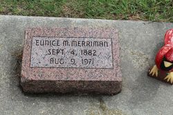

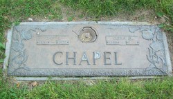
Mary Eunice Chapel Merriman
| Birth | : | 4 Sep 1882 Asherville, Mitchell County, Kansas, USA |
| Death | : | 9 Aug 1971 Woodston, Rooks County, Kansas, USA |
| Burial | : | Woodston Cemetery, Woodston, Rooks County, USA |
| Coordinate | : | 39.4375000, -99.1268997 |
| Plot | : | Unknown |
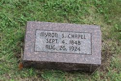
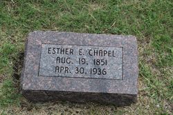
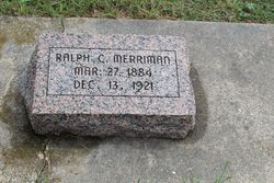
| Description | : | OBITUARY-Hill City Times, Kansas Thursday, December 23, 1971, pg 2, sec 2: R. E. Fairbanks book: Mary Eunice Merriman was born near Asherville, Kansas, September 4, 1882; and departed this life August 9, 1971, at age of 88 years, 11 months and five days. She was the daughter of Myron and Esther Darrow Chapel. Of her immediate family, consisting of four brothers and three sisters, one brother remains, Daniel Chapel of Stoneham, Colorado. She was the wife of Ralph C. Merriman who preceded her in death December 13, 1921. She was the mother of six children; Mrs. Inda Maude Hoar, who passed away... Read More |
frequently asked questions (FAQ):
-
Where is Mary Eunice Chapel Merriman's memorial?
Mary Eunice Chapel Merriman's memorial is located at: Woodston Cemetery, Woodston, Rooks County, USA.
-
When did Mary Eunice Chapel Merriman death?
Mary Eunice Chapel Merriman death on 9 Aug 1971 in Woodston, Rooks County, Kansas, USA
-
Where are the coordinates of the Mary Eunice Chapel Merriman's memorial?
Latitude: 39.4375000
Longitude: -99.1268997
Family Members:
Parent
Spouse
Siblings
Children
Flowers:


Nearby Cemetories:
1. Woodston Cemetery
Woodston, Rooks County, USA
Coordinate: 39.4375000, -99.1268997
2. Survey Cemetery
Woodston, Rooks County, USA
Coordinate: 39.3722000, -99.1333008
3. Spring Branch Cemetery
Woodston, Rooks County, USA
Coordinate: 39.5099983, -99.0580978
4. West Hope Cemetery
Rooks County, USA
Coordinate: 39.5024986, -99.2110977
5. Ash Rock Cemetery
Woodston, Rooks County, USA
Coordinate: 39.5248909, -99.0817719
6. Pleasant Valley Cemetery
Osborne County, USA
Coordinate: 39.4583015, -99.0077972
7. Johnson Cemetery
Stockton, Rooks County, USA
Coordinate: 39.3493996, -99.1941986
8. Stockton Cemetery
Stockton, Rooks County, USA
Coordinate: 39.4406700, -99.2647400
9. Saint Thomas Cemetery
Stockton, Rooks County, USA
Coordinate: 39.4449997, -99.2771988
10. Chalk Mound Cemetery
Laton, Rooks County, USA
Coordinate: 39.3208008, -99.0852966
11. Pleasant Plain Cemetery
Osborne County, USA
Coordinate: 39.3367004, -99.0372009
12. Pioneer Cemetery
Alton, Osborne County, USA
Coordinate: 39.4742012, -98.9749985
13. Mount Ayr Cemetery
Alton, Osborne County, USA
Coordinate: 39.3764000, -98.9717026
14. Old Stockton Cemetery
Stockton, Rooks County, USA
Coordinate: 39.4597015, -99.3050003
15. Bigge Family Cemetery
Stockton, Rooks County, USA
Coordinate: 39.4584700, -99.3053200
16. Grant Center Cemetery
Alton, Osborne County, USA
Coordinate: 39.5242004, -98.9708023
17. Sumner Cemetery
Alton, Osborne County, USA
Coordinate: 39.4799995, -98.9338913
18. Pleasant Ridge Cemetery
Kirwin, Phillips County, USA
Coordinate: 39.5963000, -99.1234000
19. Aurora Cemetery
Laton, Rooks County, USA
Coordinate: 39.2778015, -99.0847015
20. Greenwood Cemetery
Kirwin, Phillips County, USA
Coordinate: 39.5931900, -99.2064600
21. Bow Creek Cemetery
Glade, Phillips County, USA
Coordinate: 39.5681000, -99.2696991
22. Twin Mound Cemetery
Rooks County, USA
Coordinate: 39.2855988, -99.2319031
23. Kill Creek Cemetery
Alton, Osborne County, USA
Coordinate: 39.3805528, -98.8967658
24. Leasburg Cemetery
Cedar, Smith County, USA
Coordinate: 39.5819016, -98.9728012