

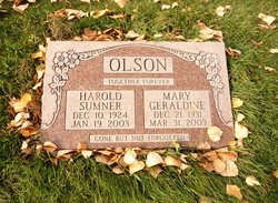
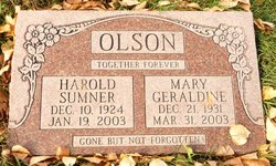
Mary Geraldine “Gerry” James Olson
| Birth | : | 21 Dec 1931 Magrath, Claresholm Census Division, Alberta, Canada |
| Death | : | 31 Mar 2003 Calgary, Calgary Census Division, Alberta, Canada |
| Burial | : | Magrath Cemetery, Magrath, Claresholm Census Division, Canada |
| Coordinate | : | 49.3985700, -112.8648700 |
| Plot | : | Block 2 Plot 31 Grave 3 |
| Description | : | MACLEOD GAZETTE - ONLINE Mary Geraldine (Gerry) Olson passed away suddenly in Calgary on Monday, March 31, 2003 at the age of 71 years. Gerry was predeceased by her beloved husband Harold in January 2003. She is survived by her five sons, 24 grandchildren; one great grandchild; her sisterand one aunt Ruth' Gerry was also predeceased by her parents, two brothers and one sister. Gerry was born in Magrath on Dec. 21, 1931. After completing Grade 11, she worked for two years in the Woolen Mills of Magrath and three years as an AGT... Read More |
frequently asked questions (FAQ):
-
Where is Mary Geraldine “Gerry” James Olson's memorial?
Mary Geraldine “Gerry” James Olson's memorial is located at: Magrath Cemetery, Magrath, Claresholm Census Division, Canada.
-
When did Mary Geraldine “Gerry” James Olson death?
Mary Geraldine “Gerry” James Olson death on 31 Mar 2003 in Calgary, Calgary Census Division, Alberta, Canada
-
Where are the coordinates of the Mary Geraldine “Gerry” James Olson's memorial?
Latitude: 49.3985700
Longitude: -112.8648700
Family Members:
Parent
Spouse
Siblings
Children

Flowers:


Nearby Cemetories:
1. Magrath Cemetery
Magrath, Claresholm Census Division, Canada
Coordinate: 49.3985700, -112.8648700
2. Hutterville Hutterite Cemetery
Magrath, Claresholm Census Division, Canada
Coordinate: 49.3503165, -112.7701038
3. Rockport Colony Cemetery
Magrath, Claresholm Census Division, Canada
Coordinate: 49.3027780, -112.8136110
4. Spring Valley Hutterite Colony Cemetery
Spring Coulee, Claresholm Census Division, Canada
Coordinate: 49.3517043, -113.0551519
5. Spring Coulee Cemetery
Spring Coulee, Claresholm Census Division, Canada
Coordinate: 49.3412100, -113.0541400
6. Temple Hill Cemetery
Raymond, Lethbridge Census Division, Canada
Coordinate: 49.4916300, -112.6605200
7. East Raymond Hutterite Colony Cemetery
Raymond, Lethbridge Census Division, Canada
Coordinate: 49.4185305, -112.5791329
8. Stirling Mennonite Church Cemetery
Stirling, Lethbridge Census Division, Canada
Coordinate: 49.4607570, -112.5387970
9. Wolf Creek Hutterite Colony Cemetery
Stirling, Lethbridge Census Division, Canada
Coordinate: 49.4119142, -112.5163705
10. Crystal Spring Hutterite Colony Cemetery
Magrath, Claresholm Census Division, Canada
Coordinate: 49.1702490, -112.8048290
11. Stirling Cemetery
Stirling, Lethbridge Census Division, Canada
Coordinate: 49.5093400, -112.5380000
12. West Raley Hutterite Cemetery
Raley, Claresholm Census Division, Canada
Coordinate: 49.2908857, -113.2283616
13. Mountain View Cemetery
Lethbridge, Lethbridge Census Division, Canada
Coordinate: 49.6800385, -112.8297729
14. Woolford Cemetery
Woolford, Claresholm Census Division, Canada
Coordinate: 49.1945800, -113.1652300
15. Wilson Siding Hutterite Cemetery
Wilson, Lethbridge Census Division, Canada
Coordinate: 49.6203914, -112.5781130
16. Indian Battle Park
Lethbridge, Lethbridge Census Division, Canada
Coordinate: 49.6928200, -112.8582900
17. Saint Catherine Cemetery
Stand Off, Claresholm Census Division, Canada
Coordinate: 49.4516900, -113.3112300
18. Big Bend Hutterite Colony
Cardston, Claresholm Census Division, Canada
Coordinate: 49.1636110, -113.1411110
19. Standoff Hutterite Colony Cemetery
Stand Off, Claresholm Census Division, Canada
Coordinate: 49.4829507, -113.3130885
20. Archmount Cemetery
Lethbridge, Lethbridge Census Division, Canada
Coordinate: 49.7057900, -112.9017500
21. Saint Patrick's Cemetery
Lethbridge, Lethbridge Census Division, Canada
Coordinate: 49.7084618, -112.8428726
22. East Cardston Hutterite Cemetery
Cardston, Claresholm Census Division, Canada
Coordinate: 49.1908348, -113.2258004
23. New Dayton Community Cemetery
New Dayton, Lethbridge Census Division, Canada
Coordinate: 49.4254300, -112.3601800
24. Royal View Memorial Cemetery
Lethbridge, Lethbridge Census Division, Canada
Coordinate: 49.7518540, -112.8242250