
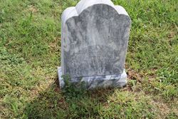
Mary Isabelle Dare Lane
| Birth | : | 7 Mar 1845 |
| Death | : | 10 Aug 1927 |
| Burial | : | Woodston Cemetery, Woodston, Rooks County, USA |
| Coordinate | : | 39.4375000, -99.1268997 |
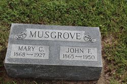
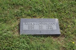
| Description | : | Mary Elizabeth [may of had two middle names] Dare was born in Fulton county, Illinois, March 7, 1845 and died in Woodston, Kansas, August 10, 1927. She was married to G. B. Lane in Ill. in 1860, and they moved to Kansas in the 70s. To this union 10 children were born, the husband and 4 children preceding her in death. Those that survive are: Mary Clarissa Musgrove, Woodston, Kans.; John Franklin Lane, Los Angeles, Calif.; James Albert Lane, Alva, Okla.; Edna Catherine Hanson, Los Angeles, Calif.; Julia Ann Cunningham, Woodston, Kans. and Florence Grace Shacklet, Seattle,... Read More |
frequently asked questions (FAQ):
-
Where is Mary Isabelle Dare Lane's memorial?
Mary Isabelle Dare Lane's memorial is located at: Woodston Cemetery, Woodston, Rooks County, USA.
-
When did Mary Isabelle Dare Lane death?
Mary Isabelle Dare Lane death on 10 Aug 1927 in
-
Where are the coordinates of the Mary Isabelle Dare Lane's memorial?
Latitude: 39.4375000
Longitude: -99.1268997
Family Members:
Spouse
Children

Flowers:


Nearby Cemetories:
1. Woodston Cemetery
Woodston, Rooks County, USA
Coordinate: 39.4375000, -99.1268997
2. Survey Cemetery
Woodston, Rooks County, USA
Coordinate: 39.3722000, -99.1333008
3. Spring Branch Cemetery
Woodston, Rooks County, USA
Coordinate: 39.5099983, -99.0580978
4. West Hope Cemetery
Rooks County, USA
Coordinate: 39.5024986, -99.2110977
5. Ash Rock Cemetery
Woodston, Rooks County, USA
Coordinate: 39.5248909, -99.0817719
6. Pleasant Valley Cemetery
Osborne County, USA
Coordinate: 39.4583015, -99.0077972
7. Johnson Cemetery
Stockton, Rooks County, USA
Coordinate: 39.3493996, -99.1941986
8. Stockton Cemetery
Stockton, Rooks County, USA
Coordinate: 39.4406700, -99.2647400
9. Saint Thomas Cemetery
Stockton, Rooks County, USA
Coordinate: 39.4449997, -99.2771988
10. Chalk Mound Cemetery
Laton, Rooks County, USA
Coordinate: 39.3208008, -99.0852966
11. Pleasant Plain Cemetery
Osborne County, USA
Coordinate: 39.3367004, -99.0372009
12. Pioneer Cemetery
Alton, Osborne County, USA
Coordinate: 39.4742012, -98.9749985
13. Mount Ayr Cemetery
Alton, Osborne County, USA
Coordinate: 39.3764000, -98.9717026
14. Old Stockton Cemetery
Stockton, Rooks County, USA
Coordinate: 39.4597015, -99.3050003
15. Bigge Family Cemetery
Stockton, Rooks County, USA
Coordinate: 39.4584700, -99.3053200
16. Grant Center Cemetery
Alton, Osborne County, USA
Coordinate: 39.5242004, -98.9708023
17. Sumner Cemetery
Alton, Osborne County, USA
Coordinate: 39.4799995, -98.9338913
18. Pleasant Ridge Cemetery
Kirwin, Phillips County, USA
Coordinate: 39.5963000, -99.1234000
19. Aurora Cemetery
Laton, Rooks County, USA
Coordinate: 39.2778015, -99.0847015
20. Greenwood Cemetery
Kirwin, Phillips County, USA
Coordinate: 39.5931900, -99.2064600
21. Bow Creek Cemetery
Glade, Phillips County, USA
Coordinate: 39.5681000, -99.2696991
22. Twin Mound Cemetery
Rooks County, USA
Coordinate: 39.2855988, -99.2319031
23. Kill Creek Cemetery
Alton, Osborne County, USA
Coordinate: 39.3805528, -98.8967658
24. Leasburg Cemetery
Cedar, Smith County, USA
Coordinate: 39.5819016, -98.9728012