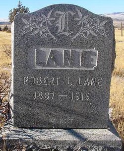
| Birth | : | 27 Apr 1892 Three Forks, Gallatin County, Montana, USA |
| Death | : | 30 May 1989 Helena, Lewis and Clark County, Montana, USA |
| Burial | : | Chesterfield Cemetery, Chesterfield, Oxford County Municipality, Canada |
| Coordinate | : | 43.2941360, -80.6680145 |
| Plot | : | M 28A2 |
| Description | : | Mamie was a dear friend whom I met when I was her CNA at Big Sky Care Center in Helena, Montana. She was well into her 90s, but oh, how vibrant and talented she was! She was the epitome of a Montana woman in my mind: Strong in body and spirit, but every bit a lady. She married John Thomas Murray on November 19, 1908 in Bozeman, Montana. They were later divorced. She married Everett Frank "Pat" Martin on July 26, 1927 in Deer Lodge, Montana. Both of her husbands died before I knew her. |
frequently asked questions (FAQ):
-
Where is Mary Jane “Mamie” Lane Martin's memorial?
Mary Jane “Mamie” Lane Martin's memorial is located at: Chesterfield Cemetery, Chesterfield, Oxford County Municipality, Canada.
-
When did Mary Jane “Mamie” Lane Martin death?
Mary Jane “Mamie” Lane Martin death on 30 May 1989 in Helena, Lewis and Clark County, Montana, USA
-
Where are the coordinates of the Mary Jane “Mamie” Lane Martin's memorial?
Latitude: 43.2941360
Longitude: -80.6680145
Family Members:
Parent
Spouse
Siblings
Children
Flowers:
Nearby Cemetories:
1. Chesterfield Cemetery
Chesterfield, Oxford County Municipality, Canada
Coordinate: 43.2941360, -80.6680145
2. Ratho Presbyterian Cemetery
Ratho, Oxford County Municipality, Canada
Coordinate: 43.2772464, -80.7046934
3. Plattsville Cemetery
Plattsville, Oxford County Municipality, Canada
Coordinate: 43.2980995, -80.6230774
4. Blandford Cemetery
Bright, Oxford County Municipality, Canada
Coordinate: 43.2573500, -80.6638000
5. South Brook Pentecostal Cemetery
South Brook, Notre Dame Bay Census Division, Canada
Coordinate: 43.3084412, -80.6133652
6. Nith Valley Mennonite Cemetery
Waterloo Regional Municipality, Canada
Coordinate: 43.3389587, -80.6824570
7. Stauffer Pioneer Cemetery
Haysville, Waterloo Regional Municipality, Canada
Coordinate: 43.3431091, -80.6617126
8. Ninth Line Evangelical Cemetery
Blandford-Blenheim, Oxford County Municipality, Canada
Coordinate: 43.2509310, -80.6276000
9. Bethel United Church Cemetery
Punkeydoodles Corners, Waterloo Regional Municipality, Canada
Coordinate: 43.3323850, -80.7279020
10. Saint James Anglican Cemetery
Waterloo Regional Municipality, Canada
Coordinate: 43.3470630, -80.7171540
11. Community Farm Of The Brethren Cemetery
Washington, Oxford County Municipality, Canada
Coordinate: 43.2941640, -80.5795874
12. Washington Cemetery
Washington, Oxford County Municipality, Canada
Coordinate: 43.3099556, -80.5771637
13. Evangelical United Brethren Cemetery
East Zorra-Tavistock, Oxford County Municipality, Canada
Coordinate: 43.3127430, -80.7619650
14. Pinehill Cemetery
Wilmot Township, Waterloo Regional Municipality, Canada
Coordinate: 43.3621580, -80.6202350
15. Windfall Cemetery
Windfall, Oxford County Municipality, Canada
Coordinate: 43.2255210, -80.6218100
16. Amish Mennonite Cemetery
East Zorra-Tavistock, Oxford County Municipality, Canada
Coordinate: 43.3497124, -80.7442780
17. Saint Matthews Lutheran Church Cemetery
Cassel, Oxford County Municipality, Canada
Coordinate: 43.3079100, -80.7763100
18. Riverside Cemetery
New Hamburg, Waterloo Regional Municipality, Canada
Coordinate: 43.3745041, -80.6974182
19. Blenheim Mennonite Cemetery
Blandford-Blenheim, Oxford County Municipality, Canada
Coordinate: 43.3360443, -80.5662155
20. Drumbo Cemetery
Drumbo, Oxford County Municipality, Canada
Coordinate: 43.2315254, -80.5883255
21. Wilmot Mennonite Cemetery
Wilmot Centre, Waterloo Regional Municipality, Canada
Coordinate: 43.3808174, -80.6583405
22. East Zorra Mennonite Cemetery
East Zorra-Tavistock, Oxford County Municipality, Canada
Coordinate: 43.3225700, -80.7862700
23. Innerkip Cemetery
Innerkip, Oxford County Municipality, Canada
Coordinate: 43.2050000, -80.6929000
24. Wilmot Centre Cemetery
Wilmot Centre, Waterloo Regional Municipality, Canada
Coordinate: 43.3853320, -80.6287850


