Mary Jean Haight
| Birth | : | 20 Jul 1960 Watertown, Codington County, South Dakota, USA |
| Death | : | 20 Jul 1960 Watertown, Codington County, South Dakota, USA |
| Burial | : | Carrieton Cemetery, Carrieton, District Council of Orroroo Carrieton, Australia |
| Coordinate | : | -32.4441100, 138.5510400 |
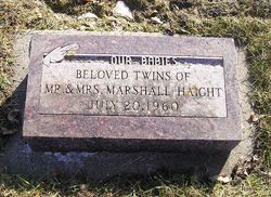
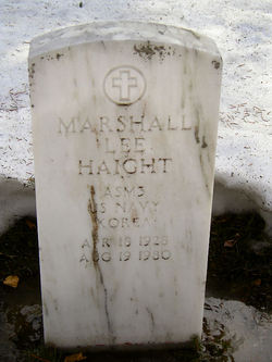
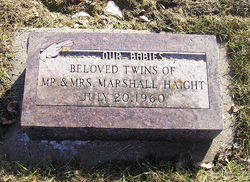
| Description | : | Rites Saturday July 23rd for twins Mary Jean & Marilyn Jane, infant twin daughters of Marshall & Zola Haight. One of the infants died Wednesday (20th) afternoon & the other early today (21st). Funeral services will be held at 10:00 a.m. Saturday at the Shaw-Messer chapel with the Rev. Glenn W. Prouty officiating. Burial will be in Mt Hope Cemetery. The bodies will be at the Shaw-Messer Chapel until the services. The girls were born Tues. Survivors include their parents Marshall & Zola Haight; two sisters, Cherri & Sheila; two brothers, Gary & Larry; & the maternal grandmother, Mrs. Ruth... Read More |
frequently asked questions (FAQ):
-
Where is Mary Jean Haight's memorial?
Mary Jean Haight's memorial is located at: Carrieton Cemetery, Carrieton, District Council of Orroroo Carrieton, Australia.
-
When did Mary Jean Haight death?
Mary Jean Haight death on 20 Jul 1960 in Watertown, Codington County, South Dakota, USA
-
Where are the coordinates of the Mary Jean Haight's memorial?
Latitude: -32.4441100
Longitude: 138.5510400
Family Members:
Parent
Siblings
Flowers:
Nearby Cemetories:
1. Carrieton Cemetery
Carrieton, District Council of Orroroo Carrieton, Australia
Coordinate: -32.4441100, 138.5510400
2. St. Raphael's Catholic Cemetery
Carrieton, District Council of Orroroo Carrieton, Australia
Coordinate: -32.4271010, 138.5313400
3. Eurelia Cemetery
Eurelia, District Council of Orroroo Carrieton, Australia
Coordinate: -32.5653900, 138.5754800
4. Johnburgh Cemetery
Johnburgh, District Council of Orroroo Carrieton, Australia
Coordinate: -32.4431327, 138.7518547
5. Hammond Cemetery
Hammond, District Council of Mount Remarkable, Australia
Coordinate: -32.5084900, 138.3495600
6. Amyton Cemetery
Amyton, District Council of Mount Remarkable, Australia
Coordinate: -32.6167700, 138.3432700
7. Belton Cemetery
Belton, District Council of Orroroo Carrieton, Australia
Coordinate: -32.2334000, 138.7188900
8. Morchard Cemetery
Morchard, District Council of Orroroo Carrieton, Australia
Coordinate: -32.7277813, 138.4786429
9. Bruce Cemetery
Bruce, District Council of Mount Remarkable, Australia
Coordinate: -32.4744440, 138.2031660
10. Orroroo Cemetery
Orroroo, District Council of Orroroo Carrieton, Australia
Coordinate: -32.7433308, 138.6176517
11. Bruce Lone Grave
Bruce, District Council of Mount Remarkable, Australia
Coordinate: -32.4250000, 138.1800000
12. Willowie Garden of Memories Cemetery
Willowie, District Council of Mount Remarkable, Australia
Coordinate: -32.6786940, 138.2886810
13. Avondale Station Lone Grave
Flinders Ranges Council, Australia
Coordinate: -32.0898700, 138.5995600
14. Bethlehem Lutheran Cemetery
Booleroo Centre, District Council of Mount Remarkable, Australia
Coordinate: -32.7886360, 138.3501700
15. Willowie Bethlehem Lutheran Cemetery
Willowie, District Council of Mount Remarkable, Australia
Coordinate: -32.7886430, 138.3501250
16. St. Catherine's Catholic Church Cemetery
Pekina, District Council of Orroroo Carrieton, Australia
Coordinate: -32.8393100, 138.5543600
17. Cradock Cemetery
Cradock, Flinders Ranges Council, Australia
Coordinate: -32.0497070, 138.4893020
18. Pekina Cemetery
Pekina, District Council of Orroroo Carrieton, Australia
Coordinate: -32.8426100, 138.5384800
19. Gordon Cemetery
Gordon, Flinders Ranges Council, Australia
Coordinate: -32.1232920, 138.2634750
20. Willochra Cemetery
Willochra, Flinders Ranges Council, Australia
Coordinate: -32.2301750, 138.1332610
21. Black Rock Cemetery
Peterborough, District Council of Peterborough, Australia
Coordinate: -32.8364055, 138.7414724
22. Quorn Town Cemetery
Quorn, Flinders Ranges Council, Australia
Coordinate: -32.3521176, 138.0606093
23. Wilmington Catholic Cemetery
District Council of Mount Remarkable, Australia
Coordinate: -32.6397080, 138.1034040
24. Kanyaka Homestead Historic Site
Gordon, Flinders Ranges Council, Australia
Coordinate: -32.0720710, 138.2998550


